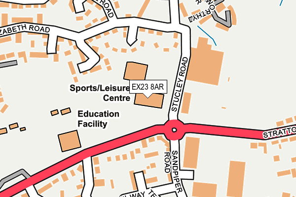
EX23 8AR is located in the Bude electoral ward, within the unitary authority of Cornwall and the English Parliamentary constituency of North Cornwall. The Sub Integrated Care Board (ICB) Location is NHS Cornwall and the Isles of Scilly ICB - 11N and the police force is Devon & Cornwall. This postcode has been in use since January 1993.


GetTheData
Source: OS OpenMap – Local (Ordnance Survey)
Source: OS VectorMap District (Ordnance Survey)
Licence: Open Government Licence (requires attribution)
| Easting | 221944 |
| Northing | 106155 |
| Latitude | 50.827474 |
| Longitude | -4.529638 |
GetTheData
Source: Open Postcode Geo
Licence: Open Government Licence
| Country | England |
| Postcode District | EX23 |
➜ See where EX23 is on a map ➜ Where is Bude? | |
GetTheData
Source: Land Registry Price Paid Data
Licence: Open Government Licence
Elevation or altitude of EX23 8AR as distance above sea level:
| Metres | Feet | |
|---|---|---|
| Elevation | 50m | 164ft |
Elevation is measured from the approximate centre of the postcode, to the nearest point on an OS contour line from OS Terrain 50, which has contour spacing of ten vertical metres.
➜ How high above sea level am I? Find the elevation of your current position using your device's GPS.
GetTheData
Source: Open Postcode Elevation
Licence: Open Government Licence
| Ward | Bude |
| Constituency | North Cornwall |
GetTheData
Source: ONS Postcode Database
Licence: Open Government Licence
| Splash Pool (Stratton Road) | Bude | 96m |
| Splashpool (Stratton Road) | Bude | 101m |
| Morrisons (Stratton Road) | Bude | 131m |
| Morrisons (Stratton Road) | Bude | 134m |
| Budehaven School | Bude | 327m |
GetTheData
Source: NaPTAN
Licence: Open Government Licence
GetTheData
Source: ONS Postcode Database
Licence: Open Government Licence


➜ Get more ratings from the Food Standards Agency
GetTheData
Source: Food Standards Agency
Licence: FSA terms & conditions
| Last Collection | |||
|---|---|---|---|
| Location | Mon-Fri | Sat | Distance |
| Berries Avenue | 16:15 | 12:00 | 796m |
| Strand | 16:30 | 12:00 | 1,005m |
| King Street | 16:30 | 12:00 | 1,019m |
GetTheData
Source: Dracos
Licence: Creative Commons Attribution-ShareAlike
The below table lists the International Territorial Level (ITL) codes (formerly Nomenclature of Territorial Units for Statistics (NUTS) codes) and Local Administrative Units (LAU) codes for EX23 8AR:
| ITL 1 Code | Name |
|---|---|
| TLK | South West (England) |
| ITL 2 Code | Name |
| TLK3 | Cornwall and Isles of Scilly |
| ITL 3 Code | Name |
| TLK30 | Cornwall and Isles of Scilly |
| LAU 1 Code | Name |
| E06000052 | Cornwall |
GetTheData
Source: ONS Postcode Directory
Licence: Open Government Licence
The below table lists the Census Output Area (OA), Lower Layer Super Output Area (LSOA), and Middle Layer Super Output Area (MSOA) for EX23 8AR:
| Code | Name | |
|---|---|---|
| OA | E00172768 | |
| LSOA | E01018937 | Cornwall 001B |
| MSOA | E02003931 | Cornwall 001 |
GetTheData
Source: ONS Postcode Directory
Licence: Open Government Licence
| EX23 8AH | Alford Close | 105m |
| EX23 8AE | Stratton Road | 107m |
| EX23 8BG | Kittiwake Court | 113m |
| EX23 8AL | Speedwell Close | 137m |
| EX23 8BQ | Puffin Close | 168m |
| EX23 8EG | Casebourne Mews | 187m |
| EX23 8DT | Bartlett Avenue | 211m |
| EX23 8AJ | Elizabeth Road | 212m |
| EX23 8DB | Tern Grove | 227m |
| EX23 8AA | Stratton Road | 231m |
GetTheData
Source: Open Postcode Geo; Land Registry Price Paid Data
Licence: Open Government Licence