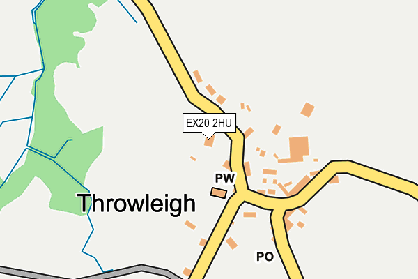
EX20 2HU is in Throwleigh, Okehampton. EX20 2HU is located in the Drewsteignton electoral ward, within the local authority district of West Devon and the English Parliamentary constituency of Central Devon. The Sub Integrated Care Board (ICB) Location is NHS Devon ICB - 15N and the police force is Devon & Cornwall. This postcode has been in use since January 1980.


GetTheData
Source: OS OpenMap – Local (Ordnance Survey)
Source: OS VectorMap District (Ordnance Survey)
Licence: Open Government Licence (requires attribution)
| Easting | 266759 |
| Northing | 90851 |
| Latitude | 50.701991 |
| Longitude | -3.888157 |
GetTheData
Source: Open Postcode Geo
Licence: Open Government Licence
| Locality | Throwleigh |
| Town/City | Okehampton |
| Country | England |
| Postcode District | EX20 |
➜ See where EX20 is on a map ➜ Where is Throwleigh? | |
GetTheData
Source: Land Registry Price Paid Data
Licence: Open Government Licence
Elevation or altitude of EX20 2HU as distance above sea level:
| Metres | Feet | |
|---|---|---|
| Elevation | 240m | 787ft |
Elevation is measured from the approximate centre of the postcode, to the nearest point on an OS contour line from OS Terrain 50, which has contour spacing of ten vertical metres.
➜ How high above sea level am I? Find the elevation of your current position using your device's GPS.
GetTheData
Source: Open Postcode Elevation
Licence: Open Government Licence
| Ward | Drewsteignton |
| Constituency | Central Devon |
GetTheData
Source: ONS Postcode Database
Licence: Open Government Licence
| Cross | Throwleigh | 142m |
| Cross | Throwleigh | 144m |
| Telephone Box (Wonson) | Wonson | 1,391m |
| Post Box | East Week | 1,669m |
| Post Box | East Week | 1,698m |
GetTheData
Source: NaPTAN
Licence: Open Government Licence
| Percentage of properties with Next Generation Access | 100.0% |
| Percentage of properties with Superfast Broadband | 46.2% |
| Percentage of properties with Ultrafast Broadband | 0.0% |
| Percentage of properties with Full Fibre Broadband | 0.0% |
Superfast Broadband is between 30Mbps and 300Mbps
Ultrafast Broadband is > 300Mbps
| Median download speed | 19.9Mbps |
| Average download speed | 18.0Mbps |
| Maximum download speed | 26.62Mbps |
| Median upload speed | 6.2Mbps |
| Average upload speed | 5.0Mbps |
| Maximum upload speed | 6.87Mbps |
| Percentage of properties unable to receive 2Mbps | 0.0% |
| Percentage of properties unable to receive 5Mbps | 0.0% |
| Percentage of properties unable to receive 10Mbps | 0.0% |
| Percentage of properties unable to receive 30Mbps | 53.8% |
GetTheData
Source: Ofcom
Licence: Ofcom Terms of Use (requires attribution)
Estimated total energy consumption in EX20 2HU by fuel type, 2015.
| Consumption (kWh) | 81,311 |
|---|---|
| Meter count | 14 |
| Mean (kWh/meter) | 5,808 |
| Median (kWh/meter) | 4,221 |
GetTheData
Source: Postcode level gas estimates: 2015 (experimental)
Source: Postcode level electricity estimates: 2015 (experimental)
Licence: Open Government Licence
GetTheData
Source: ONS Postcode Database
Licence: Open Government Licence
➜ Get more ratings from the Food Standards Agency
GetTheData
Source: Food Standards Agency
Licence: FSA terms & conditions
| Last Collection | |||
|---|---|---|---|
| Location | Mon-Fri | Sat | Distance |
| Sandy Park | 16:45 | 09:30 | 4,607m |
| Yellam | 15:45 | 09:00 | 6,066m |
| Middlecott | 15:45 | 09:30 | 6,759m |
GetTheData
Source: Dracos
Licence: Creative Commons Attribution-ShareAlike
The below table lists the International Territorial Level (ITL) codes (formerly Nomenclature of Territorial Units for Statistics (NUTS) codes) and Local Administrative Units (LAU) codes for EX20 2HU:
| ITL 1 Code | Name |
|---|---|
| TLK | South West (England) |
| ITL 2 Code | Name |
| TLK4 | Devon |
| ITL 3 Code | Name |
| TLK43 | Devon CC |
| LAU 1 Code | Name |
| E07000047 | West Devon |
GetTheData
Source: ONS Postcode Directory
Licence: Open Government Licence
The below table lists the Census Output Area (OA), Lower Layer Super Output Area (LSOA), and Middle Layer Super Output Area (MSOA) for EX20 2HU:
| Code | Name | |
|---|---|---|
| OA | E00102942 | |
| LSOA | E01020319 | West Devon 003B |
| MSOA | E02004231 | West Devon 003 |
GetTheData
Source: ONS Postcode Directory
Licence: Open Government Licence
| EX20 2HT | 119m | |
| EX20 2HS | Barton Cottages | 183m |
| EX20 2HX | 494m | |
| EX20 2JF | 673m | |
| EX20 2QF | 974m | |
| EX20 2QB | 1168m | |
| EX20 2HY | 1211m | |
| EX20 2QG | 1321m | |
| EX20 2JA | 1323m | |
| EX20 2QD | 1345m |
GetTheData
Source: Open Postcode Geo; Land Registry Price Paid Data
Licence: Open Government Licence