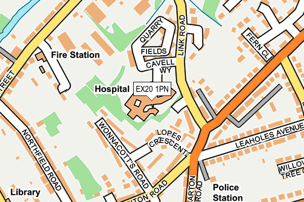
EX20 1PN is located in the Okehampton North electoral ward, within the local authority district of West Devon and the English Parliamentary constituency of Central Devon. The Sub Integrated Care Board (ICB) Location is NHS Devon ICB - 15N and the police force is Devon & Cornwall. This postcode has been in use since May 2003.


GetTheData
Source: OS OpenMap – Local (Ordnance Survey)
Source: OS VectorMap District (Ordnance Survey)
Licence: Open Government Licence (requires attribution)
| Easting | 259179 |
| Northing | 95492 |
| Latitude | 50.741913 |
| Longitude | -3.997201 |
GetTheData
Source: Open Postcode Geo
Licence: Open Government Licence
| Country | England |
| Postcode District | EX20 |
➜ See where EX20 is on a map ➜ Where is Okehampton? | |
GetTheData
Source: Land Registry Price Paid Data
Licence: Open Government Licence
Elevation or altitude of EX20 1PN as distance above sea level:
| Metres | Feet | |
|---|---|---|
| Elevation | 150m | 492ft |
Elevation is measured from the approximate centre of the postcode, to the nearest point on an OS contour line from OS Terrain 50, which has contour spacing of ten vertical metres.
➜ How high above sea level am I? Find the elevation of your current position using your device's GPS.
GetTheData
Source: Open Postcode Elevation
Licence: Open Government Licence
| Ward | Okehampton North |
| Constituency | Central Devon |
GetTheData
Source: ONS Postcode Database
Licence: Open Government Licence
| Hospital (Link Road) | Okehampton | 67m |
| Abbeyford Court (Link Road) | Okehampton | 81m |
| Limehayes Road (Crediton Road) | Okehampton | 215m |
| Limehayes Road (Crediton Road) | Okehampton | 237m |
| Leaholes Avenue (Limehayes Avenue) | Okehampton | 318m |
| Okehampton Station (Dartmoor Railway) | Okehampton | 1,062m |
| Okehampton Station | 1.1km |
| Sampford Courtenay Station | 4.6km |
GetTheData
Source: NaPTAN
Licence: Open Government Licence
GetTheData
Source: ONS Postcode Database
Licence: Open Government Licence

➜ Get more ratings from the Food Standards Agency
GetTheData
Source: Food Standards Agency
Licence: FSA terms & conditions
| Last Collection | |||
|---|---|---|---|
| Location | Mon-Fri | Sat | Distance |
| Northfield Road | 16:15 | 11:30 | 259m |
| Fore Street | 17:30 | 12:00 | 431m |
| Saville Mead | 16:00 | 11:30 | 457m |
GetTheData
Source: Dracos
Licence: Creative Commons Attribution-ShareAlike
The below table lists the International Territorial Level (ITL) codes (formerly Nomenclature of Territorial Units for Statistics (NUTS) codes) and Local Administrative Units (LAU) codes for EX20 1PN:
| ITL 1 Code | Name |
|---|---|
| TLK | South West (England) |
| ITL 2 Code | Name |
| TLK4 | Devon |
| ITL 3 Code | Name |
| TLK43 | Devon CC |
| LAU 1 Code | Name |
| E07000047 | West Devon |
GetTheData
Source: ONS Postcode Directory
Licence: Open Government Licence
The below table lists the Census Output Area (OA), Lower Layer Super Output Area (LSOA), and Middle Layer Super Output Area (MSOA) for EX20 1PN:
| Code | Name | |
|---|---|---|
| OA | E00102989 | |
| LSOA | E01020327 | West Devon 002A |
| MSOA | E02004230 | West Devon 002 |
GetTheData
Source: ONS Postcode Directory
Licence: Open Government Licence
| EX20 1LZ | Lopes Crescent | 66m |
| EX20 1TU | Abbeyford Court | 81m |
| EX20 1FU | Link Road | 96m |
| EX20 1LX | Wonnacotts Road | 97m |
| EX20 1TZ | Quarry Fields | 132m |
| EX20 1LY | Crediton Road | 141m |
| EX20 1NU | Crediton Road | 158m |
| EX20 1TX | Berryball Close | 171m |
| EX20 1LT | Neville Road | 184m |
| EX20 1NP | Barton Close | 197m |
GetTheData
Source: Open Postcode Geo; Land Registry Price Paid Data
Licence: Open Government Licence