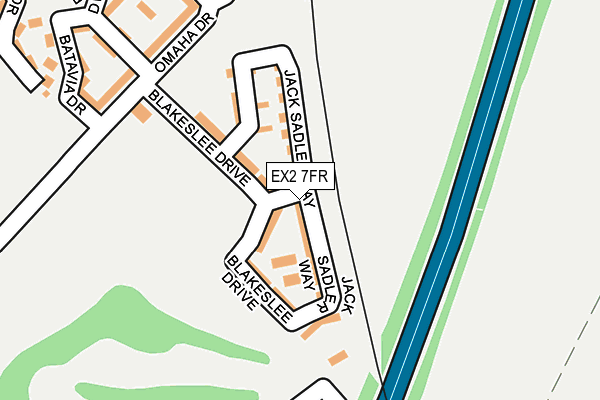
EX2 7FR lies on Seabee Walk in Exeter. EX2 7FR is located in the Topsham electoral ward, within the local authority district of Exeter and the English Parliamentary constituency of East Devon. The Sub Integrated Care Board (ICB) Location is NHS Devon ICB - 15N and the police force is Devon & Cornwall. This postcode has been in use since February 2012.


GetTheData
Source: OS OpenMap – Local (Ordnance Survey)
Source: OS VectorMap District (Ordnance Survey)
Licence: Open Government Licence (requires attribution)
| Easting | 296100 |
| Northing | 90051 |
| Latitude | 50.700777 |
| Longitude | -3.472622 |
GetTheData
Source: Open Postcode Geo
Licence: Open Government Licence
| Street | Seabee Walk |
| Town/City | Exeter |
| Country | England |
| Postcode District | EX2 |
➜ See where EX2 is on a map ➜ Where is Exeter? | |
GetTheData
Source: Land Registry Price Paid Data
Licence: Open Government Licence
Elevation or altitude of EX2 7FR as distance above sea level:
| Metres | Feet | |
|---|---|---|
| Elevation | 20m | 66ft |
Elevation is measured from the approximate centre of the postcode, to the nearest point on an OS contour line from OS Terrain 50, which has contour spacing of ten vertical metres.
➜ How high above sea level am I? Find the elevation of your current position using your device's GPS.
GetTheData
Source: Open Postcode Elevation
Licence: Open Government Licence
| Ward | Topsham |
| Constituency | East Devon |
GetTheData
Source: ONS Postcode Database
Licence: Open Government Licence
| Omaha Drive | Countess Wear | 216m |
| Omaha Drive | Countess Wear | 218m |
| River Plate Road | Countess Wear | 260m |
| River Plate Road | Countess Wear | 286m |
| Newcourt Way | Countess Wear | 572m |
| Newcourt Station | 0.5km |
| Digby & Sowton Station | 1.5km |
| Topsham Station | 1.7km |
GetTheData
Source: NaPTAN
Licence: Open Government Licence
| Percentage of properties with Next Generation Access | 100.0% |
| Percentage of properties with Superfast Broadband | 100.0% |
| Percentage of properties with Ultrafast Broadband | 0.0% |
| Percentage of properties with Full Fibre Broadband | 0.0% |
Superfast Broadband is between 30Mbps and 300Mbps
Ultrafast Broadband is > 300Mbps
| Percentage of properties unable to receive 2Mbps | 0.0% |
| Percentage of properties unable to receive 5Mbps | 0.0% |
| Percentage of properties unable to receive 10Mbps | 0.0% |
| Percentage of properties unable to receive 30Mbps | 0.0% |
GetTheData
Source: Ofcom
Licence: Ofcom Terms of Use (requires attribution)
GetTheData
Source: ONS Postcode Database
Licence: Open Government Licence


➜ Get more ratings from the Food Standards Agency
GetTheData
Source: Food Standards Agency
Licence: FSA terms & conditions
| Last Collection | |||
|---|---|---|---|
| Location | Mon-Fri | Sat | Distance |
| Tesco | 18:30 | 13:15 | 908m |
| Old Rydon Lane | 18:15 | 12:30 | 949m |
| Blue Ball | 18:15 | 12:30 | 989m |
GetTheData
Source: Dracos
Licence: Creative Commons Attribution-ShareAlike
The below table lists the International Territorial Level (ITL) codes (formerly Nomenclature of Territorial Units for Statistics (NUTS) codes) and Local Administrative Units (LAU) codes for EX2 7FR:
| ITL 1 Code | Name |
|---|---|
| TLK | South West (England) |
| ITL 2 Code | Name |
| TLK4 | Devon |
| ITL 3 Code | Name |
| TLK43 | Devon CC |
| LAU 1 Code | Name |
| E07000041 | Exeter |
GetTheData
Source: ONS Postcode Directory
Licence: Open Government Licence
The below table lists the Census Output Area (OA), Lower Layer Super Output Area (LSOA), and Middle Layer Super Output Area (MSOA) for EX2 7FR:
| Code | Name | |
|---|---|---|
| OA | E00101412 | |
| LSOA | E01020033 | Exeter 015C |
| MSOA | E02004163 | Exeter 015 |
GetTheData
Source: ONS Postcode Directory
Licence: Open Government Licence
| EX2 7FN | Blakeslee Drive | 32m |
| EX2 7FP | Jack Sadler Way | 50m |
| EX2 7FS | Poppin Court | 130m |
| EX2 7AY | Omaha Drive | 212m |
| EX2 7AU | Batavia Drive | 249m |
| EX2 7AT | Caroline Avenue | 276m |
| EX2 7FE | River Plate Road | 284m |
| EX2 7FH | Rhode Island Drive | 285m |
| EX2 7FD | River Plate Road | 295m |
| EX2 7AX | Robert Davy Road | 298m |
GetTheData
Source: Open Postcode Geo; Land Registry Price Paid Data
Licence: Open Government Licence