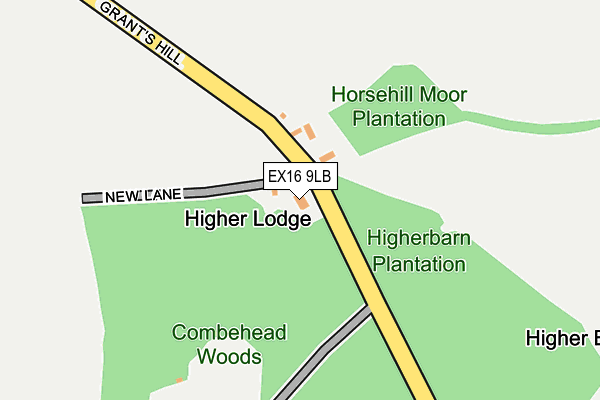
EX16 9LB is in Bampton, Tiverton. EX16 9LB is located in the Clare & Shuttern electoral ward, within the local authority district of Mid Devon and the English Parliamentary constituency of Tiverton and Honiton. The Sub Integrated Care Board (ICB) Location is NHS Devon ICB - 15N and the police force is Devon & Cornwall. This postcode has been in use since January 1980.


GetTheData
Source: OS OpenMap – Local (Ordnance Survey)
Source: OS VectorMap District (Ordnance Survey)
Licence: Open Government Licence (requires attribution)
| Easting | 293750 |
| Northing | 123151 |
| Latitude | 50.997911 |
| Longitude | -3.515487 |
GetTheData
Source: Open Postcode Geo
Licence: Open Government Licence
| Locality | Bampton |
| Town/City | Tiverton |
| Country | England |
| Postcode District | EX16 |
➜ See where EX16 is on a map | |
GetTheData
Source: Land Registry Price Paid Data
Licence: Open Government Licence
Elevation or altitude of EX16 9LB as distance above sea level:
| Metres | Feet | |
|---|---|---|
| Elevation | 220m | 722ft |
Elevation is measured from the approximate centre of the postcode, to the nearest point on an OS contour line from OS Terrain 50, which has contour spacing of ten vertical metres.
➜ How high above sea level am I? Find the elevation of your current position using your device's GPS.
GetTheData
Source: Open Postcode Elevation
Licence: Open Government Licence
| Ward | Clare & Shuttern |
| Constituency | Tiverton And Honiton |
GetTheData
Source: ONS Postcode Database
Licence: Open Government Licence
| Dulverton Road Garage (Blights Hill) | Exebridge | 1,231m |
| Dulverton Road Garage (Blights Hill) | Exebridge | 1,238m |
| Nurseries (B3222) | Exebridge | 1,381m |
| Nurseries (B3222) | Exebridge | 1,400m |
| Black Cat (A396) | Oakfordbridge | 1,516m |
GetTheData
Source: NaPTAN
Licence: Open Government Licence
| Percentage of properties with Next Generation Access | 100.0% |
| Percentage of properties with Superfast Broadband | 0.0% |
| Percentage of properties with Ultrafast Broadband | 0.0% |
| Percentage of properties with Full Fibre Broadband | 0.0% |
Superfast Broadband is between 30Mbps and 300Mbps
Ultrafast Broadband is > 300Mbps
| Percentage of properties unable to receive 2Mbps | 0.0% |
| Percentage of properties unable to receive 5Mbps | 0.0% |
| Percentage of properties unable to receive 10Mbps | 20.0% |
| Percentage of properties unable to receive 30Mbps | 100.0% |
GetTheData
Source: Ofcom
Licence: Ofcom Terms of Use (requires attribution)
GetTheData
Source: ONS Postcode Database
Licence: Open Government Licence


➜ Get more ratings from the Food Standards Agency
GetTheData
Source: Food Standards Agency
Licence: FSA terms & conditions
| Last Collection | |||
|---|---|---|---|
| Location | Mon-Fri | Sat | Distance |
| Bampton Post Office | 16:45 | 12:15 | 2,231m |
| Morebath Post Office | 15:30 | 10:30 | 2,504m |
| Oakford Post Office | 14:30 | 07:00 | 3,305m |
GetTheData
Source: Dracos
Licence: Creative Commons Attribution-ShareAlike
The below table lists the International Territorial Level (ITL) codes (formerly Nomenclature of Territorial Units for Statistics (NUTS) codes) and Local Administrative Units (LAU) codes for EX16 9LB:
| ITL 1 Code | Name |
|---|---|
| TLK | South West (England) |
| ITL 2 Code | Name |
| TLK4 | Devon |
| ITL 3 Code | Name |
| TLK43 | Devon CC |
| LAU 1 Code | Name |
| E07000042 | Mid Devon |
GetTheData
Source: ONS Postcode Directory
Licence: Open Government Licence
The below table lists the Census Output Area (OA), Lower Layer Super Output Area (LSOA), and Middle Layer Super Output Area (MSOA) for EX16 9LB:
| Code | Name | |
|---|---|---|
| OA | E00101499 | |
| LSOA | E01020050 | Mid Devon 001C |
| MSOA | E02004164 | Mid Devon 001 |
GetTheData
Source: ONS Postcode Directory
Licence: Open Government Licence
| EX16 9LD | 959m | |
| TA22 9BG | 970m | |
| TA22 9BE | Higher Grants | 1099m |
| TA22 9BD | 1190m | |
| TA22 9BB | Rose Cottages | 1233m |
| EX16 9DD | 1301m | |
| EX16 9HU | 1367m | |
| TA22 9BQ | 1574m | |
| EX16 9AA | 1574m | |
| TA22 9AY | 1601m |
GetTheData
Source: Open Postcode Geo; Land Registry Price Paid Data
Licence: Open Government Licence