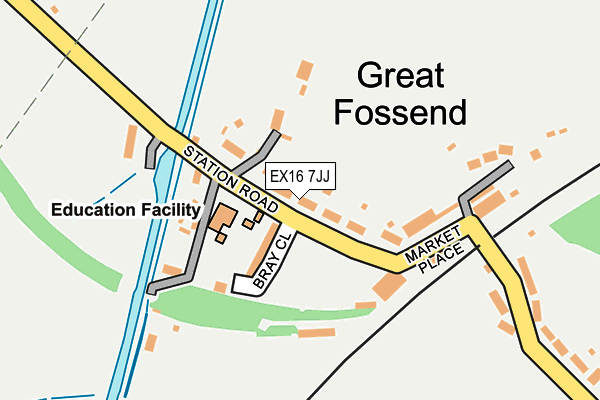
EX16 7JJ lies on Station Road in Burlescombe, Tiverton. EX16 7JJ is located in the Canonsleigh electoral ward, within the local authority district of Mid Devon and the English Parliamentary constituency of Tiverton and Honiton. The Sub Integrated Care Board (ICB) Location is NHS Devon ICB - 15N and the police force is Devon & Cornwall. This postcode has been in use since January 1980.


GetTheData
Source: OS OpenMap – Local (Ordnance Survey)
Source: OS VectorMap District (Ordnance Survey)
Licence: Open Government Licence (requires attribution)
| Easting | 307087 |
| Northing | 117007 |
| Latitude | 50.944981 |
| Longitude | -3.323927 |
GetTheData
Source: Open Postcode Geo
Licence: Open Government Licence
| Street | Station Road |
| Locality | Burlescombe |
| Town/City | Tiverton |
| Country | England |
| Postcode District | EX16 |
➜ See where EX16 is on a map ➜ Where is Great Fossend? | |
GetTheData
Source: Land Registry Price Paid Data
Licence: Open Government Licence
Elevation or altitude of EX16 7JJ as distance above sea level:
| Metres | Feet | |
|---|---|---|
| Elevation | 100m | 328ft |
Elevation is measured from the approximate centre of the postcode, to the nearest point on an OS contour line from OS Terrain 50, which has contour spacing of ten vertical metres.
➜ How high above sea level am I? Find the elevation of your current position using your device's GPS.
GetTheData
Source: Open Postcode Elevation
Licence: Open Government Licence
| Ward | Canonsleigh |
| Constituency | Tiverton And Honiton |
GetTheData
Source: ONS Postcode Database
Licence: Open Government Licence
| Ayshford Arms (Market Place) | Burlescombe | 130m |
| Ayshford Arms (Market Place) | Burlescombe | 133m |
| Bus Shelter (Harris Close) | Burlescombe | 964m |
| Maiden Down Cross (A38) | Red Ball | 1,635m |
| Maiden Down Cross (A38) | Red Ball | 1,642m |
| Tiverton Parkway Station | 4km |
GetTheData
Source: NaPTAN
Licence: Open Government Licence
| Percentage of properties with Next Generation Access | 100.0% |
| Percentage of properties with Superfast Broadband | 100.0% |
| Percentage of properties with Ultrafast Broadband | 0.0% |
| Percentage of properties with Full Fibre Broadband | 0.0% |
Superfast Broadband is between 30Mbps and 300Mbps
Ultrafast Broadband is > 300Mbps
| Median download speed | 40.0Mbps |
| Average download speed | 38.3Mbps |
| Maximum download speed | 43.70Mbps |
| Median upload speed | 10.0Mbps |
| Average upload speed | 9.3Mbps |
| Maximum upload speed | 11.57Mbps |
| Percentage of properties unable to receive 2Mbps | 0.0% |
| Percentage of properties unable to receive 5Mbps | 0.0% |
| Percentage of properties unable to receive 10Mbps | 0.0% |
| Percentage of properties unable to receive 30Mbps | 0.0% |
GetTheData
Source: Ofcom
Licence: Ofcom Terms of Use (requires attribution)
GetTheData
Source: ONS Postcode Database
Licence: Open Government Licence
| Last Collection | |||
|---|---|---|---|
| Location | Mon-Fri | Sat | Distance |
| Whipcott Cross | 12:00 | 11:30 | 2,018m |
| Ayshford | 09:00 | 07:00 | 3,010m |
| Greenham Bridge | 16:00 | 11:15 | 3,303m |
GetTheData
Source: Dracos
Licence: Creative Commons Attribution-ShareAlike
The below table lists the International Territorial Level (ITL) codes (formerly Nomenclature of Territorial Units for Statistics (NUTS) codes) and Local Administrative Units (LAU) codes for EX16 7JJ:
| ITL 1 Code | Name |
|---|---|
| TLK | South West (England) |
| ITL 2 Code | Name |
| TLK4 | Devon |
| ITL 3 Code | Name |
| TLK43 | Devon CC |
| LAU 1 Code | Name |
| E07000042 | Mid Devon |
GetTheData
Source: ONS Postcode Directory
Licence: Open Government Licence
The below table lists the Census Output Area (OA), Lower Layer Super Output Area (LSOA), and Middle Layer Super Output Area (MSOA) for EX16 7JJ:
| Code | Name | |
|---|---|---|
| OA | E00101475 | |
| LSOA | E01020046 | Mid Devon 001A |
| MSOA | E02004164 | Mid Devon 001 |
GetTheData
Source: ONS Postcode Directory
Licence: Open Government Licence
| EX16 7JL | Bray Close | 76m |
| EX16 7HJ | Market Place | 127m |
| EX16 7JH | 148m | |
| EX16 7JN | Old Station Mews | 154m |
| EX16 7JW | 342m | |
| EX16 7JS | 507m | |
| EX16 7JP | Barton Cottages | 536m |
| EX16 7JF | Canonsleigh | 544m |
| EX16 7SB | Hensons Drive | 872m |
| EX16 7HH | Pear Tree Close | 881m |
GetTheData
Source: Open Postcode Geo; Land Registry Price Paid Data
Licence: Open Government Licence