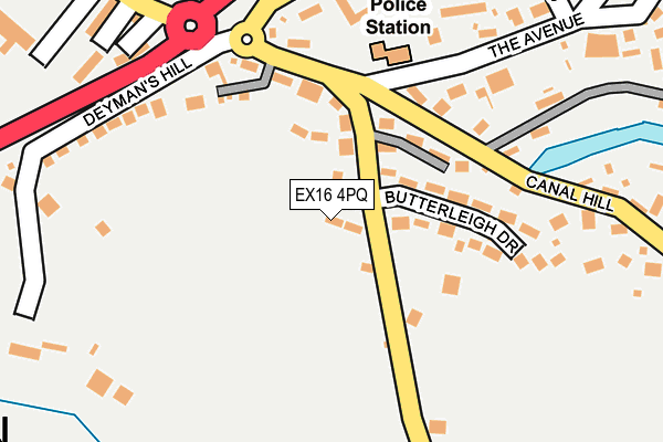
EX16 4PQ lies on Castlebar Close in Tiverton. EX16 4PQ is located in the Tiverton Cranmore electoral ward, within the local authority district of Mid Devon and the English Parliamentary constituency of Tiverton and Honiton. The Sub Integrated Care Board (ICB) Location is NHS Devon ICB - 15N and the police force is Devon & Cornwall. This postcode has been in use since April 1987.


GetTheData
Source: OS OpenMap – Local (Ordnance Survey)
Source: OS VectorMap District (Ordnance Survey)
Licence: Open Government Licence (requires attribution)
| Easting | 296085 |
| Northing | 112313 |
| Latitude | 50.900911 |
| Longitude | -3.479128 |
GetTheData
Source: Open Postcode Geo
Licence: Open Government Licence
| Street | Castlebar Close |
| Town/City | Tiverton |
| Country | England |
| Postcode District | EX16 |
➜ See where EX16 is on a map ➜ Where is Tiverton? | |
GetTheData
Source: Land Registry Price Paid Data
Licence: Open Government Licence
Elevation or altitude of EX16 4PQ as distance above sea level:
| Metres | Feet | |
|---|---|---|
| Elevation | 110m | 361ft |
Elevation is measured from the approximate centre of the postcode, to the nearest point on an OS contour line from OS Terrain 50, which has contour spacing of ten vertical metres.
➜ How high above sea level am I? Find the elevation of your current position using your device's GPS.
GetTheData
Source: Open Postcode Elevation
Licence: Open Government Licence
| Ward | Tiverton Cranmore |
| Constituency | Tiverton And Honiton |
GetTheData
Source: ONS Postcode Database
Licence: Open Government Licence
2019 19 FEB £405,000 |
2014 10 SEP £390,000 |
2000 8 DEC £167,500 |
2, CASTLEBAR CLOSE, TIVERTON, EX16 4PQ 2000 24 OCT £162,500 |
2000 5 JAN £170,000 |
2, CASTLEBAR CLOSE, TIVERTON, EX16 4PQ 1998 4 DEC £125,000 |
1998 21 AUG £120,000 |
GetTheData
Source: HM Land Registry Price Paid Data
Licence: Contains HM Land Registry data © Crown copyright and database right 2025. This data is licensed under the Open Government Licence v3.0.
| Canal Hill | Tiverton | 129m |
| Exeter Hill (Canal Hill) | Tiverton | 129m |
| The Avenue | Tiverton | 181m |
| The Oval (The Avenue) | Tiverton | 322m |
| Tesco Superstore (Blundell's Road) | Tiverton | 328m |
GetTheData
Source: NaPTAN
Licence: Open Government Licence
| Percentage of properties with Next Generation Access | 100.0% |
| Percentage of properties with Superfast Broadband | 100.0% |
| Percentage of properties with Ultrafast Broadband | 0.0% |
| Percentage of properties with Full Fibre Broadband | 0.0% |
Superfast Broadband is between 30Mbps and 300Mbps
Ultrafast Broadband is > 300Mbps
| Percentage of properties unable to receive 2Mbps | 0.0% |
| Percentage of properties unable to receive 5Mbps | 0.0% |
| Percentage of properties unable to receive 10Mbps | 0.0% |
| Percentage of properties unable to receive 30Mbps | 0.0% |
GetTheData
Source: Ofcom
Licence: Ofcom Terms of Use (requires attribution)
GetTheData
Source: ONS Postcode Database
Licence: Open Government Licence


➜ Get more ratings from the Food Standards Agency
GetTheData
Source: Food Standards Agency
Licence: FSA terms & conditions
| Last Collection | |||
|---|---|---|---|
| Location | Mon-Fri | Sat | Distance |
| Horn Hill | 12:00 | 11:15 | 429m |
| Town Hall | 17:30 | 12:00 | 694m |
| St Peter Street | 17:30 | 12:00 | 822m |
GetTheData
Source: Dracos
Licence: Creative Commons Attribution-ShareAlike
The below table lists the International Territorial Level (ITL) codes (formerly Nomenclature of Territorial Units for Statistics (NUTS) codes) and Local Administrative Units (LAU) codes for EX16 4PQ:
| ITL 1 Code | Name |
|---|---|
| TLK | South West (England) |
| ITL 2 Code | Name |
| TLK4 | Devon |
| ITL 3 Code | Name |
| TLK43 | Devon CC |
| LAU 1 Code | Name |
| E07000042 | Mid Devon |
GetTheData
Source: ONS Postcode Directory
Licence: Open Government Licence
The below table lists the Census Output Area (OA), Lower Layer Super Output Area (LSOA), and Middle Layer Super Output Area (MSOA) for EX16 4PQ:
| Code | Name | |
|---|---|---|
| OA | E00101510 | |
| LSOA | E01020052 | Mid Devon 004A |
| MSOA | E02004167 | Mid Devon 004 |
GetTheData
Source: ONS Postcode Directory
Licence: Open Government Licence
| EX16 4PN | Butterleigh Drive | 130m |
| EX16 4JJ | Canal Hill | 137m |
| EX16 4HT | Canal Hill | 161m |
| EX16 4LJ | Deymans Hill | 189m |
| EX16 4HQ | Old Road | 190m |
| EX16 4QD | Old Road | 192m |
| EX16 4HR | The Avenue | 222m |
| EX16 4HU | Canal Hill | 228m |
| EX16 4LL | Deymans Hill | 258m |
| EX16 4JY | Station Road | 260m |
GetTheData
Source: Open Postcode Geo; Land Registry Price Paid Data
Licence: Open Government Licence