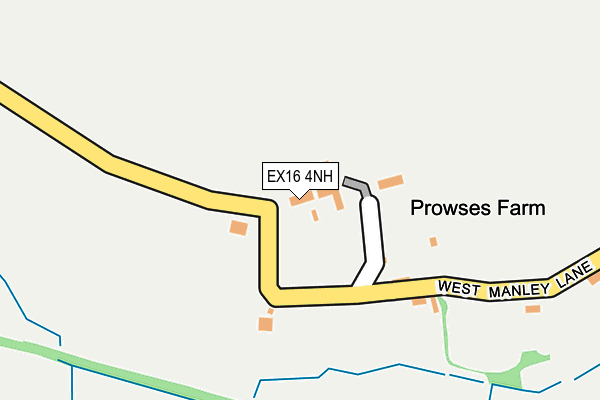
EX16 4NH lies on West Manley Lane in Tiverton. EX16 4NH is located in the Tiverton Cranmore electoral ward, within the local authority district of Mid Devon and the English Parliamentary constituency of Tiverton and Honiton. The Sub Integrated Care Board (ICB) Location is NHS Devon ICB - 15N and the police force is Devon & Cornwall. This postcode has been in use since January 1980.


GetTheData
Source: OS OpenMap – Local (Ordnance Survey)
Source: OS VectorMap District (Ordnance Survey)
Licence: Open Government Licence (requires attribution)
| Easting | 298265 |
| Northing | 112622 |
| Latitude | 50.904071 |
| Longitude | -3.448237 |
GetTheData
Source: Open Postcode Geo
Licence: Open Government Licence
| Street | West Manley Lane |
| Town/City | Tiverton |
| Country | England |
| Postcode District | EX16 |
➜ See where EX16 is on a map | |
GetTheData
Source: Land Registry Price Paid Data
Licence: Open Government Licence
Elevation or altitude of EX16 4NH as distance above sea level:
| Metres | Feet | |
|---|---|---|
| Elevation | 90m | 295ft |
Elevation is measured from the approximate centre of the postcode, to the nearest point on an OS contour line from OS Terrain 50, which has contour spacing of ten vertical metres.
➜ How high above sea level am I? Find the elevation of your current position using your device's GPS.
GetTheData
Source: Open Postcode Elevation
Licence: Open Government Licence
| Ward | Tiverton Cranmore |
| Constituency | Tiverton And Honiton |
GetTheData
Source: ONS Postcode Database
Licence: Open Government Licence
| Westcott Road (Glebelands Road) | Tidcombe | 571m |
| Uplowman Road (Post Hill) | Post Hill | 663m |
| Uplowman Road (Post Hill) | Post Hill | 670m |
| Fairway (Post Hill) | Post Hill | 762m |
| Fairway (Post Hill) | Post Hill | 796m |
GetTheData
Source: NaPTAN
Licence: Open Government Licence
| Percentage of properties with Next Generation Access | 100.0% |
| Percentage of properties with Superfast Broadband | 0.0% |
| Percentage of properties with Ultrafast Broadband | 0.0% |
| Percentage of properties with Full Fibre Broadband | 0.0% |
Superfast Broadband is between 30Mbps and 300Mbps
Ultrafast Broadband is > 300Mbps
| Median download speed | 4.4Mbps |
| Average download speed | 4.5Mbps |
| Maximum download speed | 8.62Mbps |
| Median upload speed | 0.6Mbps |
| Average upload speed | 0.6Mbps |
| Maximum upload speed | 0.85Mbps |
| Percentage of properties unable to receive 2Mbps | 0.0% |
| Percentage of properties unable to receive 5Mbps | 20.0% |
| Percentage of properties unable to receive 10Mbps | 80.0% |
| Percentage of properties unable to receive 30Mbps | 100.0% |
GetTheData
Source: Ofcom
Licence: Ofcom Terms of Use (requires attribution)
GetTheData
Source: ONS Postcode Database
Licence: Open Government Licence


➜ Get more ratings from the Food Standards Agency
GetTheData
Source: Food Standards Agency
Licence: FSA terms & conditions
| Last Collection | |||
|---|---|---|---|
| Location | Mon-Fri | Sat | Distance |
| Blundells | 16:45 | 11:45 | 1,274m |
| Lowman Way | 17:00 | 11:30 | 1,496m |
| Crazelowman | 15:45 | 09:00 | 1,567m |
GetTheData
Source: Dracos
Licence: Creative Commons Attribution-ShareAlike
The below table lists the International Territorial Level (ITL) codes (formerly Nomenclature of Territorial Units for Statistics (NUTS) codes) and Local Administrative Units (LAU) codes for EX16 4NH:
| ITL 1 Code | Name |
|---|---|
| TLK | South West (England) |
| ITL 2 Code | Name |
| TLK4 | Devon |
| ITL 3 Code | Name |
| TLK43 | Devon CC |
| LAU 1 Code | Name |
| E07000042 | Mid Devon |
GetTheData
Source: ONS Postcode Directory
Licence: Open Government Licence
The below table lists the Census Output Area (OA), Lower Layer Super Output Area (LSOA), and Middle Layer Super Output Area (MSOA) for EX16 4NH:
| Code | Name | |
|---|---|---|
| OA | E00101520 | |
| LSOA | E01020051 | Mid Devon 002B |
| MSOA | E02004165 | Mid Devon 002 |
GetTheData
Source: ONS Postcode Directory
Licence: Open Government Licence
| EX16 4EY | Westcott Road | 565m |
| EX16 4HF | Rippon Close | 591m |
| EX16 4EX | Follett Road | 613m |
| EX16 4HE | Ryder Close | 616m |
| EX16 4NQ | Mayfair | 655m |
| EX16 4HD | Follett Road | 678m |
| EX16 4EG | Polwhele Road | 680m |
| EX16 4NB | Blundells Road | 692m |
| EX16 4EB | Glebelands Road | 730m |
| EX16 4ND | Posthill | 732m |
GetTheData
Source: Open Postcode Geo; Land Registry Price Paid Data
Licence: Open Government Licence