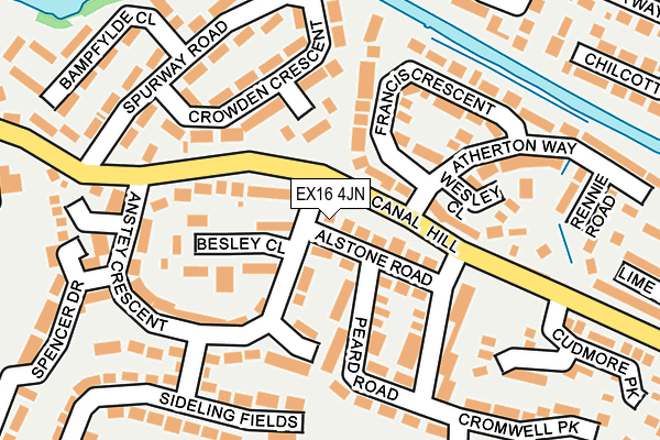
EX16 4JN lies on Anstey Crescent in Tiverton. EX16 4JN is located in the Tiverton Cranmore electoral ward, within the local authority district of Mid Devon and the English Parliamentary constituency of Tiverton and Honiton. The Sub Integrated Care Board (ICB) Location is NHS Devon ICB - 15N and the police force is Devon & Cornwall. This postcode has been in use since January 1980.


GetTheData
Source: OS OpenMap – Local (Ordnance Survey)
Source: OS VectorMap District (Ordnance Survey)
Licence: Open Government Licence (requires attribution)
| Easting | 296983 |
| Northing | 112114 |
| Latitude | 50.899277 |
| Longitude | -3.466320 |
GetTheData
Source: Open Postcode Geo
Licence: Open Government Licence
| Street | Anstey Crescent |
| Town/City | Tiverton |
| Country | England |
| Postcode District | EX16 |
➜ See where EX16 is on a map ➜ Where is Tiverton? | |
GetTheData
Source: Land Registry Price Paid Data
Licence: Open Government Licence
Elevation or altitude of EX16 4JN as distance above sea level:
| Metres | Feet | |
|---|---|---|
| Elevation | 110m | 361ft |
Elevation is measured from the approximate centre of the postcode, to the nearest point on an OS contour line from OS Terrain 50, which has contour spacing of ten vertical metres.
➜ How high above sea level am I? Find the elevation of your current position using your device's GPS.
GetTheData
Source: Open Postcode Elevation
Licence: Open Government Licence
| Ward | Tiverton Cranmore |
| Constituency | Tiverton And Honiton |
GetTheData
Source: ONS Postcode Database
Licence: Open Government Licence
| Atherton Way (Canal Hill) | Tidcombe | 50m |
| Atherton Way (Canal Hill) | Tidcombe | 89m |
| Spurway Road (Canal Hill) | Tidcombe | 168m |
| Spurway Road (Canal Hill) | Tidcombe | 198m |
| Bonville Crescent | Tidcombe | 328m |
GetTheData
Source: NaPTAN
Licence: Open Government Licence
| Percentage of properties with Next Generation Access | 100.0% |
| Percentage of properties with Superfast Broadband | 100.0% |
| Percentage of properties with Ultrafast Broadband | 0.0% |
| Percentage of properties with Full Fibre Broadband | 0.0% |
Superfast Broadband is between 30Mbps and 300Mbps
Ultrafast Broadband is > 300Mbps
| Percentage of properties unable to receive 2Mbps | 0.0% |
| Percentage of properties unable to receive 5Mbps | 0.0% |
| Percentage of properties unable to receive 10Mbps | 0.0% |
| Percentage of properties unable to receive 30Mbps | 0.0% |
GetTheData
Source: Ofcom
Licence: Ofcom Terms of Use (requires attribution)
GetTheData
Source: ONS Postcode Database
Licence: Open Government Licence


➜ Get more ratings from the Food Standards Agency
GetTheData
Source: Food Standards Agency
Licence: FSA terms & conditions
| Last Collection | |||
|---|---|---|---|
| Location | Mon-Fri | Sat | Distance |
| Horn Hill | 12:00 | 11:15 | 816m |
| Blundells | 16:45 | 11:45 | 842m |
| Lowman Way | 17:00 | 11:30 | 1,320m |
GetTheData
Source: Dracos
Licence: Creative Commons Attribution-ShareAlike
The below table lists the International Territorial Level (ITL) codes (formerly Nomenclature of Territorial Units for Statistics (NUTS) codes) and Local Administrative Units (LAU) codes for EX16 4JN:
| ITL 1 Code | Name |
|---|---|
| TLK | South West (England) |
| ITL 2 Code | Name |
| TLK4 | Devon |
| ITL 3 Code | Name |
| TLK43 | Devon CC |
| LAU 1 Code | Name |
| E07000042 | Mid Devon |
GetTheData
Source: ONS Postcode Directory
Licence: Open Government Licence
The below table lists the Census Output Area (OA), Lower Layer Super Output Area (LSOA), and Middle Layer Super Output Area (MSOA) for EX16 4JN:
| Code | Name | |
|---|---|---|
| OA | E00101517 | |
| LSOA | E01020051 | Mid Devon 002B |
| MSOA | E02004165 | Mid Devon 002 |
GetTheData
Source: ONS Postcode Directory
Licence: Open Government Licence
| EX16 4JL | Alstone Road | 17m |
| EX16 4JF | Besley Close | 64m |
| EX16 4LH | Alstone Road | 86m |
| EX16 4PA | Besley Close | 111m |
| EX16 4ET | Crowden Crescent | 115m |
| EX16 4JW | Anstey Crescent | 116m |
| EX16 4HA | Culver Close | 135m |
| EX16 4LG | Peard Road | 137m |
| EX16 4EP | Francis Crescent | 144m |
| EX16 4EN | Wesley Close | 154m |
GetTheData
Source: Open Postcode Geo; Land Registry Price Paid Data
Licence: Open Government Licence