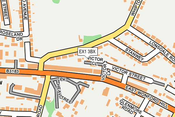
EX1 3BX lies on Victor Close in Exeter. EX1 3BX is located in the Heavitree electoral ward, within the local authority district of Exeter and the English Parliamentary constituency of Exeter. The Sub Integrated Care Board (ICB) Location is NHS Devon ICB - 15N and the police force is Devon & Cornwall. This postcode has been in use since January 1980.


GetTheData
Source: OS OpenMap – Local (Ordnance Survey)
Source: OS VectorMap District (Ordnance Survey)
Licence: Open Government Licence (requires attribution)
| Easting | 294291 |
| Northing | 92408 |
| Latitude | 50.721651 |
| Longitude | -3.498891 |
GetTheData
Source: Open Postcode Geo
Licence: Open Government Licence
| Street | Victor Close |
| Town/City | Exeter |
| Country | England |
| Postcode District | EX1 |
➜ See where EX1 is on a map ➜ Where is Exeter? | |
GetTheData
Source: Land Registry Price Paid Data
Licence: Open Government Licence
Elevation or altitude of EX1 3BX as distance above sea level:
| Metres | Feet | |
|---|---|---|
| Elevation | 30m | 98ft |
Elevation is measured from the approximate centre of the postcode, to the nearest point on an OS contour line from OS Terrain 50, which has contour spacing of ten vertical metres.
➜ How high above sea level am I? Find the elevation of your current position using your device's GPS.
GetTheData
Source: Open Postcode Elevation
Licence: Open Government Licence
| Ward | Heavitree |
| Constituency | Exeter |
GetTheData
Source: ONS Postcode Database
Licence: Open Government Licence
| Butts Road (Fore Street) | Heavitree | 119m |
| Victor Street (East Wonford Hill) | Heavitree | 127m |
| Butts Road (Fore Street) | Heavitree | 175m |
| St Loyes Road (East Wonford Hill) | Heavitree | 226m |
| Whiteway Drive (Sweetbrier Lane) | Heavitree | 403m |
| Polsloe Bridge Station | 1.1km |
| St James Park (Devon) Station | 1.9km |
| Digby & Sowton Station | 2km |
GetTheData
Source: NaPTAN
Licence: Open Government Licence
| Percentage of properties with Next Generation Access | 100.0% |
| Percentage of properties with Superfast Broadband | 100.0% |
| Percentage of properties with Ultrafast Broadband | 100.0% |
| Percentage of properties with Full Fibre Broadband | 100.0% |
Superfast Broadband is between 30Mbps and 300Mbps
Ultrafast Broadband is > 300Mbps
| Percentage of properties unable to receive 2Mbps | 0.0% |
| Percentage of properties unable to receive 5Mbps | 0.0% |
| Percentage of properties unable to receive 10Mbps | 0.0% |
| Percentage of properties unable to receive 30Mbps | 0.0% |
GetTheData
Source: Ofcom
Licence: Ofcom Terms of Use (requires attribution)
GetTheData
Source: ONS Postcode Database
Licence: Open Government Licence


➜ Get more ratings from the Food Standards Agency
GetTheData
Source: Food Standards Agency
Licence: FSA terms & conditions
| Last Collection | |||
|---|---|---|---|
| Location | Mon-Fri | Sat | Distance |
| Heavitree Park | 18:00 | 13:00 | 152m |
| Chard Road Post Office | 19:00 | 12:00 | 299m |
| Cowick Street Post Office | 19:00 | 12:00 | 504m |
GetTheData
Source: Dracos
Licence: Creative Commons Attribution-ShareAlike
The below table lists the International Territorial Level (ITL) codes (formerly Nomenclature of Territorial Units for Statistics (NUTS) codes) and Local Administrative Units (LAU) codes for EX1 3BX:
| ITL 1 Code | Name |
|---|---|
| TLK | South West (England) |
| ITL 2 Code | Name |
| TLK4 | Devon |
| ITL 3 Code | Name |
| TLK43 | Devon CC |
| LAU 1 Code | Name |
| E07000041 | Exeter |
GetTheData
Source: ONS Postcode Directory
Licence: Open Government Licence
The below table lists the Census Output Area (OA), Lower Layer Super Output Area (LSOA), and Middle Layer Super Output Area (MSOA) for EX1 3BX:
| Code | Name | |
|---|---|---|
| OA | E00101165 | |
| LSOA | E01019986 | Exeter 007A |
| MSOA | E02004155 | Exeter 007 |
GetTheData
Source: ONS Postcode Directory
Licence: Open Government Licence
| EX1 3DS | Whipton Lane | 32m |
| EX1 3BR | Fore Street | 65m |
| EX1 3BT | Victor Street | 106m |
| EX1 3BS | East Wonford Hill | 115m |
| EX1 3BP | Heavitree Park | 152m |
| EX1 3DR | Stanwey | 162m |
| EX1 3BU | Victor Street | 184m |
| EX1 3BZ | East Wonford Hill | 189m |
| EX2 5PW | Butts Road | 203m |
| EX2 5HB | Glenmore Road | 211m |
GetTheData
Source: Open Postcode Geo; Land Registry Price Paid Data
Licence: Open Government Licence