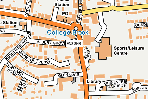
EN8 8NR is located in the Cheshunt South and Theobalds electoral ward, within the local authority district of Broxbourne and the English Parliamentary constituency of Broxbourne. The Sub Integrated Care Board (ICB) Location is NHS Hertfordshire and West Essex ICB - 06K and the police force is Hertfordshire. This postcode has been in use since January 1980.


GetTheData
Source: OS OpenMap – Local (Ordnance Survey)
Source: OS VectorMap District (Ordnance Survey)
Licence: Open Government Licence (requires attribution)
| Easting | 535895 |
| Northing | 202112 |
| Latitude | 51.701305 |
| Longitude | -0.034911 |
GetTheData
Source: Open Postcode Geo
Licence: Open Government Licence
| Country | England |
| Postcode District | EN8 |
➜ See where EN8 is on a map ➜ Where is Cheshunt? | |
GetTheData
Source: Land Registry Price Paid Data
Licence: Open Government Licence
Elevation or altitude of EN8 8NR as distance above sea level:
| Metres | Feet | |
|---|---|---|
| Elevation | 30m | 98ft |
Elevation is measured from the approximate centre of the postcode, to the nearest point on an OS contour line from OS Terrain 50, which has contour spacing of ten vertical metres.
➜ How high above sea level am I? Find the elevation of your current position using your device's GPS.
GetTheData
Source: Open Postcode Elevation
Licence: Open Government Licence
| Ward | Cheshunt South And Theobalds |
| Constituency | Broxbourne |
GetTheData
Source: ONS Postcode Database
Licence: Open Government Licence
| Old Pond (Crossbrook Street) | Cheshunt | 24m |
| Old Pond (College Road) | Cheshunt | 75m |
| Old Pond (Turners Hill) | Cheshunt | 76m |
| King Arthur Court (Turners Hill) | Cheshunt | 139m |
| Moxom Avenue (Windmill Lane) | Cheshunt | 193m |
| Cheshunt Station | 0.8km |
| Theobalds Grove Station | 1km |
| Waltham Cross Station | 1.9km |
GetTheData
Source: NaPTAN
Licence: Open Government Licence
GetTheData
Source: ONS Postcode Database
Licence: Open Government Licence


➜ Get more ratings from the Food Standards Agency
GetTheData
Source: Food Standards Agency
Licence: FSA terms & conditions
| Last Collection | |||
|---|---|---|---|
| Location | Mon-Fri | Sat | Distance |
| Turners Hill P.o | 18:30 | 12:00 | 141m |
| Cheshunt Library | 17:30 | 11:30 | 199m |
| Clarendon Road | 17:30 | 11:30 | 460m |
GetTheData
Source: Dracos
Licence: Creative Commons Attribution-ShareAlike
The below table lists the International Territorial Level (ITL) codes (formerly Nomenclature of Territorial Units for Statistics (NUTS) codes) and Local Administrative Units (LAU) codes for EN8 8NR:
| ITL 1 Code | Name |
|---|---|
| TLH | East |
| ITL 2 Code | Name |
| TLH2 | Bedfordshire and Hertfordshire |
| ITL 3 Code | Name |
| TLH23 | Hertfordshire CC |
| LAU 1 Code | Name |
| E07000095 | Broxbourne |
GetTheData
Source: ONS Postcode Directory
Licence: Open Government Licence
The below table lists the Census Output Area (OA), Lower Layer Super Output Area (LSOA), and Middle Layer Super Output Area (MSOA) for EN8 8NR:
| Code | Name | |
|---|---|---|
| OA | E00118548 | |
| LSOA | E01023334 | Broxbourne 012C |
| MSOA | E02004854 | Broxbourne 012 |
GetTheData
Source: ONS Postcode Directory
Licence: Open Government Licence
| EN8 8NQ | Clayton Parade | 33m |
| EN8 9LP | Manor Croft Parade | 72m |
| EN8 8NS | Albury Grove Road | 100m |
| EN8 8QE | Gaywood Avenue | 117m |
| EN8 8NJ | Turners Hill | 123m |
| EN8 9NU | Newnham Parade | 128m |
| EN8 8QD | Gaywood Avenue | 129m |
| EN8 9LS | College Road | 144m |
| EN8 8SA | Turners Hill | 144m |
| EN8 8LJ | Westbury | 148m |
GetTheData
Source: Open Postcode Geo; Land Registry Price Paid Data
Licence: Open Government Licence