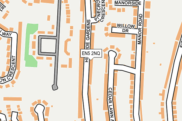
EN5 2NQ lies on Hillside Gardens in Barnet. EN5 2NQ is located in the Underhill electoral ward, within the London borough of Barnet and the English Parliamentary constituency of Chipping Barnet. The Sub Integrated Care Board (ICB) Location is NHS North Central London ICB - 93C and the police force is Metropolitan Police. This postcode has been in use since January 1980.


GetTheData
Source: OS OpenMap – Local (Ordnance Survey)
Source: OS VectorMap District (Ordnance Survey)
Licence: Open Government Licence (requires attribution)
| Easting | 524193 |
| Northing | 195943 |
| Latitude | 51.648574 |
| Longitude | -0.206344 |
GetTheData
Source: Open Postcode Geo
Licence: Open Government Licence
| Street | Hillside Gardens |
| Town/City | Barnet |
| Country | England |
| Postcode District | EN5 |
➜ See where EN5 is on a map ➜ Where is Barnet? | |
GetTheData
Source: Land Registry Price Paid Data
Licence: Open Government Licence
Elevation or altitude of EN5 2NQ as distance above sea level:
| Metres | Feet | |
|---|---|---|
| Elevation | 110m | 361ft |
Elevation is measured from the approximate centre of the postcode, to the nearest point on an OS contour line from OS Terrain 50, which has contour spacing of ten vertical metres.
➜ How high above sea level am I? Find the elevation of your current position using your device's GPS.
GetTheData
Source: Open Postcode Elevation
Licence: Open Government Licence
| Ward | Underhill |
| Constituency | Chipping Barnet |
GetTheData
Source: ONS Postcode Database
Licence: Open Government Licence
| Willow Drive (Manor Road) | Chipping Barnet | 174m |
| Willow Drive (Manor Road) | Chipping Barnet | 191m |
| Leeside (Manor Road) | Chipping Barnet | 299m |
| Leeside (Mays Lane) | Chipping Barnet | 330m |
| Kenerne Drive (Mays Lane) | Chipping Barnet | 374m |
| High Barnet Underground Station | Barnet | 862m |
| New Barnet Station | 2.3km |
| Oakleigh Park Station | 3km |
| Hadley Wood Station | 3km |
GetTheData
Source: NaPTAN
Licence: Open Government Licence
| Percentage of properties with Next Generation Access | 100.0% |
| Percentage of properties with Superfast Broadband | 100.0% |
| Percentage of properties with Ultrafast Broadband | 100.0% |
| Percentage of properties with Full Fibre Broadband | 100.0% |
Superfast Broadband is between 30Mbps and 300Mbps
Ultrafast Broadband is > 300Mbps
| Median download speed | 26.5Mbps |
| Average download speed | 21.3Mbps |
| Maximum download speed | 45.85Mbps |
| Median upload speed | 5.0Mbps |
| Average upload speed | 4.6Mbps |
| Maximum upload speed | 8.21Mbps |
| Percentage of properties unable to receive 2Mbps | 0.0% |
| Percentage of properties unable to receive 5Mbps | 0.0% |
| Percentage of properties unable to receive 10Mbps | 0.0% |
| Percentage of properties unable to receive 30Mbps | 0.0% |
GetTheData
Source: Ofcom
Licence: Ofcom Terms of Use (requires attribution)
Estimated total energy consumption in EN5 2NQ by fuel type, 2015.
| Consumption (kWh) | 439,350 |
|---|---|
| Meter count | 21 |
| Mean (kWh/meter) | 20,921 |
| Median (kWh/meter) | 20,210 |
| Consumption (kWh) | 71,910 |
|---|---|
| Meter count | 17 |
| Mean (kWh/meter) | 4,230 |
| Median (kWh/meter) | 3,974 |
GetTheData
Source: Postcode level gas estimates: 2015 (experimental)
Source: Postcode level electricity estimates: 2015 (experimental)
Licence: Open Government Licence
GetTheData
Source: ONS Postcode Database
Licence: Open Government Licence


➜ Get more ratings from the Food Standards Agency
GetTheData
Source: Food Standards Agency
Licence: FSA terms & conditions
| Last Collection | |||
|---|---|---|---|
| Location | Mon-Fri | Sat | Distance |
| Cedar Lawn Avenue | 17:30 | 12:00 | 56m |
| Hillside Gardens | 17:30 | 12:00 | 226m |
| Leeside | 18:15 | 12:00 | 362m |
GetTheData
Source: Dracos
Licence: Creative Commons Attribution-ShareAlike
The below table lists the International Territorial Level (ITL) codes (formerly Nomenclature of Territorial Units for Statistics (NUTS) codes) and Local Administrative Units (LAU) codes for EN5 2NQ:
| ITL 1 Code | Name |
|---|---|
| TLI | London |
| ITL 2 Code | Name |
| TLI7 | Outer London - West and North West |
| ITL 3 Code | Name |
| TLI71 | Barnet |
| LAU 1 Code | Name |
| E09000003 | Barnet |
GetTheData
Source: ONS Postcode Directory
Licence: Open Government Licence
The below table lists the Census Output Area (OA), Lower Layer Super Output Area (LSOA), and Middle Layer Super Output Area (MSOA) for EN5 2NQ:
| Code | Name | |
|---|---|---|
| OA | E00001431 | |
| LSOA | E01000292 | Barnet 001E |
| MSOA | E02000024 | Barnet 001 |
GetTheData
Source: ONS Postcode Directory
Licence: Open Government Licence
| EN5 2LW | Cedar Lawn Avenue | 84m |
| EN5 2LQ | Willow Drive | 116m |
| EN5 2NL | Hillside Gardens | 136m |
| EN5 2LE | Manor Road | 158m |
| EN5 2TW | Rodings Row | 175m |
| EN5 2LN | Cedar Lawn Avenue | 177m |
| EN5 2LP | Cedar Lawn Avenue | 178m |
| EN5 2LH | Manor Road | 181m |
| EN5 2LF | Manor Road | 185m |
| EN5 2JY | Manor Road | 186m |
GetTheData
Source: Open Postcode Geo; Land Registry Price Paid Data
Licence: Open Government Licence