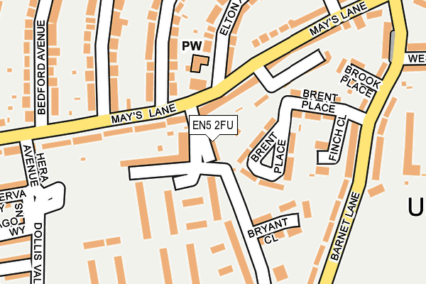
EN5 2FU is located in the Underhill electoral ward, within the London borough of Barnet and the English Parliamentary constituency of Chipping Barnet. The Sub Integrated Care Board (ICB) Location is NHS North Central London ICB - 93C and the police force is Metropolitan Police. This postcode has been in use since November 2016.


GetTheData
Source: OS OpenMap – Local (Ordnance Survey)
Source: OS VectorMap District (Ordnance Survey)
Licence: Open Government Licence (requires attribution)
| Easting | 524892 |
| Northing | 195675 |
| Latitude | 51.646014 |
| Longitude | -0.196317 |
GetTheData
Source: Open Postcode Geo
Licence: Open Government Licence
| Country | England |
| Postcode District | EN5 |
➜ See where EN5 is on a map ➜ Where is Barnet? | |
GetTheData
Source: Land Registry Price Paid Data
Licence: Open Government Licence
Elevation or altitude of EN5 2FU as distance above sea level:
| Metres | Feet | |
|---|---|---|
| Elevation | 90m | 295ft |
Elevation is measured from the approximate centre of the postcode, to the nearest point on an OS contour line from OS Terrain 50, which has contour spacing of ten vertical metres.
➜ How high above sea level am I? Find the elevation of your current position using your device's GPS.
GetTheData
Source: Open Postcode Elevation
Licence: Open Government Licence
| Ward | Underhill |
| Constituency | Chipping Barnet |
GetTheData
Source: ONS Postcode Database
Licence: Open Government Licence
| Dollis Valley Way | Chipping Barnet | 259m |
| Underhill (Barnet Lane) | Chipping Barnet | 314m |
| Underhill | Chipping Barnet | 373m |
| Westcombe Drive | Chipping Barnet | 392m |
| Fairfield Way | Chipping Barnet | 408m |
| High Barnet Underground Station | Barnet | 523m |
| New Barnet Station | 1.6km |
| Oakleigh Park Station | 2.3km |
| Hadley Wood Station | 2.9km |
GetTheData
Source: NaPTAN
Licence: Open Government Licence
| Percentage of properties with Next Generation Access | 100.0% |
| Percentage of properties with Superfast Broadband | 100.0% |
| Percentage of properties with Ultrafast Broadband | 100.0% |
| Percentage of properties with Full Fibre Broadband | 0.0% |
Superfast Broadband is between 30Mbps and 300Mbps
Ultrafast Broadband is > 300Mbps
| Median download speed | 66.9Mbps |
| Average download speed | 55.3Mbps |
| Maximum download speed | 78.20Mbps |
| Median upload speed | 19.9Mbps |
| Average upload speed | 15.8Mbps |
| Maximum upload speed | 20.00Mbps |
| Percentage of properties unable to receive 2Mbps | 0.0% |
| Percentage of properties unable to receive 5Mbps | 0.0% |
| Percentage of properties unable to receive 10Mbps | 0.0% |
| Percentage of properties unable to receive 30Mbps | 0.0% |
GetTheData
Source: Ofcom
Licence: Ofcom Terms of Use (requires attribution)
GetTheData
Source: ONS Postcode Database
Licence: Open Government Licence


➜ Get more ratings from the Food Standards Agency
GetTheData
Source: Food Standards Agency
Licence: FSA terms & conditions
| Last Collection | |||
|---|---|---|---|
| Location | Mon-Fri | Sat | Distance |
| Milton Avenue | 17:30 | 12:00 | 348m |
| Bedford Avenue | 17:30 | 12:00 | 390m |
| Sherrards Way | 17:30 | 12:00 | 513m |
GetTheData
Source: Dracos
Licence: Creative Commons Attribution-ShareAlike
The below table lists the International Territorial Level (ITL) codes (formerly Nomenclature of Territorial Units for Statistics (NUTS) codes) and Local Administrative Units (LAU) codes for EN5 2FU:
| ITL 1 Code | Name |
|---|---|
| TLI | London |
| ITL 2 Code | Name |
| TLI7 | Outer London - West and North West |
| ITL 3 Code | Name |
| TLI71 | Barnet |
| LAU 1 Code | Name |
| E09000003 | Barnet |
GetTheData
Source: ONS Postcode Directory
Licence: Open Government Licence
The below table lists the Census Output Area (OA), Lower Layer Super Output Area (LSOA), and Middle Layer Super Output Area (MSOA) for EN5 2FU:
| Code | Name | |
|---|---|---|
| OA | E00001403 | |
| LSOA | E01000289 | Barnet 004D |
| MSOA | E02000027 | Barnet 004 |
GetTheData
Source: ONS Postcode Directory
Licence: Open Government Licence
| EN5 2DR | Brent Place | 53m |
| EN5 2DU | Mays Lane | 57m |
| EN5 2DS | Brent Place | 89m |
| EN5 2TX | Dollis Valley Drive | 148m |
| EN5 2DX | Mays Lane | 153m |
| EN5 2DP | Brent Place | 159m |
| EN5 2TG | Bryant Close | 161m |
| EN5 2HB | Woodfall Avenue | 164m |
| EN5 2HA | Woodfall Avenue | 185m |
| EN5 2TY | Dollis Valley Drive | 191m |
GetTheData
Source: Open Postcode Geo; Land Registry Price Paid Data
Licence: Open Government Licence