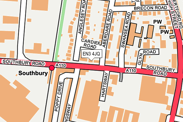
EN3 4JQ lies on Southbury Road in Enfield. EN3 4JQ is located in the Carterhatch electoral ward, within the London borough of Enfield and the English Parliamentary constituency of Edmonton. The Sub Integrated Care Board (ICB) Location is NHS North Central London ICB - 93C and the police force is Metropolitan Police. This postcode has been in use since January 1980.


GetTheData
Source: OS OpenMap – Local (Ordnance Survey)
Source: OS VectorMap District (Ordnance Survey)
Licence: Open Government Licence (requires attribution)
| Easting | 534970 |
| Northing | 196259 |
| Latitude | 51.648933 |
| Longitude | -0.050548 |
GetTheData
Source: Open Postcode Geo
Licence: Open Government Licence
| Street | Southbury Road |
| Town/City | Enfield |
| Country | England |
| Postcode District | EN3 |
➜ See where EN3 is on a map ➜ Where is London? | |
GetTheData
Source: Land Registry Price Paid Data
Licence: Open Government Licence
Elevation or altitude of EN3 4JQ as distance above sea level:
| Metres | Feet | |
|---|---|---|
| Elevation | 20m | 66ft |
Elevation is measured from the approximate centre of the postcode, to the nearest point on an OS contour line from OS Terrain 50, which has contour spacing of ten vertical metres.
➜ How high above sea level am I? Find the elevation of your current position using your device's GPS.
GetTheData
Source: Open Postcode Elevation
Licence: Open Government Licence
| Ward | Carterhatch |
| Constituency | Edmonton |
GetTheData
Source: ONS Postcode Database
Licence: Open Government Licence
| Enfield Bus Garage Southbury Station (Southbury Road) | Ponders End | 24m |
| Enfield Bus Garage Southbury Station | Ponders End | 36m |
| Glyn Road (En3) (Southbury Road) | Ponders End | 136m |
| Glyn Road (En3) | Ponders End | 173m |
| Glyn Road (En3) | Ponders End | 186m |
| Southbury Station | 0.1km |
| Ponders End Station | 1.3km |
| Bush Hill Park Station | 1.5km |
GetTheData
Source: NaPTAN
Licence: Open Government Licence
| Percentage of properties with Next Generation Access | 100.0% |
| Percentage of properties with Superfast Broadband | 100.0% |
| Percentage of properties with Ultrafast Broadband | 100.0% |
| Percentage of properties with Full Fibre Broadband | 0.0% |
Superfast Broadband is between 30Mbps and 300Mbps
Ultrafast Broadband is > 300Mbps
| Percentage of properties unable to receive 2Mbps | 0.0% |
| Percentage of properties unable to receive 5Mbps | 0.0% |
| Percentage of properties unable to receive 10Mbps | 0.0% |
| Percentage of properties unable to receive 30Mbps | 0.0% |
GetTheData
Source: Ofcom
Licence: Ofcom Terms of Use (requires attribution)
GetTheData
Source: ONS Postcode Database
Licence: Open Government Licence


➜ Get more ratings from the Food Standards Agency
GetTheData
Source: Food Standards Agency
Licence: FSA terms & conditions
| Last Collection | |||
|---|---|---|---|
| Location | Mon-Fri | Sat | Distance |
| Aberdare Road | 17:30 | 12:00 | 175m |
| Southbury Road | 17:30 | 12:00 | 263m |
| Baird Way | 436m | ||
GetTheData
Source: Dracos
Licence: Creative Commons Attribution-ShareAlike
The below table lists the International Territorial Level (ITL) codes (formerly Nomenclature of Territorial Units for Statistics (NUTS) codes) and Local Administrative Units (LAU) codes for EN3 4JQ:
| ITL 1 Code | Name |
|---|---|
| TLI | London |
| ITL 2 Code | Name |
| TLI5 | Outer London - East and North East |
| ITL 3 Code | Name |
| TLI54 | Enfield |
| LAU 1 Code | Name |
| E09000010 | Enfield |
GetTheData
Source: ONS Postcode Directory
Licence: Open Government Licence
The below table lists the Census Output Area (OA), Lower Layer Super Output Area (LSOA), and Middle Layer Super Output Area (MSOA) for EN3 4JQ:
| Code | Name | |
|---|---|---|
| OA | E00007466 | |
| LSOA | E01001505 | Enfield 012C |
| MSOA | E02000288 | Enfield 012 |
GetTheData
Source: ONS Postcode Directory
Licence: Open Government Licence
| EN3 4HX | Southbury Road | 41m |
| EN3 4HY | Anglesey Road | 43m |
| EN3 4JH | Southbury Road | 63m |
| EN3 4FB | Southbury Road | 75m |
| EN3 4JB | Aberdare Road | 121m |
| EN3 4FF | Poppy Drive | 125m |
| EN3 4JJ | Southbury Road | 129m |
| EN3 4JG | Swansea Road | 134m |
| EN3 4HU | Kingsway | 142m |
| EN3 4HZ | Anglesey Road | 155m |
GetTheData
Source: Open Postcode Geo; Land Registry Price Paid Data
Licence: Open Government Licence