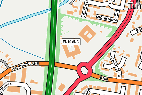
EN10 6NG is located in the Wormley and Turnford electoral ward, within the local authority district of Broxbourne and the English Parliamentary constituency of Broxbourne. The Sub Integrated Care Board (ICB) Location is NHS Hertfordshire and West Essex ICB - 06K and the police force is Hertfordshire. This postcode has been in use since August 1992.


GetTheData
Source: OS OpenMap – Local (Ordnance Survey)
Source: OS VectorMap District (Ordnance Survey)
Licence: Open Government Licence (requires attribution)
| Easting | 536007 |
| Northing | 204287 |
| Latitude | 51.720822 |
| Longitude | -0.032443 |
GetTheData
Source: Open Postcode Geo
Licence: Open Government Licence
| Country | England |
| Postcode District | EN10 |
➜ See where EN10 is on a map ➜ Where is Hoddesdon? | |
GetTheData
Source: Land Registry Price Paid Data
Licence: Open Government Licence
Elevation or altitude of EN10 6NG as distance above sea level:
| Metres | Feet | |
|---|---|---|
| Elevation | 30m | 98ft |
Elevation is measured from the approximate centre of the postcode, to the nearest point on an OS contour line from OS Terrain 50, which has contour spacing of ten vertical metres.
➜ How high above sea level am I? Find the elevation of your current position using your device's GPS.
GetTheData
Source: Open Postcode Elevation
Licence: Open Government Licence
| Ward | Wormley And Turnford |
| Constituency | Broxbourne |
GetTheData
Source: ONS Postcode Database
Licence: Open Government Licence
| Canada Fields (Vancouver Road) | Turnford | 344m |
| Thomas Rochford Way (High Road) | Turnford | 460m |
| Thomas Rochford Way (High Road) | Turnford | 472m |
| Brookfield Centre | Cheshunt | 494m |
| Bulls Head Ph (High Road) | Turnford | 497m |
| Cheshunt Station | 2.1km |
| Theobalds Grove Station | 3.2km |
| Broxbourne Station | 3.3km |
GetTheData
Source: NaPTAN
Licence: Open Government Licence
GetTheData
Source: ONS Postcode Database
Licence: Open Government Licence


➜ Get more ratings from the Food Standards Agency
GetTheData
Source: Food Standards Agency
Licence: FSA terms & conditions
| Last Collection | |||
|---|---|---|---|
| Location | Mon-Fri | Sat | Distance |
| Groom Road | 18:00 | 11:30 | 513m |
| East Herts College | 18:00 | 11:30 | 714m |
| The Links/Brookfield Farm | 17:30 | 11:30 | 1,065m |
GetTheData
Source: Dracos
Licence: Creative Commons Attribution-ShareAlike
The below table lists the International Territorial Level (ITL) codes (formerly Nomenclature of Territorial Units for Statistics (NUTS) codes) and Local Administrative Units (LAU) codes for EN10 6NG:
| ITL 1 Code | Name |
|---|---|
| TLH | East |
| ITL 2 Code | Name |
| TLH2 | Bedfordshire and Hertfordshire |
| ITL 3 Code | Name |
| TLH23 | Hertfordshire CC |
| LAU 1 Code | Name |
| E07000095 | Broxbourne |
GetTheData
Source: ONS Postcode Directory
Licence: Open Government Licence
The below table lists the Census Output Area (OA), Lower Layer Super Output Area (LSOA), and Middle Layer Super Output Area (MSOA) for EN10 6NG:
| Code | Name | |
|---|---|---|
| OA | E00118601 | |
| LSOA | E01023344 | Broxbourne 005E |
| MSOA | E02004847 | Broxbourne 005 |
GetTheData
Source: ONS Postcode Directory
Licence: Open Government Licence
| EN10 6FT | Huron Road | 182m |
| EN10 6FY | Michigan Close | 188m |
| EN10 6FZ | Michigan Close | 196m |
| EN10 6LR | Hollyfields | 198m |
| EN8 0TF | Perrysfield Road | 212m |
| EN10 6FU | Huron Road | 241m |
| EN8 0TN | Perrysfield Road | 254m |
| EN10 6FS | Columbia Road | 265m |
| EN8 0TJ | Perrysfield Road | 270m |
| EN8 0TL | Perrysfield Road | 277m |
GetTheData
Source: Open Postcode Geo; Land Registry Price Paid Data
Licence: Open Government Licence