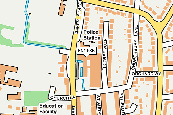
EN1 9SB is located in the Town electoral ward, within the London borough of Enfield and the English Parliamentary constituency of Enfield North. The Sub Integrated Care Board (ICB) Location is NHS North Central London ICB - 93C and the police force is Metropolitan Police. This postcode has been in use since February 2005.


GetTheData
Source: OS OpenMap – Local (Ordnance Survey)
Source: OS VectorMap District (Ordnance Survey)
Licence: Open Government Licence (requires attribution)
| Easting | 532922 |
| Northing | 196870 |
| Latitude | 51.654911 |
| Longitude | -0.079899 |
GetTheData
Source: Open Postcode Geo
Licence: Open Government Licence
| Country | England |
| Postcode District | EN1 |
➜ See where EN1 is on a map ➜ Where is London? | |
GetTheData
Source: Land Registry Price Paid Data
Licence: Open Government Licence
Elevation or altitude of EN1 9SB as distance above sea level:
| Metres | Feet | |
|---|---|---|
| Elevation | 30m | 98ft |
Elevation is measured from the approximate centre of the postcode, to the nearest point on an OS contour line from OS Terrain 50, which has contour spacing of ten vertical metres.
➜ How high above sea level am I? Find the elevation of your current position using your device's GPS.
GetTheData
Source: Open Postcode Elevation
Licence: Open Government Licence
| Ward | Town |
| Constituency | Enfield North |
GetTheData
Source: ONS Postcode Database
Licence: Open Government Licence
| Enfield Police Station (Baker Street) | Enfield Town | 60m |
| Enfield Civic Centre (Silver Street) | Enfield Town | 124m |
| Enfield Police Station (Baker Street) | Enfield Town | 135m |
| Enfield Civic Centre (Silver Street) | Enfield Town | 229m |
| Willow Road Parsonage Lane | Enfield Town | 246m |
| Enfield Town Station | 0.3km |
| Enfield Chase Station | 0.8km |
| Gordon Hill Station | 1.4km |
GetTheData
Source: NaPTAN
Licence: Open Government Licence
GetTheData
Source: ONS Postcode Database
Licence: Open Government Licence


➜ Get more ratings from the Food Standards Agency
GetTheData
Source: Food Standards Agency
Licence: FSA terms & conditions
| Last Collection | |||
|---|---|---|---|
| Location | Mon-Fri | Sat | Distance |
| Willow Road | 17:30 | 12:00 | 254m |
| London Road P.o. | 18:30 | 12:00 | 290m |
| Town Station | 19:00 | 12:00 | 297m |
GetTheData
Source: Dracos
Licence: Creative Commons Attribution-ShareAlike
The below table lists the International Territorial Level (ITL) codes (formerly Nomenclature of Territorial Units for Statistics (NUTS) codes) and Local Administrative Units (LAU) codes for EN1 9SB:
| ITL 1 Code | Name |
|---|---|
| TLI | London |
| ITL 2 Code | Name |
| TLI5 | Outer London - East and North East |
| ITL 3 Code | Name |
| TLI54 | Enfield |
| LAU 1 Code | Name |
| E09000010 | Enfield |
GetTheData
Source: ONS Postcode Directory
Licence: Open Government Licence
The below table lists the Census Output Area (OA), Lower Layer Super Output Area (LSOA), and Middle Layer Super Output Area (MSOA) for EN1 9SB:
| Code | Name | |
|---|---|---|
| OA | E00007657 | |
| LSOA | E01001544 | Enfield 009D |
| MSOA | E02000285 | Enfield 009 |
GetTheData
Source: ONS Postcode Directory
Licence: Open Government Licence
| EN1 3ET | Baker Street | 75m |
| EN1 3TZ | Firtree Walk | 91m |
| EN1 3EB | Silver Street | 107m |
| EN1 3EU | Baker Street | 131m |
| EN1 3TY | Churchbury Lane | 152m |
| EN1 3TD | Silver Street | 178m |
| EN1 3UJ | Parsonage Lane | 179m |
| EN1 3TU | Churchbury Lane | 187m |
| EN1 3TT | Fyfield Road | 190m |
| EN1 3TX | Churchbury Lane | 191m |
GetTheData
Source: Open Postcode Geo; Land Registry Price Paid Data
Licence: Open Government Licence