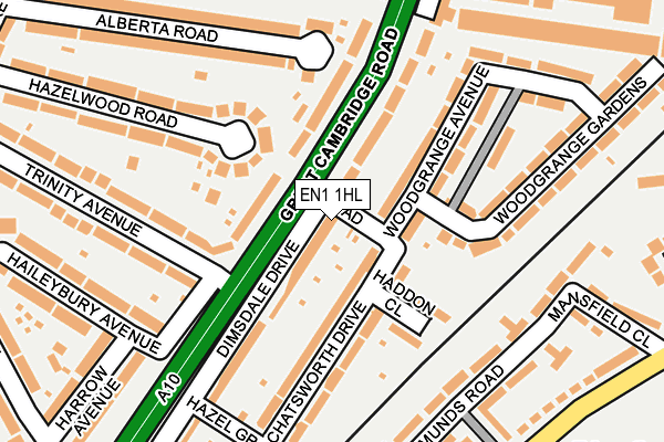
EN1 1HL is located in the Jubilee electoral ward, within the London borough of Enfield and the English Parliamentary constituency of Edmonton. The Sub Integrated Care Board (ICB) Location is NHS North Central London ICB - 93C and the police force is Metropolitan Police. This postcode has been in use since April 2006.


GetTheData
Source: OS OpenMap – Local (Ordnance Survey)
Source: OS VectorMap District (Ordnance Survey)
Licence: Open Government Licence (requires attribution)
| Easting | 534191 |
| Northing | 195280 |
| Latitude | 51.640322 |
| Longitude | -0.062176 |
GetTheData
Source: Open Postcode Geo
Licence: Open Government Licence
| Country | England |
| Postcode District | EN1 |
➜ See where EN1 is on a map ➜ Where is London? | |
GetTheData
Source: Land Registry Price Paid Data
Licence: Open Government Licence
Elevation or altitude of EN1 1HL as distance above sea level:
| Metres | Feet | |
|---|---|---|
| Elevation | 20m | 66ft |
Elevation is measured from the approximate centre of the postcode, to the nearest point on an OS contour line from OS Terrain 50, which has contour spacing of ten vertical metres.
➜ How high above sea level am I? Find the elevation of your current position using your device's GPS.
GetTheData
Source: Open Postcode Elevation
Licence: Open Government Licence
| Ward | Jubilee |
| Constituency | Edmonton |
GetTheData
Source: ONS Postcode Database
Licence: Open Government Licence
| Trinity Avenuebush Hill Park (Great Cambridge Road) | Bush Hill Park | 47m |
| Trinity Avenuebush Hill Park | Bush Hill Park | 84m |
| Trinity Avenue Bush Hill Park | Bush Hill Park | 155m |
| Trinity Avenuebush Hill Park | Bush Hill Park | 243m |
| Ladbroke Road Bush Hill Park | Bush Hill Park | 314m |
| Bush Hill Park Station | 0.5km |
| Southbury Station | 1.2km |
| Edmonton Green Station | 1.7km |
GetTheData
Source: NaPTAN
Licence: Open Government Licence
| Percentage of properties with Next Generation Access | 100.0% |
| Percentage of properties with Superfast Broadband | 100.0% |
| Percentage of properties with Ultrafast Broadband | 100.0% |
| Percentage of properties with Full Fibre Broadband | 0.0% |
Superfast Broadband is between 30Mbps and 300Mbps
Ultrafast Broadband is > 300Mbps
| Percentage of properties unable to receive 2Mbps | 0.0% |
| Percentage of properties unable to receive 5Mbps | 0.0% |
| Percentage of properties unable to receive 10Mbps | 0.0% |
| Percentage of properties unable to receive 30Mbps | 0.0% |
GetTheData
Source: Ofcom
Licence: Ofcom Terms of Use (requires attribution)
GetTheData
Source: ONS Postcode Database
Licence: Open Government Licence

➜ Get more ratings from the Food Standards Agency
GetTheData
Source: Food Standards Agency
Licence: FSA terms & conditions
| Last Collection | |||
|---|---|---|---|
| Location | Mon-Fri | Sat | Distance |
| Trinity Avenue | 17:30 | 12:00 | 106m |
| Chatsworth Drive | 17:30 | 12:00 | 191m |
| Lynmouth Avenue | 17:30 | 12:00 | 434m |
GetTheData
Source: Dracos
Licence: Creative Commons Attribution-ShareAlike
The below table lists the International Territorial Level (ITL) codes (formerly Nomenclature of Territorial Units for Statistics (NUTS) codes) and Local Administrative Units (LAU) codes for EN1 1HL:
| ITL 1 Code | Name |
|---|---|
| TLI | London |
| ITL 2 Code | Name |
| TLI5 | Outer London - East and North East |
| ITL 3 Code | Name |
| TLI54 | Enfield |
| LAU 1 Code | Name |
| E09000010 | Enfield |
GetTheData
Source: ONS Postcode Directory
Licence: Open Government Licence
The below table lists the Census Output Area (OA), Lower Layer Super Output Area (LSOA), and Middle Layer Super Output Area (MSOA) for EN1 1HL:
| Code | Name | |
|---|---|---|
| OA | E00007358 | |
| LSOA | E01001478 | Enfield 016B |
| MSOA | E02000292 | Enfield 016 |
GetTheData
Source: ONS Postcode Directory
Licence: Open Government Licence
| EN1 1EP | Woodgrange Avenue | 52m |
| EN1 1EX | Chatsworth Drive | 62m |
| EN1 1JE | Woodgrange Terrace | 84m |
| EN1 1HE | Dimsdale Drive | 93m |
| EN1 1EL | Orchard Terrace | 106m |
| EN1 1ET | Haddon Close | 115m |
| EN1 1EW | Woodgrange Avenue | 137m |
| EN1 1EY | Chatsworth Drive | 142m |
| EN1 1ES | Woodgrange Gardens | 142m |
| EN1 1JQ | Hazelwood Road | 201m |
GetTheData
Source: Open Postcode Geo; Land Registry Price Paid Data
Licence: Open Government Licence