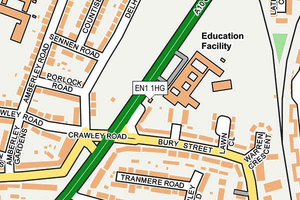
EN1 1HG is located in the Haselbury electoral ward, within the London borough of Enfield and the English Parliamentary constituency of Edmonton. The Sub Integrated Care Board (ICB) Location is NHS North Central London ICB - 93C and the police force is Metropolitan Police. This postcode has been in use since January 1991.


GetTheData
Source: OS OpenMap – Local (Ordnance Survey)
Source: OS VectorMap District (Ordnance Survey)
Licence: Open Government Licence (requires attribution)
| Easting | 533756 |
| Northing | 194671 |
| Latitude | 51.634953 |
| Longitude | -0.068691 |
GetTheData
Source: Open Postcode Geo
Licence: Open Government Licence
| Country | England |
| Postcode District | EN1 |
➜ See where EN1 is on a map ➜ Where is London? | |
GetTheData
Source: Land Registry Price Paid Data
Licence: Open Government Licence
Elevation or altitude of EN1 1HG as distance above sea level:
| Metres | Feet | |
|---|---|---|
| Elevation | 20m | 66ft |
Elevation is measured from the approximate centre of the postcode, to the nearest point on an OS contour line from OS Terrain 50, which has contour spacing of ten vertical metres.
➜ How high above sea level am I? Find the elevation of your current position using your device's GPS.
GetTheData
Source: Open Postcode Elevation
Licence: Open Government Licence
| Ward | Haselbury |
| Constituency | Edmonton |
GetTheData
Source: ONS Postcode Database
Licence: Open Government Licence
| Bury Street Great Cambridge Road (Great Cambridge Road) | Bush Hill Park | 53m |
| Bury Street Great Cambridge Road | Bush Hill Park | 85m |
| Bury Street Great Cambridge Road | Bush Hill Park | 179m |
| Bury Street Great Cambridge Road (Great Cambridge Road) | Bush Hill Park | 201m |
| Bury Street Lower Edmonton | Lower Edmonton | 209m |
| Bush Hill Park Station | 0.7km |
| Edmonton Green Station | 1.2km |
| Southbury Station | 1.9km |
GetTheData
Source: NaPTAN
Licence: Open Government Licence
GetTheData
Source: ONS Postcode Database
Licence: Open Government Licence


➜ Get more ratings from the Food Standards Agency
GetTheData
Source: Food Standards Agency
Licence: FSA terms & conditions
| Last Collection | |||
|---|---|---|---|
| Location | Mon-Fri | Sat | Distance |
| Lynmouth Avenue | 17:30 | 12:00 | 395m |
| Ash Grove | 17:30 | 12:00 | 414m |
| Galliard Road/St Edmunds Road | 17:30 | 12:00 | 446m |
GetTheData
Source: Dracos
Licence: Creative Commons Attribution-ShareAlike
The below table lists the International Territorial Level (ITL) codes (formerly Nomenclature of Territorial Units for Statistics (NUTS) codes) and Local Administrative Units (LAU) codes for EN1 1HG:
| ITL 1 Code | Name |
|---|---|
| TLI | London |
| ITL 2 Code | Name |
| TLI5 | Outer London - East and North East |
| ITL 3 Code | Name |
| TLI54 | Enfield |
| LAU 1 Code | Name |
| E09000010 | Enfield |
GetTheData
Source: ONS Postcode Directory
Licence: Open Government Licence
The below table lists the Census Output Area (OA), Lower Layer Super Output Area (LSOA), and Middle Layer Super Output Area (MSOA) for EN1 1HG:
| Code | Name | |
|---|---|---|
| OA | E00007372 | |
| LSOA | E01001480 | Enfield 024D |
| MSOA | E02000300 | Enfield 024 |
GetTheData
Source: ONS Postcode Directory
Licence: Open Government Licence
| EN1 1HH | Winifred Terrace | 38m |
| N9 9JH | Edward Close | 76m |
| N9 9JG | Bury Street | 105m |
| N9 9LG | Bury Street | 105m |
| EN1 2NA | Delhi Road | 139m |
| EN1 2NB | Delhi Road | 147m |
| N9 9EJ | Tranmere Road | 151m |
| N9 9JQ | Lawn Close | 171m |
| N9 9EL | Tranmere Road | 175m |
| N9 9LF | Bury Hall Villas | 177m |
GetTheData
Source: Open Postcode Geo; Land Registry Price Paid Data
Licence: Open Government Licence