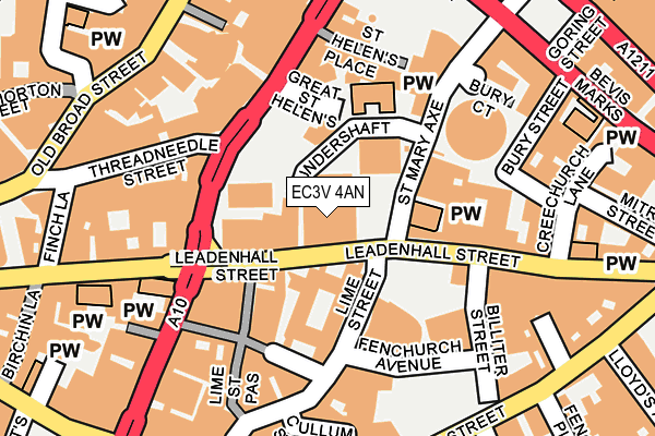
EC3V 4AN is located in the Lime Street electoral ward, within the London borough of City of London and the English Parliamentary constituency of Cities of London and Westminster. The Sub Integrated Care Board (ICB) Location is NHS North East London ICB - A3A8R and the police force is City of London. This postcode has been in use since September 2015.


GetTheData
Source: OS OpenMap – Local (Ordnance Survey)
Source: OS VectorMap District (Ordnance Survey)
Licence: Open Government Licence (requires attribution)
| Easting | 533165 |
| Northing | 181170 |
| Latitude | 51.513769 |
| Longitude | -0.082338 |
GetTheData
Source: Open Postcode Geo
Licence: Open Government Licence
| Country | England |
| Postcode District | EC3V |
➜ See where EC3V is on a map ➜ Where is City of London? | |
GetTheData
Source: Land Registry Price Paid Data
Licence: Open Government Licence
Elevation or altitude of EC3V 4AN as distance above sea level:
| Metres | Feet | |
|---|---|---|
| Elevation | 10m | 33ft |
Elevation is measured from the approximate centre of the postcode, to the nearest point on an OS contour line from OS Terrain 50, which has contour spacing of ten vertical metres.
➜ How high above sea level am I? Find the elevation of your current position using your device's GPS.
GetTheData
Source: Open Postcode Elevation
Licence: Open Government Licence
| Ward | Lime Street |
| Constituency | Cities Of London And Westminster |
GetTheData
Source: ONS Postcode Database
Licence: Open Government Licence
| St Mary Axe | City Of London | 40m |
| St Mary Axe | City Of London | 46m |
| Threadneedle Street | City Of London | 106m |
| Threadneedle Street | City Of London | 118m |
| Bishopsgate City Of London (Cornhill) | City Of London | 186m |
| Liverpool Street Underground Station | Liverpool Street | 405m |
| Monument Underground Station | Monument | 424m |
| Bank Dlr Station (Cornhill) | Bank | 433m |
| Bank Underground Station | Bank | 461m |
| Aldgate Underground Station | Aldgate | 465m |
| London Fenchurch Street Station | 0.3km |
| London Liverpool Street Station | 0.5km |
| London Cannon Street Station | 0.6km |
GetTheData
Source: NaPTAN
Licence: Open Government Licence
GetTheData
Source: ONS Postcode Database
Licence: Open Government Licence


➜ Get more ratings from the Food Standards Agency
GetTheData
Source: Food Standards Agency
Licence: FSA terms & conditions
| Last Collection | |||
|---|---|---|---|
| Location | Mon-Fri | Sat | Distance |
| Leadenhall Street | 18:30 | 12:00 | 53m |
| Leadenhall Street (St Mary Axe | 18:30 | 56m | |
| Lloyds Building (Lime Street) | 18:30 | 12:00 | 131m |
GetTheData
Source: Dracos
Licence: Creative Commons Attribution-ShareAlike
The below table lists the International Territorial Level (ITL) codes (formerly Nomenclature of Territorial Units for Statistics (NUTS) codes) and Local Administrative Units (LAU) codes for EC3V 4AN:
| ITL 1 Code | Name |
|---|---|
| TLI | London |
| ITL 2 Code | Name |
| TLI3 | Inner London - West |
| ITL 3 Code | Name |
| TLI31 | Camden and City of London |
| LAU 1 Code | Name |
| E09000001 | City of London |
GetTheData
Source: ONS Postcode Directory
Licence: Open Government Licence
The below table lists the Census Output Area (OA), Lower Layer Super Output Area (LSOA), and Middle Layer Super Output Area (MSOA) for EC3V 4AN:
| Code | Name | |
|---|---|---|
| OA | E00000035 | |
| LSOA | E01032739 | City of London 001F |
| MSOA | E02000001 | City of London 001 |
GetTheData
Source: ONS Postcode Directory
Licence: Open Government Licence
| EC3V 4QT | Leadenhall Street | 54m |
| EC3V 1LP | Leadenhall Street | 65m |
| EC3A 4AF | Leadenhall Street | 109m |
| EC3A 4AA | Leadenhall Street | 127m |
| EC2N 4AJ | Bishopsgate | 142m |
| EC2N 4AW | Bishopsgate | 152m |
| EC3V 3PD | Cornhill | 176m |
| EC3V 1LT | Leadenhall Market | 179m |
| EC3V 1LU | Bulls Head Passage | 187m |
| EC3M 7HT | Lime Street | 191m |
GetTheData
Source: Open Postcode Geo; Land Registry Price Paid Data
Licence: Open Government Licence