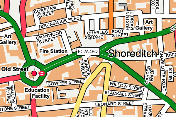
EC2A 4BQ is located in the Hoxton East & Shoreditch electoral ward, within the London borough of Hackney and the English Parliamentary constituency of Hackney South and Shoreditch. The Sub Integrated Care Board (ICB) Location is NHS North East London ICB - A3A8R and the police force is Metropolitan Police. This postcode has been in use since January 1980.


GetTheData
Source: OS OpenMap – Local (Ordnance Survey)
Source: OS VectorMap District (Ordnance Survey)
Licence: Open Government Licence (requires attribution)
| Easting | 532957 |
| Northing | 182534 |
| Latitude | 51.526077 |
| Longitude | -0.084794 |
GetTheData
Source: Open Postcode Geo
Licence: Open Government Licence
| Country | England |
| Postcode District | EC2A |
➜ See where EC2A is on a map ➜ Where is London? | |
GetTheData
Source: Land Registry Price Paid Data
Licence: Open Government Licence
Elevation or altitude of EC2A 4BQ as distance above sea level:
| Metres | Feet | |
|---|---|---|
| Elevation | 20m | 66ft |
Elevation is measured from the approximate centre of the postcode, to the nearest point on an OS contour line from OS Terrain 50, which has contour spacing of ten vertical metres.
➜ How high above sea level am I? Find the elevation of your current position using your device's GPS.
GetTheData
Source: Open Postcode Elevation
Licence: Open Government Licence
| Ward | Hoxton East & Shoreditch |
| Constituency | Hackney South And Shoreditch |
GetTheData
Source: ONS Postcode Database
Licence: Open Government Licence
| Old Street | Old Street | 89m |
| Shoreditch Fire Station | Shoreditch | 90m |
| Great Eastern Street (Old Street) | Shoreditch | 119m |
| Pitfield St Great Eastern St | Shoreditch | 121m |
| Ravey Street (Great Eastern Street) | Shoreditch | 178m |
| Old Street Underground Station | Old Street | 206m |
| Moorgate Underground Station | Moorgate | 912m |
| Liverpool Street Underground Station | Liverpool Street | 975m |
| Barbican Underground Station | Barbican | 1,119m |
| Bank Underground Station | Bank | 1,437m |
| Old Street Station | 0.3km |
| Shoreditch High Street Station | 0.7km |
| Hoxton Station | 0.9km |
GetTheData
Source: NaPTAN
Licence: Open Government Licence
GetTheData
Source: ONS Postcode Database
Licence: Open Government Licence


➜ Get more ratings from the Food Standards Agency
GetTheData
Source: Food Standards Agency
Licence: FSA terms & conditions
| Last Collection | |||
|---|---|---|---|
| Location | Mon-Fri | Sat | Distance |
| Charles Square | 18:30 | 12:00 | 143m |
| Gt Eastern Street (Leonard St) | 18:30 | 287m | |
| Gt Eastern Street (Leonard St) | 18:30 | 12:00 | 290m |
GetTheData
Source: Dracos
Licence: Creative Commons Attribution-ShareAlike
The below table lists the International Territorial Level (ITL) codes (formerly Nomenclature of Territorial Units for Statistics (NUTS) codes) and Local Administrative Units (LAU) codes for EC2A 4BQ:
| ITL 1 Code | Name |
|---|---|
| TLI | London |
| ITL 2 Code | Name |
| TLI4 | Inner London - East |
| ITL 3 Code | Name |
| TLI41 | Hackney and Newham |
| LAU 1 Code | Name |
| E09000012 | Hackney |
GetTheData
Source: ONS Postcode Directory
Licence: Open Government Licence
The below table lists the Census Output Area (OA), Lower Layer Super Output Area (LSOA), and Middle Layer Super Output Area (MSOA) for EC2A 4BQ:
| Code | Name | |
|---|---|---|
| OA | E00176275 | |
| LSOA | E01033708 | Hackney 027G |
| MSOA | E02000371 | Hackney 027 |
GetTheData
Source: ONS Postcode Directory
Licence: Open Government Licence
| EC2A 3JD | Great Eastern Street | 23m |
| EC1V 9DD | Old Street | 33m |
| EC2A 4AP | Cowper Street | 65m |
| N1 6HN | Charles Square Estate | 73m |
| EC2A 4NY | Paul Street | 80m |
| EC2A 4LE | Tabernacle Street | 82m |
| N1 6HL | Charles Square | 85m |
| EC2A 4NQ | Paul Street | 91m |
| EC2A 4NE | Paul Street | 97m |
| EC1V 9HE | Old Street | 103m |
GetTheData
Source: Open Postcode Geo; Land Registry Price Paid Data
Licence: Open Government Licence