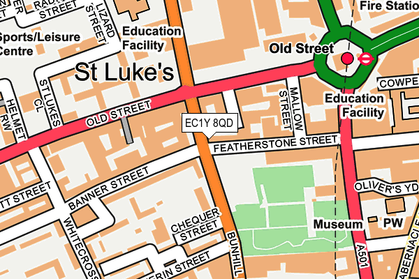
EC1Y 8QD is located in the Bunhill electoral ward, within the London borough of Islington and the English Parliamentary constituency of Islington South and Finsbury. The Sub Integrated Care Board (ICB) Location is NHS North Central London ICB - 93C and the police force is Metropolitan Police. This postcode has been in use since October 1985.


GetTheData
Source: OS OpenMap – Local (Ordnance Survey)
Source: OS VectorMap District (Ordnance Survey)
Licence: Open Government Licence (requires attribution)
| Easting | 532570 |
| Northing | 182383 |
| Latitude | 51.524811 |
| Longitude | -0.090426 |
GetTheData
Source: Open Postcode Geo
Licence: Open Government Licence
| Country | England |
| Postcode District | EC1Y |
➜ See where EC1Y is on a map ➜ Where is London? | |
GetTheData
Source: Land Registry Price Paid Data
Licence: Open Government Licence
Elevation or altitude of EC1Y 8QD as distance above sea level:
| Metres | Feet | |
|---|---|---|
| Elevation | 20m | 66ft |
Elevation is measured from the approximate centre of the postcode, to the nearest point on an OS contour line from OS Terrain 50, which has contour spacing of ten vertical metres.
➜ How high above sea level am I? Find the elevation of your current position using your device's GPS.
GetTheData
Source: Open Postcode Elevation
Licence: Open Government Licence
| Ward | Bunhill |
| Constituency | Islington South And Finsbury |
GetTheData
Source: ONS Postcode Database
Licence: Open Government Licence
| Featherstone Street | Old Street | 17m |
| Bunhill Row | Old Street | 92m |
| Old Street | Old Street | 139m |
| St Luke's Music Edu Centre (Old Street) | St Luke's | 189m |
| Dufferin Street | St Luke's | 203m |
| Old Street Underground Station | Old Street | 220m |
| Barbican Underground Station | Barbican | 727m |
| Moorgate Underground Station | Moorgate | 753m |
| Liverpool Street Underground Station | Liverpool Street | 969m |
| Farringdon Underground Station | Farringdon | 1,124m |
| Old Street Station | 0.2km |
| Moorgate Station | 0.7km |
| London Liverpool Street Station | 1km |
GetTheData
Source: NaPTAN
Licence: Open Government Licence
Estimated total energy consumption in EC1Y 8QD by fuel type, 2015.
| Consumption (kWh) | 214,470 |
|---|---|
| Meter count | 24 |
| Mean (kWh/meter) | 8,936 |
| Median (kWh/meter) | 8,579 |
GetTheData
Source: Postcode level gas estimates: 2015 (experimental)
Source: Postcode level electricity estimates: 2015 (experimental)
Licence: Open Government Licence
GetTheData
Source: ONS Postcode Database
Licence: Open Government Licence


➜ Get more ratings from the Food Standards Agency
GetTheData
Source: Food Standards Agency
Licence: FSA terms & conditions
| Last Collection | |||
|---|---|---|---|
| Location | Mon-Fri | Sat | Distance |
| Old Street Branch Office | 18:30 | 12:00 | 131m |
| Bunhill Row (O/S 109) | 18:30 | 12:00 | 145m |
| Old Street (Golden Lane) | 18:30 | 12:00 | 312m |
GetTheData
Source: Dracos
Licence: Creative Commons Attribution-ShareAlike
The below table lists the International Territorial Level (ITL) codes (formerly Nomenclature of Territorial Units for Statistics (NUTS) codes) and Local Administrative Units (LAU) codes for EC1Y 8QD:
| ITL 1 Code | Name |
|---|---|
| TLI | London |
| ITL 2 Code | Name |
| TLI4 | Inner London - East |
| ITL 3 Code | Name |
| TLI43 | Haringey and Islington |
| LAU 1 Code | Name |
| E09000019 | Islington |
GetTheData
Source: ONS Postcode Directory
Licence: Open Government Licence
The below table lists the Census Output Area (OA), Lower Layer Super Output Area (LSOA), and Middle Layer Super Output Area (MSOA) for EC1Y 8QD:
| Code | Name | |
|---|---|---|
| OA | E00013455 | |
| LSOA | E01002704 | Islington 023D |
| MSOA | E02000576 | Islington 023 |
GetTheData
Source: ONS Postcode Directory
Licence: Open Government Licence
| EC1Y 8QW | Bunhill Row | 5m |
| EC1Y 8RZ | Featherstone Street | 29m |
| EC1Y 8RT | Featherstone Street | 54m |
| EC1V 9FL | Marthas Buildings | 61m |
| EC1Y 8NE | Bunhill Row | 89m |
| EC1Y 8NQ | Bunhill Row | 89m |
| EC1V 9NS | Old Street | 94m |
| EC1Y 8SL | Featherstone Street | 96m |
| EC1V 9BS | Old Street | 109m |
| EC1V 9BQ | Tilney Court | 119m |
GetTheData
Source: Open Postcode Geo; Land Registry Price Paid Data
Licence: Open Government Licence