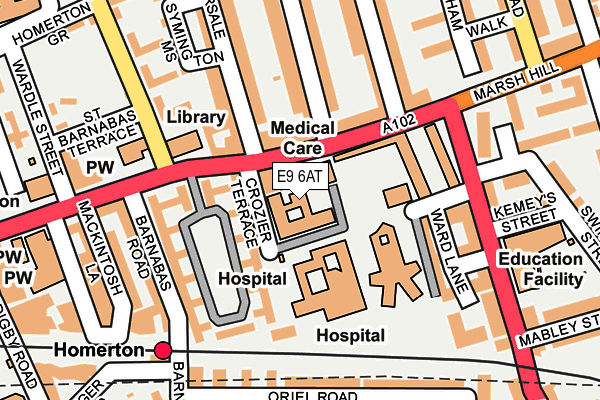
E9 6AT is located in the Hackney Wick electoral ward, within the London borough of Hackney and the English Parliamentary constituency of Hackney South and Shoreditch. The Sub Integrated Care Board (ICB) Location is NHS North East London ICB - A3A8R and the police force is Metropolitan Police. This postcode has been in use since December 1997.


GetTheData
Source: OS OpenMap – Local (Ordnance Survey)
Source: OS VectorMap District (Ordnance Survey)
Licence: Open Government Licence (requires attribution)
| Easting | 535986 |
| Northing | 185096 |
| Latitude | 51.548377 |
| Longitude | -0.040195 |
GetTheData
Source: Open Postcode Geo
Licence: Open Government Licence
| Country | England |
| Postcode District | E9 |
➜ See where E9 is on a map ➜ Where is Hackney? | |
GetTheData
Source: Land Registry Price Paid Data
Licence: Open Government Licence
Elevation or altitude of E9 6AT as distance above sea level:
| Metres | Feet | |
|---|---|---|
| Elevation | 10m | 33ft |
Elevation is measured from the approximate centre of the postcode, to the nearest point on an OS contour line from OS Terrain 50, which has contour spacing of ten vertical metres.
➜ How high above sea level am I? Find the elevation of your current position using your device's GPS.
GetTheData
Source: Open Postcode Elevation
Licence: Open Government Licence
| Ward | Hackney Wick |
| Constituency | Hackney South And Shoreditch |
GetTheData
Source: ONS Postcode Database
Licence: Open Government Licence
| Glyn Road (Homerton High Street) | Homerton | 55m |
| Glyn Road (Homerton High Street) | Homerton | 60m |
| Ickburgh School (Kenworthy Road) | Homerton | 165m |
| Ickburgh School (Kenworthy Road) | Homerton | 205m |
| Brooksby's Walk Homerton Station | Homerton | 220m |
| Homerton Station | 0.2km |
| Hackney Central Station | 1.1km |
| Hackney Wick Station | 1.2km |
GetTheData
Source: NaPTAN
Licence: Open Government Licence
GetTheData
Source: ONS Postcode Database
Licence: Open Government Licence


➜ Get more ratings from the Food Standards Agency
GetTheData
Source: Food Standards Agency
Licence: FSA terms & conditions
| Last Collection | |||
|---|---|---|---|
| Location | Mon-Fri | Sat | Distance |
| 226 Homerton High Street | 18:30 | 12:00 | 33m |
| 226 Homerton High Street E9 | 17:00 | 12:00 | 37m |
| Barnabas Road | 17:00 | 11:30 | 273m |
GetTheData
Source: Dracos
Licence: Creative Commons Attribution-ShareAlike
The below table lists the International Territorial Level (ITL) codes (formerly Nomenclature of Territorial Units for Statistics (NUTS) codes) and Local Administrative Units (LAU) codes for E9 6AT:
| ITL 1 Code | Name |
|---|---|
| TLI | London |
| ITL 2 Code | Name |
| TLI4 | Inner London - East |
| ITL 3 Code | Name |
| TLI41 | Hackney and Newham |
| LAU 1 Code | Name |
| E09000012 | Hackney |
GetTheData
Source: ONS Postcode Directory
Licence: Open Government Licence
The below table lists the Census Output Area (OA), Lower Layer Super Output Area (LSOA), and Middle Layer Super Output Area (MSOA) for E9 6AT:
| Code | Name | |
|---|---|---|
| OA | E00009205 | |
| LSOA | E01001848 | Hackney 018C |
| MSOA | E02000362 | Hackney 018 |
GetTheData
Source: ONS Postcode Directory
Licence: Open Government Licence
| E9 6AS | Homerton High Street | 64m |
| E9 6BB | Homerton High Street | 117m |
| E9 6AJ | Homerton High Street | 121m |
| E9 6AL | Homerton High Street | 121m |
| E9 6AN | Homerton High Street | 121m |
| E9 5SA | Homerton High Street | 154m |
| E9 6AP | Homerton High Street | 154m |
| E9 6AR | Homerton High Street | 154m |
| E9 6AW | Homerton High Street | 154m |
| E9 5SB | Barnabas Road | 174m |
GetTheData
Source: Open Postcode Geo; Land Registry Price Paid Data
Licence: Open Government Licence