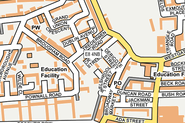
E8 4NB is located in the London Fields electoral ward, within the London borough of Hackney and the English Parliamentary constituency of Hackney South and Shoreditch. The Sub Integrated Care Board (ICB) Location is NHS North East London ICB - A3A8R and the police force is Metropolitan Police. This postcode has been in use since January 1992.


GetTheData
Source: OS OpenMap – Local (Ordnance Survey)
Source: OS VectorMap District (Ordnance Survey)
Licence: Open Government Licence (requires attribution)
| Easting | 534463 |
| Northing | 183849 |
| Latitude | 51.537536 |
| Longitude | -0.062623 |
GetTheData
Source: Open Postcode Geo
Licence: Open Government Licence
| Country | England |
| Postcode District | E8 |
➜ See where E8 is on a map ➜ Where is London? | |
GetTheData
Source: Land Registry Price Paid Data
Licence: Open Government Licence
Elevation or altitude of E8 4NB as distance above sea level:
| Metres | Feet | |
|---|---|---|
| Elevation | 20m | 66ft |
Elevation is measured from the approximate centre of the postcode, to the nearest point on an OS contour line from OS Terrain 50, which has contour spacing of ten vertical metres.
➜ How high above sea level am I? Find the elevation of your current position using your device's GPS.
GetTheData
Source: Open Postcode Elevation
Licence: Open Government Licence
| Ward | London Fields |
| Constituency | Hackney South And Shoreditch |
GetTheData
Source: ONS Postcode Database
Licence: Open Government Licence
| Trederwen Road | Haggerston | 56m |
| Trederwen Road | Haggerston | 89m |
| Broadway Market | Haggerston | 123m |
| Broadway Market | Haggerston | 145m |
| Laxfield Court (Pownall Road) | Haggerston | 195m |
| Bethnal Green Underground Station | Bethnal Green | 1,249m |
| London Fields Station | 0.5km |
| Cambridge Heath (London) Station | 0.7km |
| Haggerston Station | 0.9km |
GetTheData
Source: NaPTAN
Licence: Open Government Licence
GetTheData
Source: ONS Postcode Database
Licence: Open Government Licence


➜ Get more ratings from the Food Standards Agency
GetTheData
Source: Food Standards Agency
Licence: FSA terms & conditions
| Last Collection | |||
|---|---|---|---|
| Location | Mon-Fri | Sat | Distance |
| 39 Broadway Market E8 | 18:30 | 12:00 | 89m |
| Pownall Road | 18:30 | 11:30 | 215m |
| Shrubland Road | 18:30 | 11:30 | 271m |
GetTheData
Source: Dracos
Licence: Creative Commons Attribution-ShareAlike
The below table lists the International Territorial Level (ITL) codes (formerly Nomenclature of Territorial Units for Statistics (NUTS) codes) and Local Administrative Units (LAU) codes for E8 4NB:
| ITL 1 Code | Name |
|---|---|
| TLI | London |
| ITL 2 Code | Name |
| TLI4 | Inner London - East |
| ITL 3 Code | Name |
| TLI41 | Hackney and Newham |
| LAU 1 Code | Name |
| E09000012 | Hackney |
GetTheData
Source: ONS Postcode Directory
Licence: Open Government Licence
The below table lists the Census Output Area (OA), Lower Layer Super Output Area (LSOA), and Middle Layer Super Output Area (MSOA) for E8 4NB:
| Code | Name | |
|---|---|---|
| OA | E00009074 | |
| LSOA | E01001821 | Hackney 024F |
| MSOA | E02000368 | Hackney 024 |
GetTheData
Source: ONS Postcode Directory
Licence: Open Government Licence
| E8 4PQ | Croston Street | 41m |
| E8 4PG | Dericote Street | 51m |
| E8 4PE | Welshpool Street | 61m |
| E8 4PD | Brougham Road | 72m |
| E8 4TP | Dublin Avenue | 82m |
| E8 4NX | Benjamin Close | 97m |
| E8 4PH | Broadway Market | 100m |
| E8 4NE | Lansdowne Drive | 101m |
| E8 4QJ | Broadway Market | 127m |
| E8 4LJ | Stephan Close | 136m |
GetTheData
Source: Open Postcode Geo; Land Registry Price Paid Data
Licence: Open Government Licence