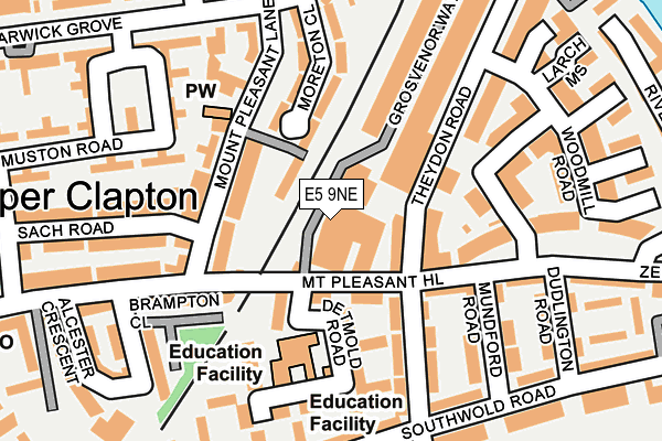
E5 9NE lies on Mount Pleasant Hill in London. E5 9NE is located in the Lea Bridge electoral ward, within the London borough of Hackney and the English Parliamentary constituency of Hackney North and Stoke Newington. The Sub Integrated Care Board (ICB) Location is NHS North East London ICB - A3A8R and the police force is Metropolitan Police. This postcode has been in use since January 1980.


GetTheData
Source: OS OpenMap – Local (Ordnance Survey)
Source: OS VectorMap District (Ordnance Survey)
Licence: Open Government Licence (requires attribution)
| Easting | 535032 |
| Northing | 186855 |
| Latitude | 51.564413 |
| Longitude | -0.053271 |
GetTheData
Source: Open Postcode Geo
Licence: Open Government Licence
| Street | Mount Pleasant Hill |
| Town/City | London |
| Country | England |
| Postcode District | E5 |
➜ See where E5 is on a map ➜ Where is London? | |
GetTheData
Source: Land Registry Price Paid Data
Licence: Open Government Licence
Elevation or altitude of E5 9NE as distance above sea level:
| Metres | Feet | |
|---|---|---|
| Elevation | 20m | 66ft |
Elevation is measured from the approximate centre of the postcode, to the nearest point on an OS contour line from OS Terrain 50, which has contour spacing of ten vertical metres.
➜ How high above sea level am I? Find the elevation of your current position using your device's GPS.
GetTheData
Source: Open Postcode Elevation
Licence: Open Government Licence
| Ward | Lea Bridge |
| Constituency | Hackney North And Stoke Newington |
GetTheData
Source: ONS Postcode Database
Licence: Open Government Licence
| Mount Pleasant Hill (Theydon Road) | Upper Clapton | 75m |
| Mount Pleasant Hill (Theydon Road) | Upper Clapton | 87m |
| Jack Watts Estate | Upper Clapton | 186m |
| Jack Watts Estate | Upper Clapton | 201m |
| Mount Pleasant Lane (Warwick Grove) | Upper Clapton | 209m |
| Clapton Station | 0.4km |
| Lea Bridge Station | 1.2km |
| Rectory Road Station | 1.2km |
GetTheData
Source: NaPTAN
Licence: Open Government Licence
GetTheData
Source: ONS Postcode Database
Licence: Open Government Licence


➜ Get more ratings from the Food Standards Agency
GetTheData
Source: Food Standards Agency
Licence: FSA terms & conditions
| Last Collection | |||
|---|---|---|---|
| Location | Mon-Fri | Sat | Distance |
| Sach Road | 17:00 | 11:30 | 113m |
| Elderfield Road | 17:00 | 11:30 | 217m |
| Southwold Road | 17:00 | 11:30 | 222m |
GetTheData
Source: Dracos
Licence: Creative Commons Attribution-ShareAlike
The below table lists the International Territorial Level (ITL) codes (formerly Nomenclature of Territorial Units for Statistics (NUTS) codes) and Local Administrative Units (LAU) codes for E5 9NE:
| ITL 1 Code | Name |
|---|---|
| TLI | London |
| ITL 2 Code | Name |
| TLI4 | Inner London - East |
| ITL 3 Code | Name |
| TLI41 | Hackney and Newham |
| LAU 1 Code | Name |
| E09000012 | Hackney |
GetTheData
Source: ONS Postcode Directory
Licence: Open Government Licence
The below table lists the Census Output Area (OA), Lower Layer Super Output Area (LSOA), and Middle Layer Super Output Area (MSOA) for E5 9NE:
| Code | Name | |
|---|---|---|
| OA | E00176246 | |
| LSOA | E01033702 | Hackney 028C |
| MSOA | E02006918 | Hackney 028 |
GetTheData
Source: ONS Postcode Directory
Licence: Open Government Licence
| E5 9NB | Mount Pleasant Hill | 33m |
| E5 9EW | Mount Pleasant Lane | 89m |
| E5 9NY | Theydon Road | 90m |
| E5 9NW | Inver Close | 119m |
| E5 9NA | Theydon Road | 124m |
| E5 9NF | Mount Pleasant Hill | 129m |
| E5 9LN | Warwick Grove | 132m |
| E5 9EP | Moreton Close | 132m |
| E5 9EN | Mount Pleasant Lane | 134m |
| E5 9GA | Woodmill Road | 134m |
GetTheData
Source: Open Postcode Geo; Land Registry Price Paid Data
Licence: Open Government Licence