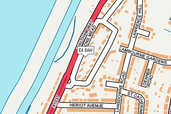
E4 8AH lies on Eatons Mead in London. E4 8AH is located in the Endlebury electoral ward, within the London borough of Waltham Forest and the English Parliamentary constituency of Chingford and Woodford Green. The Sub Integrated Care Board (ICB) Location is NHS North East London ICB - A3A8R and the police force is Metropolitan Police. This postcode has been in use since January 1980.


GetTheData
Source: OS OpenMap – Local (Ordnance Survey)
Source: OS VectorMap District (Ordnance Survey)
Licence: Open Government Licence (requires attribution)
| Easting | 537095 |
| Northing | 193786 |
| Latitude | 51.626197 |
| Longitude | -0.020821 |
GetTheData
Source: Open Postcode Geo
Licence: Open Government Licence
| Street | Eatons Mead |
| Town/City | London |
| Country | England |
| Postcode District | E4 |
➜ See where E4 is on a map ➜ Where is Chingford? | |
GetTheData
Source: Land Registry Price Paid Data
Licence: Open Government Licence
Elevation or altitude of E4 8AH as distance above sea level:
| Metres | Feet | |
|---|---|---|
| Elevation | 20m | 66ft |
Elevation is measured from the approximate centre of the postcode, to the nearest point on an OS contour line from OS Terrain 50, which has contour spacing of ten vertical metres.
➜ How high above sea level am I? Find the elevation of your current position using your device's GPS.
GetTheData
Source: Open Postcode Elevation
Licence: Open Government Licence
| Ward | Endlebury |
| Constituency | Chingford And Woodford Green |
GetTheData
Source: ONS Postcode Database
Licence: Open Government Licence
| Chingford Old Church (Old Church Road) | Chingford Mount | 410m |
| Ridgeway Park | Chingford Mount | 428m |
| Chingford Old Church (Old Church Road) | Chingford Mount | 455m |
| Ridgeway Park | Chingford Mount | 459m |
| Mansfield Park | Chingford | 577m |
| Ponders End Station | 2km |
| Chingford Station | 2.3km |
| Highams Park Station | 2.4km |
GetTheData
Source: NaPTAN
Licence: Open Government Licence
| Percentage of properties with Next Generation Access | 100.0% |
| Percentage of properties with Superfast Broadband | 100.0% |
| Percentage of properties with Ultrafast Broadband | 100.0% |
| Percentage of properties with Full Fibre Broadband | 0.0% |
Superfast Broadband is between 30Mbps and 300Mbps
Ultrafast Broadband is > 300Mbps
| Median download speed | 100.0Mbps |
| Average download speed | 116.4Mbps |
| Maximum download speed | 350.00Mbps |
| Median upload speed | 8.0Mbps |
| Average upload speed | 7.2Mbps |
| Maximum upload speed | 11.49Mbps |
| Percentage of properties unable to receive 2Mbps | 0.0% |
| Percentage of properties unable to receive 5Mbps | 0.0% |
| Percentage of properties unable to receive 10Mbps | 0.0% |
| Percentage of properties unable to receive 30Mbps | 0.0% |
GetTheData
Source: Ofcom
Licence: Ofcom Terms of Use (requires attribution)
Estimated total energy consumption in E4 8AH by fuel type, 2015.
| Consumption (kWh) | 205,039 |
|---|---|
| Meter count | 14 |
| Mean (kWh/meter) | 14,646 |
| Median (kWh/meter) | 14,909 |
| Consumption (kWh) | 54,202 |
|---|---|
| Meter count | 14 |
| Mean (kWh/meter) | 3,872 |
| Median (kWh/meter) | 3,554 |
GetTheData
Source: Postcode level gas estimates: 2015 (experimental)
Source: Postcode level electricity estimates: 2015 (experimental)
Licence: Open Government Licence
GetTheData
Source: ONS Postcode Database
Licence: Open Government Licence


➜ Get more ratings from the Food Standards Agency
GetTheData
Source: Food Standards Agency
Licence: FSA terms & conditions
| Last Collection | |||
|---|---|---|---|
| Location | Mon-Fri | Sat | Distance |
| Waltham Way | 17:30 | 11:30 | 201m |
| Valley Side | 17:30 | 11:30 | 295m |
| Wellington Avenue | 17:30 | 11:30 | 356m |
GetTheData
Source: Dracos
Licence: Creative Commons Attribution-ShareAlike
The below table lists the International Territorial Level (ITL) codes (formerly Nomenclature of Territorial Units for Statistics (NUTS) codes) and Local Administrative Units (LAU) codes for E4 8AH:
| ITL 1 Code | Name |
|---|---|
| TLI | London |
| ITL 2 Code | Name |
| TLI5 | Outer London - East and North East |
| ITL 3 Code | Name |
| TLI53 | Redbridge and Waltham Forest |
| LAU 1 Code | Name |
| E09000031 | Waltham Forest |
GetTheData
Source: ONS Postcode Directory
Licence: Open Government Licence
The below table lists the Census Output Area (OA), Lower Layer Super Output Area (LSOA), and Middle Layer Super Output Area (MSOA) for E4 8AH:
| Code | Name | |
|---|---|---|
| OA | E00021930 | |
| LSOA | E01004356 | Waltham Forest 001D |
| MSOA | E02000895 | Waltham Forest 001 |
GetTheData
Source: ONS Postcode Directory
Licence: Open Government Licence
| E4 8AN | Eatons Mead | 33m |
| E4 8AQ | Waltham Way | 110m |
| E4 8AJ | Valley Side Parade | 111m |
| E4 7SL | Dove House Gardens | 115m |
| E4 8AP | Heriot Avenue | 153m |
| E4 7SH | Lansdowne Road | 159m |
| E4 8AW | Waltham Way | 205m |
| E4 7SQ | Denner Road | 207m |
| E4 7SJ | Lansdowne Road | 223m |
| E4 7SN | Lawrence Hill | 234m |
GetTheData
Source: Open Postcode Geo; Land Registry Price Paid Data
Licence: Open Government Licence