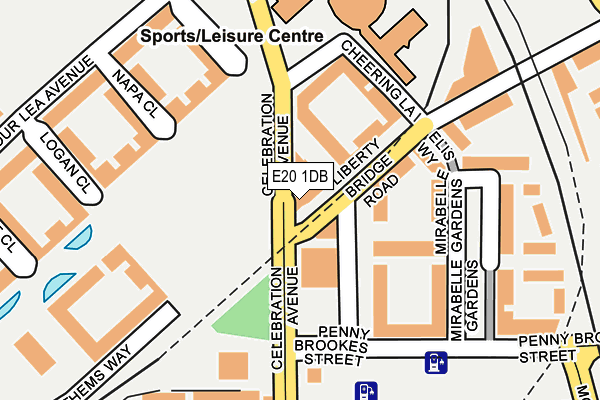
E20 1DB is located in the Stratford Olympic Park electoral ward, within the London borough of Newham and the English Parliamentary constituency of West Ham. The Sub Integrated Care Board (ICB) Location is NHS North East London ICB - A3A8R and the police force is Metropolitan Police. This postcode has been in use since October 2013.


GetTheData
Source: OS OpenMap – Local (Ordnance Survey)
Source: OS VectorMap District (Ordnance Survey)
Licence: Open Government Licence (requires attribution)
| Easting | 538233 |
| Northing | 184999 |
| Latitude | 51.546962 |
| Longitude | -0.007820 |
GetTheData
Source: Open Postcode Geo
Licence: Open Government Licence
| Country | England |
| Postcode District | E20 |
➜ Where is London? | |
GetTheData
Source: Land Registry Price Paid Data
Licence: Open Government Licence
Elevation or altitude of E20 1DB as distance above sea level:
| Metres | Feet | |
|---|---|---|
| Elevation | 10m | 33ft |
Elevation is measured from the approximate centre of the postcode, to the nearest point on an OS contour line from OS Terrain 50, which has contour spacing of ten vertical metres.
➜ How high above sea level am I? Find the elevation of your current position using your device's GPS.
GetTheData
Source: Open Postcode Elevation
Licence: Open Government Licence
| Ward | Stratford Olympic Park |
| Constituency | West Ham |
GetTheData
Source: ONS Postcode Database
Licence: Open Government Licence
| Chobham Academy | Stratford New Town | 81m |
| Sir Ludwig Guttmann Health Centre | Stratford | 108m |
| Chobham Academy | Stratford New Town | 148m |
| Stratford International | Stratford New Town | 158m |
| Stratford International | Stratford New Town | 181m |
| Stratford International Dlr Station | Stratford | 226m |
| Stratford Underground Station | Stratford | 649m |
| Stratford Dlr Station (Station Street) | Stratford | 660m |
| Stratford High Street Dlr Station | Stratford | 1,082m |
| Leyton Underground Station | Leyton | 1,083m |
| Stratford International Station | 0.2km |
| Stratford (London) Station | 0.6km |
| Maryland Station | 1km |
GetTheData
Source: NaPTAN
Licence: Open Government Licence
| Median download speed | 10.4Mbps |
| Average download speed | 8.7Mbps |
| Maximum download speed | 11.12Mbps |
| Median upload speed | 1.0Mbps |
| Average upload speed | 1.0Mbps |
| Maximum upload speed | 1.11Mbps |
GetTheData
Source: Ofcom
Licence: Ofcom Terms of Use (requires attribution)
Estimated total energy consumption in E20 1DB by fuel type, 2015.
| Consumption (kWh) | 39,752 |
|---|---|
| Meter count | 9 |
| Mean (kWh/meter) | 4,417 |
| Median (kWh/meter) | 4,380 |
GetTheData
Source: Postcode level gas estimates: 2015 (experimental)
Source: Postcode level electricity estimates: 2015 (experimental)
Licence: Open Government Licence
GetTheData
Source: ONS Postcode Database
Licence: Open Government Licence


➜ Get more ratings from the Food Standards Agency
GetTheData
Source: Food Standards Agency
Licence: FSA terms & conditions
| Last Collection | |||
|---|---|---|---|
| Location | Mon-Fri | Sat | Distance |
| Chobham Road | 17:30 | 11:30 | 485m |
| Crownfield Road | 17:30 | 11:30 | 519m |
| 178 Major Road E15 | 17:30 | 12:00 | 521m |
GetTheData
Source: Dracos
Licence: Creative Commons Attribution-ShareAlike
The below table lists the International Territorial Level (ITL) codes (formerly Nomenclature of Territorial Units for Statistics (NUTS) codes) and Local Administrative Units (LAU) codes for E20 1DB:
| ITL 1 Code | Name |
|---|---|
| TLI | London |
| ITL 2 Code | Name |
| TLI4 | Inner London - East |
| ITL 3 Code | Name |
| TLI41 | Hackney and Newham |
| LAU 1 Code | Name |
| E09000025 | Newham |
GetTheData
Source: ONS Postcode Directory
Licence: Open Government Licence
The below table lists the Census Output Area (OA), Lower Layer Super Output Area (LSOA), and Middle Layer Super Output Area (MSOA) for E20 1DB:
| Code | Name | |
|---|---|---|
| OA | E00175033 | |
| LSOA | E01033583 | Newham 013G |
| MSOA | E02000726 | Newham 013 |
GetTheData
Source: ONS Postcode Directory
Licence: Open Government Licence
| E20 1BB | Cheering Lane | 189m |
| E20 1ET | Montfichet Road | 381m |
| E15 1BZ | Dorset Place | 426m |
| E15 1JS | Henniker Road | 432m |
| E15 1LY | Chobham Road | 438m |
| E20 1EN | Montfichet Road | 442m |
| E15 1EF | Major Road | 448m |
| E15 1JU | Warren Gardens | 481m |
| E15 1EE | Major Road | 483m |
| E15 1DP | Ashton Road | 486m |
GetTheData
Source: Open Postcode Geo; Land Registry Price Paid Data
Licence: Open Government Licence