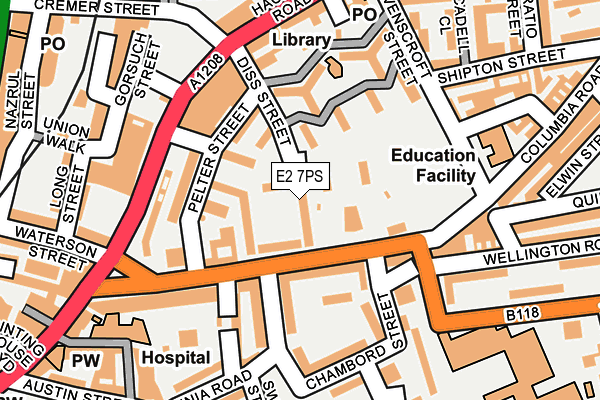
E2 7PS is located in the Weavers electoral ward, within the London borough of Tower Hamlets and the English Parliamentary constituency of Bethnal Green and Bow. The Sub Integrated Care Board (ICB) Location is NHS North East London ICB - A3A8R and the police force is Metropolitan Police. This postcode has been in use since January 1980.


GetTheData
Source: OS OpenMap – Local (Ordnance Survey)
Source: OS VectorMap District (Ordnance Survey)
Licence: Open Government Licence (requires attribution)
| Easting | 533771 |
| Northing | 182863 |
| Latitude | 51.528840 |
| Longitude | -0.072968 |
GetTheData
Source: Open Postcode Geo
Licence: Open Government Licence
| Country | England |
| Postcode District | E2 |
➜ See where E2 is on a map ➜ Where is Bethnal Green? | |
GetTheData
Source: Land Registry Price Paid Data
Licence: Open Government Licence
Elevation or altitude of E2 7PS as distance above sea level:
| Metres | Feet | |
|---|---|---|
| Elevation | 20m | 66ft |
Elevation is measured from the approximate centre of the postcode, to the nearest point on an OS contour line from OS Terrain 50, which has contour spacing of ten vertical metres.
➜ How high above sea level am I? Find the elevation of your current position using your device's GPS.
GetTheData
Source: Open Postcode Elevation
Licence: Open Government Licence
| Ward | Weavers |
| Constituency | Bethnal Green And Bow |
GetTheData
Source: ONS Postcode Database
Licence: Open Government Licence
| Hoxton Station | Hoxton | 147m |
| Hoxton Station | Hoxton | 169m |
| Hackney Road Columbia Road | Shoreditch | 268m |
| Queensbridge Road | Bethnal Green | 280m |
| Shoreditch Church (Hackney Road) | Shoreditch | 305m |
| Old Street Underground Station | Old Street | 1,079m |
| Bethnal Green Underground Station | Bethnal Green | 1,225m |
| Whitechapel Underground Station | Whitechapel | 1,374m |
| Liverpool Street Underground Station | Liverpool Street | 1,459m |
| Moorgate Underground Station | Moorgate | 1,595m |
| Hoxton Station | 0.4km |
| Shoreditch High Street Station | 0.6km |
| Bethnal Green Station | 1.1km |
GetTheData
Source: NaPTAN
Licence: Open Government Licence
| Percentage of properties with Next Generation Access | 100.0% |
| Percentage of properties with Superfast Broadband | 100.0% |
| Percentage of properties with Ultrafast Broadband | 25.0% |
| Percentage of properties with Full Fibre Broadband | 0.0% |
Superfast Broadband is between 30Mbps and 300Mbps
Ultrafast Broadband is > 300Mbps
| Percentage of properties unable to receive 2Mbps | 0.0% |
| Percentage of properties unable to receive 5Mbps | 0.0% |
| Percentage of properties unable to receive 10Mbps | 0.0% |
| Percentage of properties unable to receive 30Mbps | 0.0% |
GetTheData
Source: Ofcom
Licence: Ofcom Terms of Use (requires attribution)
GetTheData
Source: ONS Postcode Database
Licence: Open Government Licence


➜ Get more ratings from the Food Standards Agency
GetTheData
Source: Food Standards Agency
Licence: FSA terms & conditions
| Last Collection | |||
|---|---|---|---|
| Location | Mon-Fri | Sat | Distance |
| Columbia Road | 17:00 | 11:30 | 138m |
| 198 Hackney Road E2 | 18:30 | 12:00 | 225m |
| Ducal Street | 18:30 | 11:30 | 259m |
GetTheData
Source: Dracos
Licence: Creative Commons Attribution-ShareAlike
The below table lists the International Territorial Level (ITL) codes (formerly Nomenclature of Territorial Units for Statistics (NUTS) codes) and Local Administrative Units (LAU) codes for E2 7PS:
| ITL 1 Code | Name |
|---|---|
| TLI | London |
| ITL 2 Code | Name |
| TLI4 | Inner London - East |
| ITL 3 Code | Name |
| TLI42 | Tower Hamlets |
| LAU 1 Code | Name |
| E09000030 | Tower Hamlets |
GetTheData
Source: ONS Postcode Directory
Licence: Open Government Licence
The below table lists the Census Output Area (OA), Lower Layer Super Output Area (LSOA), and Middle Layer Super Output Area (MSOA) for E2 7PS:
| Code | Name | |
|---|---|---|
| OA | E00021729 | |
| LSOA | E01004311 | Tower Hamlets 006A |
| MSOA | E02000869 | Tower Hamlets 006 |
GetTheData
Source: ONS Postcode Directory
Licence: Open Government Licence
| E2 7PN | Baroness Road | 30m |
| E2 7PW | Baroness Road | 39m |
| E2 7PH | Columbia Road | 54m |
| E2 7PJ | Columbia Road | 54m |
| E2 7PQ | Old Market Square | 55m |
| E2 7PL | Baroness Road | 71m |
| E2 7NN | Columbia Road | 75m |
| E2 7PF | Pelter Street | 78m |
| E2 7RA | Vaughan Estate | 95m |
| E2 7NG | Virginia Road | 100m |
GetTheData
Source: Open Postcode Geo; Land Registry Price Paid Data
Licence: Open Government Licence