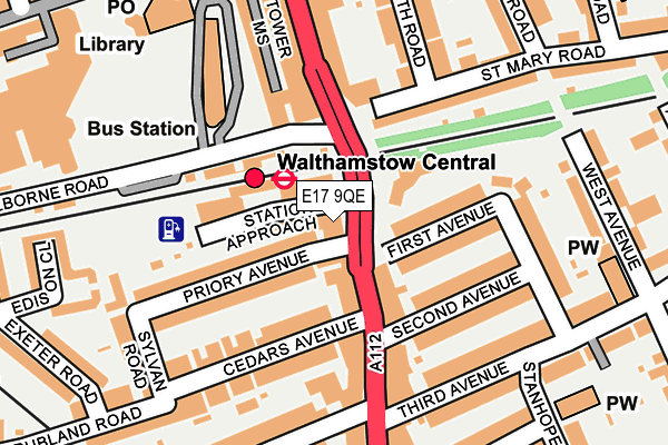
E17 9QE is located in the Markhouse electoral ward, within the London borough of Waltham Forest and the English Parliamentary constituency of Walthamstow. The Sub Integrated Care Board (ICB) Location is NHS North East London ICB - A3A8R and the police force is Metropolitan Police. This postcode has been in use since January 1980.


GetTheData
Source: OS OpenMap – Local (Ordnance Survey)
Source: OS VectorMap District (Ordnance Survey)
Licence: Open Government Licence (requires attribution)
| Easting | 537361 |
| Northing | 188932 |
| Latitude | 51.582515 |
| Longitude | -0.018880 |
GetTheData
Source: Open Postcode Geo
Licence: Open Government Licence
| Country | England |
| Postcode District | E17 |
➜ See where E17 is on a map ➜ Where is Walthamstow? | |
GetTheData
Source: Land Registry Price Paid Data
Licence: Open Government Licence
Elevation or altitude of E17 9QE as distance above sea level:
| Metres | Feet | |
|---|---|---|
| Elevation | 30m | 98ft |
Elevation is measured from the approximate centre of the postcode, to the nearest point on an OS contour line from OS Terrain 50, which has contour spacing of ten vertical metres.
➜ How high above sea level am I? Find the elevation of your current position using your device's GPS.
GetTheData
Source: Open Postcode Elevation
Licence: Open Government Licence
| Ward | Markhouse |
| Constituency | Walthamstow |
GetTheData
Source: ONS Postcode Database
Licence: Open Government Licence
| Walthamstow Central Station (Hoe Street) | Walthamstow | 67m |
| Walthamstow Central Station | Walthamstow | 72m |
| Walthamstow Central Station (Selborne Road) | Walthamstow | 96m |
| Walthamstow Bus Station | Walthamstow | 127m |
| Walthamstow Central Station (Selborne Road) | Walthamstow | 173m |
| Walthamstow Central Underground Station | Walthamstow Central | 86m |
| Walthamstow Central Station | 0.1km |
| Walthamstow Queens Road Station | 0.4km |
| St James Street (London) Station | 1km |
GetTheData
Source: NaPTAN
Licence: Open Government Licence
GetTheData
Source: ONS Postcode Database
Licence: Open Government Licence


➜ Get more ratings from the Food Standards Agency
GetTheData
Source: Food Standards Agency
Licence: FSA terms & conditions
| Last Collection | |||
|---|---|---|---|
| Location | Mon-Fri | Sat | Distance |
| O/S 282-284 Hoe Street | 17:30 | 12:00 | 14m |
| O/S 267 High Street | 18:30 | 12:00 | 265m |
| 267 High Street E17 | 18:30 | 12:00 | 265m |
GetTheData
Source: Dracos
Licence: Creative Commons Attribution-ShareAlike
The below table lists the International Territorial Level (ITL) codes (formerly Nomenclature of Territorial Units for Statistics (NUTS) codes) and Local Administrative Units (LAU) codes for E17 9QE:
| ITL 1 Code | Name |
|---|---|
| TLI | London |
| ITL 2 Code | Name |
| TLI5 | Outer London - East and North East |
| ITL 3 Code | Name |
| TLI53 | Redbridge and Waltham Forest |
| LAU 1 Code | Name |
| E09000031 | Waltham Forest |
GetTheData
Source: ONS Postcode Directory
Licence: Open Government Licence
The below table lists the Census Output Area (OA), Lower Layer Super Output Area (LSOA), and Middle Layer Super Output Area (MSOA) for E17 9QE:
| Code | Name | |
|---|---|---|
| OA | E00022352 | |
| LSOA | E01004443 | Waltham Forest 016E |
| MSOA | E02000910 | Waltham Forest 016 |
GetTheData
Source: ONS Postcode Directory
Licence: Open Government Licence
| E17 9GY | Station Approach | 34m |
| E17 9QD | Hoe Street | 49m |
| E17 9PP | Hoe Street | 87m |
| E17 7QP | Priory Avenue | 105m |
| E17 9QQ | First Avenue | 106m |
| E17 7JP | Selborne Road | 116m |
| E17 7QN | Cedars Avenue | 132m |
| E17 3AX | Hoe Street | 145m |
| E17 3AP | Hoe Street | 148m |
| E17 9QH | Second Avenue | 149m |
GetTheData
Source: Open Postcode Geo; Land Registry Price Paid Data
Licence: Open Government Licence