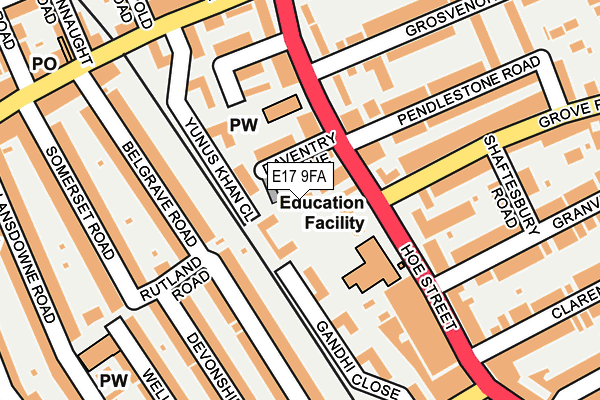
E17 9FA lies on Ledger Mews in London. E17 9FA is located in the Markhouse electoral ward, within the London borough of Waltham Forest and the English Parliamentary constituency of Walthamstow. The Sub Integrated Care Board (ICB) Location is NHS North East London ICB - A3A8R and the police force is Metropolitan Police. This postcode has been in use since September 2015.


GetTheData
Source: OS OpenMap – Local (Ordnance Survey)
Source: OS VectorMap District (Ordnance Survey)
Licence: Open Government Licence (requires attribution)
| Easting | 537425 |
| Northing | 188450 |
| Latitude | 51.578168 |
| Longitude | -0.018145 |
GetTheData
Source: Open Postcode Geo
Licence: Open Government Licence
| Street | Ledger Mews |
| Town/City | London |
| Country | England |
| Postcode District | E17 |
➜ See where E17 is on a map ➜ Where is Walthamstow? | |
GetTheData
Source: Land Registry Price Paid Data
Licence: Open Government Licence
Elevation or altitude of E17 9FA as distance above sea level:
| Metres | Feet | |
|---|---|---|
| Elevation | 20m | 66ft |
Elevation is measured from the approximate centre of the postcode, to the nearest point on an OS contour line from OS Terrain 50, which has contour spacing of ten vertical metres.
➜ How high above sea level am I? Find the elevation of your current position using your device's GPS.
GetTheData
Source: Open Postcode Elevation
Licence: Open Government Licence
| Ward | Markhouse |
| Constituency | Walthamstow |
GetTheData
Source: ONS Postcode Database
Licence: Open Government Licence
| Grove Road Walthamstow (Hoe Street) | Walthamstow Central | 62m |
| Grove Road Walthamstow (Hoe Street) | Walthamstow Central | 140m |
| Grosvenor Park Road (Hoe Street) | Walthamstow Central | 155m |
| Queen's Road Hoe Street (Hoe Street) | Walthamstow | 274m |
| Bakers Avenue | Walthamstow | 319m |
| Walthamstow Central Underground Station | Walthamstow Central | 547m |
| Walthamstow Central Station | 0.5km |
| Walthamstow Queens Road Station | 0.5km |
| St James Street (London) Station | 1.1km |
GetTheData
Source: NaPTAN
Licence: Open Government Licence
| Percentage of properties with Next Generation Access | 100.0% |
| Percentage of properties with Superfast Broadband | 100.0% |
| Percentage of properties with Ultrafast Broadband | 0.0% |
| Percentage of properties with Full Fibre Broadband | 0.0% |
Superfast Broadband is between 30Mbps and 300Mbps
Ultrafast Broadband is > 300Mbps
| Median download speed | 45.7Mbps |
| Average download speed | 47.1Mbps |
| Maximum download speed | 80.00Mbps |
| Median upload speed | 12.8Mbps |
| Average upload speed | 10.6Mbps |
| Maximum upload speed | 20.00Mbps |
| Percentage of properties unable to receive 2Mbps | 0.0% |
| Percentage of properties unable to receive 5Mbps | 0.0% |
| Percentage of properties unable to receive 10Mbps | 0.0% |
| Percentage of properties unable to receive 30Mbps | 0.0% |
GetTheData
Source: Ofcom
Licence: Ofcom Terms of Use (requires attribution)
Estimated total energy consumption in E17 9FA by fuel type, 2015.
| Consumption (kWh) | 74,834 |
|---|---|
| Meter count | 7 |
| Mean (kWh/meter) | 10,691 |
| Median (kWh/meter) | 10,659 |
| Consumption (kWh) | 13,927 |
|---|---|
| Meter count | 8 |
| Mean (kWh/meter) | 1,741 |
| Median (kWh/meter) | 1,835 |
GetTheData
Source: Postcode level gas estimates: 2015 (experimental)
Source: Postcode level electricity estimates: 2015 (experimental)
Licence: Open Government Licence
GetTheData
Source: ONS Postcode Database
Licence: Open Government Licence


➜ Get more ratings from the Food Standards Agency
GetTheData
Source: Food Standards Agency
Licence: FSA terms & conditions
| Last Collection | |||
|---|---|---|---|
| Location | Mon-Fri | Sat | Distance |
| Granville Road | 17:30 | 11:30 | 166m |
| Orford Road | 17:30 | 11:30 | 202m |
| Queens Road | 17:30 | 11:30 | 297m |
GetTheData
Source: Dracos
Licence: Creative Commons Attribution-ShareAlike
The below table lists the International Territorial Level (ITL) codes (formerly Nomenclature of Territorial Units for Statistics (NUTS) codes) and Local Administrative Units (LAU) codes for E17 9FA:
| ITL 1 Code | Name |
|---|---|
| TLI | London |
| ITL 2 Code | Name |
| TLI5 | Outer London - East and North East |
| ITL 3 Code | Name |
| TLI53 | Redbridge and Waltham Forest |
| LAU 1 Code | Name |
| E09000031 | Waltham Forest |
GetTheData
Source: ONS Postcode Directory
Licence: Open Government Licence
The below table lists the Census Output Area (OA), Lower Layer Super Output Area (LSOA), and Middle Layer Super Output Area (MSOA) for E17 9FA:
| Code | Name | |
|---|---|---|
| OA | E00022166 | |
| LSOA | E01004406 | Waltham Forest 016A |
| MSOA | E02000910 | Waltham Forest 016 |
GetTheData
Source: ONS Postcode Directory
Licence: Open Government Licence
| E17 9AQ | Daventry Avenue | 30m |
| E17 8XQ | Yunus Khan Close | 53m |
| E17 8XG | Yunus Khan Close | 66m |
| E17 8LN | Gandhi Close | 86m |
| E17 9AA | Hoe Street | 93m |
| E17 9BG | Hoe Street | 97m |
| E17 8XF | Yunus Khan Close | 99m |
| E17 9AF | Abbey Mews | 119m |
| E17 8LW | Gandhi Close | 127m |
| E17 9BD | Hoe Street | 143m |
GetTheData
Source: Open Postcode Geo; Land Registry Price Paid Data
Licence: Open Government Licence