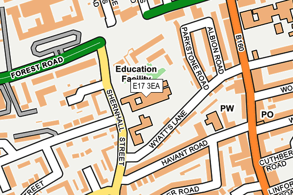
E17 3EA is located in the Wood Street electoral ward, within the London borough of Waltham Forest and the English Parliamentary constituency of Walthamstow. The Sub Integrated Care Board (ICB) Location is NHS North East London ICB - A3A8R and the police force is Metropolitan Police. This postcode has been in use since January 1980.


GetTheData
Source: OS OpenMap – Local (Ordnance Survey)
Source: OS VectorMap District (Ordnance Survey)
Licence: Open Government Licence (requires attribution)
| Easting | 538136 |
| Northing | 189749 |
| Latitude | 51.589667 |
| Longitude | -0.007380 |
GetTheData
Source: Open Postcode Geo
Licence: Open Government Licence
| Country | England |
| Postcode District | E17 |
➜ See where E17 is on a map ➜ Where is Walthamstow? | |
GetTheData
Source: Land Registry Price Paid Data
Licence: Open Government Licence
Elevation or altitude of E17 3EA as distance above sea level:
| Metres | Feet | |
|---|---|---|
| Elevation | 30m | 98ft |
Elevation is measured from the approximate centre of the postcode, to the nearest point on an OS contour line from OS Terrain 50, which has contour spacing of ten vertical metres.
➜ How high above sea level am I? Find the elevation of your current position using your device's GPS.
GetTheData
Source: Open Postcode Elevation
Licence: Open Government Licence
| Ward | Wood Street |
| Constituency | Walthamstow |
GetTheData
Source: ONS Postcode Database
Licence: Open Government Licence
| The Drive Shernhall Street (Shernhall Street) | Upper Walthamstow | 69m |
| The Drive Shernhall Street (Shernhall Street) | Upper Walthamstow | 81m |
| Thorpe Coombe Hospital (Forest Road) | Upper Walthamstow | 145m |
| St John's Road (Forest Road) | Upper Walthamstow | 201m |
| Woodlands Road Wood Street | Upper Walthamstow | 218m |
| Walthamstow Central Underground Station | Walthamstow Central | 1,143m |
| Wood Street Station | 0.5km |
| Walthamstow Central Station | 1.1km |
| Walthamstow Queens Road Station | 1.5km |
GetTheData
Source: NaPTAN
Licence: Open Government Licence
GetTheData
Source: ONS Postcode Database
Licence: Open Government Licence


➜ Get more ratings from the Food Standards Agency
GetTheData
Source: Food Standards Agency
Licence: FSA terms & conditions
| Last Collection | |||
|---|---|---|---|
| Location | Mon-Fri | Sat | Distance |
| Havant Road | 17:30 | 12:00 | 181m |
| Clifford Road | 17:30 | 11:30 | 205m |
| Waverley Road | 17:30 | 11:30 | 227m |
GetTheData
Source: Dracos
Licence: Creative Commons Attribution-ShareAlike
The below table lists the International Territorial Level (ITL) codes (formerly Nomenclature of Territorial Units for Statistics (NUTS) codes) and Local Administrative Units (LAU) codes for E17 3EA:
| ITL 1 Code | Name |
|---|---|
| TLI | London |
| ITL 2 Code | Name |
| TLI5 | Outer London - East and North East |
| ITL 3 Code | Name |
| TLI53 | Redbridge and Waltham Forest |
| LAU 1 Code | Name |
| E09000031 | Waltham Forest |
GetTheData
Source: ONS Postcode Directory
Licence: Open Government Licence
The below table lists the Census Output Area (OA), Lower Layer Super Output Area (LSOA), and Middle Layer Super Output Area (MSOA) for E17 3EA:
| Code | Name | |
|---|---|---|
| OA | E00022463 | |
| LSOA | E01004470 | Waltham Forest 013E |
| MSOA | E02000907 | Waltham Forest 013 |
GetTheData
Source: ONS Postcode Directory
Licence: Open Government Licence
| E17 3AF | Hatton Terrace | 93m |
| E17 3DQ | The Drive | 108m |
| E17 3HN | Shernhall Street | 114m |
| E17 3JB | Parkstone Road | 115m |
| E17 3JF | Havant Road | 123m |
| E17 3DU | The Drive | 124m |
| E17 3JD | Wyatts Lane | 131m |
| E17 3DG | The Drive | 139m |
| E17 3JA | Parkstone Road | 139m |
| E17 3ET | Shernhall Street | 144m |
GetTheData
Source: Open Postcode Geo; Land Registry Price Paid Data
Licence: Open Government Licence