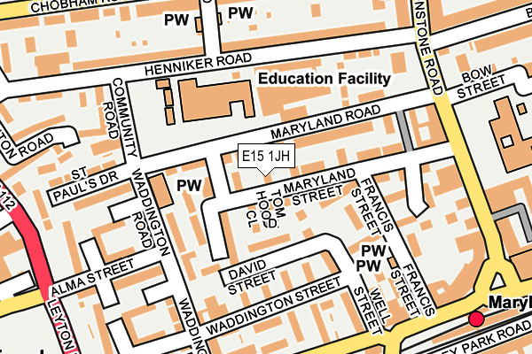
E15 1JH is located in the Maryland electoral ward, within the London borough of Newham and the English Parliamentary constituency of West Ham. The Sub Integrated Care Board (ICB) Location is NHS North East London ICB - A3A8R and the police force is Metropolitan Police. This postcode has been in use since January 1991.


GetTheData
Source: OS OpenMap – Local (Ordnance Survey)
Source: OS VectorMap District (Ordnance Survey)
Licence: Open Government Licence (requires attribution)
| Easting | 538954 |
| Northing | 185090 |
| Latitude | 51.547603 |
| Longitude | 0.002607 |
GetTheData
Source: Open Postcode Geo
Licence: Open Government Licence
| Country | England |
| Postcode District | E15 |
➜ See where E15 is on a map ➜ Where is London? | |
GetTheData
Source: Land Registry Price Paid Data
Licence: Open Government Licence
Elevation or altitude of E15 1JH as distance above sea level:
| Metres | Feet | |
|---|---|---|
| Elevation | 10m | 33ft |
Elevation is measured from the approximate centre of the postcode, to the nearest point on an OS contour line from OS Terrain 50, which has contour spacing of ten vertical metres.
➜ How high above sea level am I? Find the elevation of your current position using your device's GPS.
GetTheData
Source: Open Postcode Elevation
Licence: Open Government Licence
| Ward | Maryland |
| Constituency | West Ham |
GetTheData
Source: ONS Postcode Database
Licence: Open Government Licence
| Maryland (Leytonstone Road) | Stratford | 241m |
| Chobham Road (Leytonstone Road) | Stratford New Town | 255m |
| Maryland Station Manbey Grove (The Grove) | Stratford | 260m |
| Maryland (Leytonstone Road) | Stratford | 266m |
| Windmill Lane (Leyton Road) | Stratford | 278m |
| Stratford Dlr Station (Station Street) | Stratford | 767m |
| Stratford Underground Station | Stratford | 769m |
| Stratford International Dlr Station | Stratford | 886m |
| Stratford High Street Dlr Station | Stratford | 1,077m |
| Leyton Underground Station | Leyton | 1,147m |
| Maryland Station | 0.3km |
| Stratford (London) Station | 0.8km |
| Stratford International Station | 0.8km |
GetTheData
Source: NaPTAN
Licence: Open Government Licence
| Percentage of properties with Next Generation Access | 100.0% |
| Percentage of properties with Superfast Broadband | 100.0% |
| Percentage of properties with Ultrafast Broadband | 83.3% |
| Percentage of properties with Full Fibre Broadband | 0.0% |
Superfast Broadband is between 30Mbps and 300Mbps
Ultrafast Broadband is > 300Mbps
| Percentage of properties unable to receive 2Mbps | 0.0% |
| Percentage of properties unable to receive 5Mbps | 0.0% |
| Percentage of properties unable to receive 10Mbps | 0.0% |
| Percentage of properties unable to receive 30Mbps | 0.0% |
GetTheData
Source: Ofcom
Licence: Ofcom Terms of Use (requires attribution)
Estimated total energy consumption in E15 1JH by fuel type, 2015.
| Consumption (kWh) | 46,114 |
|---|---|
| Meter count | 6 |
| Mean (kWh/meter) | 7,686 |
| Median (kWh/meter) | 8,220 |
| Consumption (kWh) | 16,850 |
|---|---|
| Meter count | 6 |
| Mean (kWh/meter) | 2,808 |
| Median (kWh/meter) | 2,913 |
GetTheData
Source: Postcode level gas estimates: 2015 (experimental)
Source: Postcode level electricity estimates: 2015 (experimental)
Licence: Open Government Licence
GetTheData
Source: ONS Postcode Database
Licence: Open Government Licence


➜ Get more ratings from the Food Standards Agency
GetTheData
Source: Food Standards Agency
Licence: FSA terms & conditions
| Last Collection | |||
|---|---|---|---|
| Location | Mon-Fri | Sat | Distance |
| 85 Leytonstone Road | 17:30 | 11:30 | 223m |
| Maryland Street | 17:30 | 11:30 | 223m |
| Windmill Lane | 17:30 | 11:30 | 280m |
GetTheData
Source: Dracos
Licence: Creative Commons Attribution-ShareAlike
The below table lists the International Territorial Level (ITL) codes (formerly Nomenclature of Territorial Units for Statistics (NUTS) codes) and Local Administrative Units (LAU) codes for E15 1JH:
| ITL 1 Code | Name |
|---|---|
| TLI | London |
| ITL 2 Code | Name |
| TLI4 | Inner London - East |
| ITL 3 Code | Name |
| TLI41 | Hackney and Newham |
| LAU 1 Code | Name |
| E09000025 | Newham |
GetTheData
Source: ONS Postcode Directory
Licence: Open Government Licence
The below table lists the Census Output Area (OA), Lower Layer Super Output Area (LSOA), and Middle Layer Super Output Area (MSOA) for E15 1JH:
| Code | Name | |
|---|---|---|
| OA | E00018222 | |
| LSOA | E01003616 | Newham 012A |
| MSOA | E02000725 | Newham 012 |
GetTheData
Source: ONS Postcode Directory
Licence: Open Government Licence
| E15 1JQ | Falmouth Street | 52m |
| E15 1JE | Tom Hood Close | 60m |
| E15 1JJ | Maryland Road | 71m |
| E15 1PR | Maldon Close | 79m |
| E15 1JL | Maryland Road | 95m |
| E15 1PU | Store Street | 99m |
| E15 1JD | Maryland Street | 107m |
| E15 1PP | David Street | 109m |
| E15 1JW | Maryland Road | 114m |
| E15 1JY | Henniker Road | 119m |
GetTheData
Source: Open Postcode Geo; Land Registry Price Paid Data
Licence: Open Government Licence