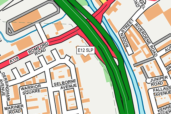
E12 5LP lies on Romford Road in Manor Park, London. E12 5LP is located in the Little Ilford electoral ward, within the London borough of Newham and the English Parliamentary constituency of East Ham. The Sub Integrated Care Board (ICB) Location is NHS North East London ICB - A3A8R and the police force is Metropolitan Police. This postcode has been in use since January 1980.


GetTheData
Source: OS OpenMap – Local (Ordnance Survey)
Source: OS VectorMap District (Ordnance Survey)
Licence: Open Government Licence (requires attribution)
| Easting | 543277 |
| Northing | 186073 |
| Latitude | 51.555353 |
| Longitude | 0.065282 |
GetTheData
Source: Open Postcode Geo
Licence: Open Government Licence
| Street | Romford Road |
| Locality | Manor Park |
| Town/City | London |
| Country | England |
| Postcode District | E12 |
➜ See where E12 is on a map ➜ Where is London? | |
GetTheData
Source: Land Registry Price Paid Data
Licence: Open Government Licence
Elevation or altitude of E12 5LP as distance above sea level:
| Metres | Feet | |
|---|---|---|
| Elevation | 10m | 33ft |
Elevation is measured from the approximate centre of the postcode, to the nearest point on an OS contour line from OS Terrain 50, which has contour spacing of ten vertical metres.
➜ How high above sea level am I? Find the elevation of your current position using your device's GPS.
GetTheData
Source: Open Postcode Elevation
Licence: Open Government Licence
| Ward | Little Ilford |
| Constituency | East Ham |
GetTheData
Source: ONS Postcode Database
Licence: Open Government Licence
| North Circular Rd Romford Rd (Romford Road) | Little Ilford | 160m |
| Dersingham Avenue (Romford Road) | Little Ilford | 225m |
| Roden Street | Ilford | 267m |
| Chapel Road | Ilford | 286m |
| Little Ilford Lane | Little Ilford | 331m |
| Ilford Station | 0.5km |
| Manor Park Station | 1.4km |
| Woodgrange Park Station | 1.6km |
GetTheData
Source: NaPTAN
Licence: Open Government Licence
GetTheData
Source: ONS Postcode Database
Licence: Open Government Licence


➜ Get more ratings from the Food Standards Agency
GetTheData
Source: Food Standards Agency
Licence: FSA terms & conditions
| Last Collection | |||
|---|---|---|---|
| Location | Mon-Fri | Sat | Distance |
| Riverdene Road | 17:45 | 12:00 | 276m |
| 16 Walter Hurford Parade E12 | 17:00 | 12:00 | 277m |
| Cardomom Court | 17:30 | 11:30 | 331m |
GetTheData
Source: Dracos
Licence: Creative Commons Attribution-ShareAlike
The below table lists the International Territorial Level (ITL) codes (formerly Nomenclature of Territorial Units for Statistics (NUTS) codes) and Local Administrative Units (LAU) codes for E12 5LP:
| ITL 1 Code | Name |
|---|---|
| TLI | London |
| ITL 2 Code | Name |
| TLI4 | Inner London - East |
| ITL 3 Code | Name |
| TLI41 | Hackney and Newham |
| LAU 1 Code | Name |
| E09000025 | Newham |
GetTheData
Source: ONS Postcode Directory
Licence: Open Government Licence
The below table lists the Census Output Area (OA), Lower Layer Super Output Area (LSOA), and Middle Layer Super Output Area (MSOA) for E12 5LP:
| Code | Name | |
|---|---|---|
| OA | E00018046 | |
| LSOA | E01003577 | Newham 005C |
| MSOA | E02000718 | Newham 005 |
GetTheData
Source: ONS Postcode Directory
Licence: Open Government Licence
| E12 5NT | Grantham Road | 84m |
| E12 5LX | Grantham Road | 98m |
| E12 5NP | Selborne Avenue | 110m |
| E12 5NS | Grantham Road | 127m |
| E12 5NE | Grantham Road | 133m |
| E12 5RA | Walton Road | 134m |
| E12 5NW | Selborne Avenue | 136m |
| IG1 2FP | Roden Street | 142m |
| IG1 2AQ | Roden Street | 170m |
| E12 5RW | Grantham Road | 174m |
GetTheData
Source: Open Postcode Geo; Land Registry Price Paid Data
Licence: Open Government Licence