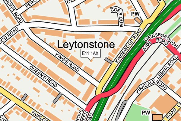
E11 1AX lies on Kings Passage in London. E11 1AX is located in the Leytonstone electoral ward, within the London borough of Waltham Forest and the English Parliamentary constituency of Leyton and Wanstead. The Sub Integrated Care Board (ICB) Location is NHS North East London ICB - A3A8R and the police force is Metropolitan Police. This postcode has been in use since January 1980.


GetTheData
Source: OS OpenMap – Local (Ordnance Survey)
Source: OS VectorMap District (Ordnance Survey)
Licence: Open Government Licence (requires attribution)
| Easting | 539245 |
| Northing | 187646 |
| Latitude | 51.570497 |
| Longitude | 0.007785 |
GetTheData
Source: Open Postcode Geo
Licence: Open Government Licence
| Street | Kings Passage |
| Town/City | London |
| Country | England |
| Postcode District | E11 |
➜ See where E11 is on a map ➜ Where is London? | |
GetTheData
Source: Land Registry Price Paid Data
Licence: Open Government Licence
Elevation or altitude of E11 1AX as distance above sea level:
| Metres | Feet | |
|---|---|---|
| Elevation | 20m | 66ft |
Elevation is measured from the approximate centre of the postcode, to the nearest point on an OS contour line from OS Terrain 50, which has contour spacing of ten vertical metres.
➜ How high above sea level am I? Find the elevation of your current position using your device's GPS.
GetTheData
Source: Open Postcode Elevation
Licence: Open Government Licence
| Ward | Leytonstone |
| Constituency | Leyton And Wanstead |
GetTheData
Source: ONS Postcode Database
Licence: Open Government Licence
1, KINGS PASSAGE, LONDON, E11 1AX 2000 12 JUN £91,500 |
1, KINGS PASSAGE, LONDON, E11 1AX 1996 29 MAR £91,500 |
GetTheData
Source: HM Land Registry Price Paid Data
Licence: Contains HM Land Registry data © Crown copyright and database right 2025. This data is licensed under the Open Government Licence v3.0.
| Gainsborough Road (E11) | Leytonstone | 140m |
| Gainsborough Road (E11) | Leytonstone | 157m |
| Leytonstone Station (Kirkdale Road) | Leytonstone | 179m |
| Leytonstone Station (Kirkdale Road) | Leytonstone | 189m |
| Leytonstone Station (Kirkdale Road) | Leytonstone | 198m |
| Leytonstone Underground Station | Leytonstone | 244m |
| Snaresbrook Underground Station | Snaresbrook | 1,476m |
| Wanstead Underground Station | Wanstead | 1,542m |
| Leytonstone High Road Station | 0.8km |
| Leyton Midland Road Station | 1.1km |
| Wood Street Station | 1.9km |
GetTheData
Source: NaPTAN
Licence: Open Government Licence
| Percentage of properties with Next Generation Access | 100.0% |
| Percentage of properties with Superfast Broadband | 100.0% |
| Percentage of properties with Ultrafast Broadband | 0.0% |
| Percentage of properties with Full Fibre Broadband | 0.0% |
Superfast Broadband is between 30Mbps and 300Mbps
Ultrafast Broadband is > 300Mbps
| Percentage of properties unable to receive 2Mbps | 0.0% |
| Percentage of properties unable to receive 5Mbps | 0.0% |
| Percentage of properties unable to receive 10Mbps | 0.0% |
| Percentage of properties unable to receive 30Mbps | 0.0% |
GetTheData
Source: Ofcom
Licence: Ofcom Terms of Use (requires attribution)
GetTheData
Source: ONS Postcode Database
Licence: Open Government Licence


➜ Get more ratings from the Food Standards Agency
GetTheData
Source: Food Standards Agency
Licence: FSA terms & conditions
| Last Collection | |||
|---|---|---|---|
| Location | Mon-Fri | Sat | Distance |
| Kings Road | 17:30 | 11:30 | 90m |
| Fillebrook Road | 17:30 | 11:30 | 224m |
| Leytonstone Plaza | 17:30 | 11:30 | 230m |
GetTheData
Source: Dracos
Licence: Creative Commons Attribution-ShareAlike
The below table lists the International Territorial Level (ITL) codes (formerly Nomenclature of Territorial Units for Statistics (NUTS) codes) and Local Administrative Units (LAU) codes for E11 1AX:
| ITL 1 Code | Name |
|---|---|
| TLI | London |
| ITL 2 Code | Name |
| TLI5 | Outer London - East and North East |
| ITL 3 Code | Name |
| TLI53 | Redbridge and Waltham Forest |
| LAU 1 Code | Name |
| E09000031 | Waltham Forest |
GetTheData
Source: ONS Postcode Directory
Licence: Open Government Licence
The below table lists the Census Output Area (OA), Lower Layer Super Output Area (LSOA), and Middle Layer Super Output Area (MSOA) for E11 1AX:
| Code | Name | |
|---|---|---|
| OA | E00022339 | |
| LSOA | E01004442 | Waltham Forest 021E |
| MSOA | E02000915 | Waltham Forest 021 |
GetTheData
Source: ONS Postcode Directory
Licence: Open Government Licence
| E11 1SG | Kingswood Road | 34m |
| E11 1SF | Kingswood Road | 62m |
| E11 1AT | Kings Road | 70m |
| E11 1AQ | Wallwood Road | 86m |
| E11 1SE | Kingswood Road | 102m |
| E11 1AU | Kings Road | 113m |
| E11 1AN | Wallwood Road | 139m |
| E11 1BB | Queens Road | 153m |
| E11 1AP | Wallwood Road | 158m |
| E11 1SQ | Kingswood Road | 164m |
GetTheData
Source: Open Postcode Geo; Land Registry Price Paid Data
Licence: Open Government Licence