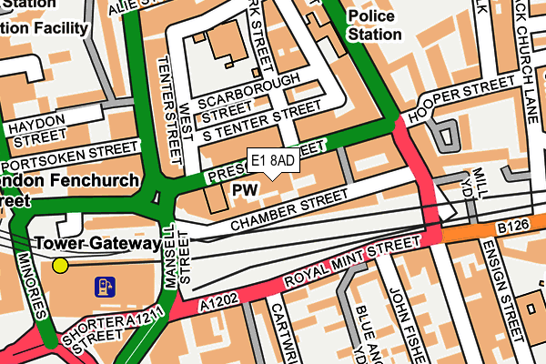
E1 8AD is located in the Whitechapel electoral ward, within the London borough of Tower Hamlets and the English Parliamentary constituency of Bethnal Green and Bow. The Sub Integrated Care Board (ICB) Location is NHS North East London ICB - A3A8R and the police force is Metropolitan Police. This postcode has been in use since March 1988.


GetTheData
Source: OS OpenMap – Local (Ordnance Survey)
Source: OS VectorMap District (Ordnance Survey)
Licence: Open Government Licence (requires attribution)
| Easting | 533953 |
| Northing | 180926 |
| Latitude | 51.511390 |
| Longitude | -0.071082 |
GetTheData
Source: Open Postcode Geo
Licence: Open Government Licence
| Country | England |
| Postcode District | E1 |
➜ See where E1 is on a map ➜ Where is London? | |
GetTheData
Source: Land Registry Price Paid Data
Licence: Open Government Licence
Elevation or altitude of E1 8AD as distance above sea level:
| Metres | Feet | |
|---|---|---|
| Elevation | 10m | 33ft |
Elevation is measured from the approximate centre of the postcode, to the nearest point on an OS contour line from OS Terrain 50, which has contour spacing of ten vertical metres.
➜ How high above sea level am I? Find the elevation of your current position using your device's GPS.
GetTheData
Source: Open Postcode Elevation
Licence: Open Government Licence
| Ward | Whitechapel |
| Constituency | Bethnal Green And Bow |
GetTheData
Source: ONS Postcode Database
Licence: Open Government Licence
| Mansell Street | Aldgate | 226m |
| Tower Hill Tower Gateway Station (Mansell Street) | Tower Gateway | 244m |
| Mansell Street | Aldgate | 270m |
| Tower Gateway (Minories) | Tower Gateway | 294m |
| Tower Gateway (Minories) | Tower Gateway | 304m |
| Tower Gateway Dlr Station (Minories) | Tower Gateway | 273m |
| Tower Hill Underground Station | Tower Hill | 411m |
| Aldgate East Underground Station | Aldgate East | 415m |
| Aldgate Underground Station | Aldgate | 451m |
| Shadwell Dlr Station (Martha Street) | Shadwell | 1,003m |
| London Fenchurch Street Station | 0.5km |
| Shadwell Station | 1km |
| London Liverpool Street Station | 1km |
GetTheData
Source: NaPTAN
Licence: Open Government Licence
GetTheData
Source: ONS Postcode Database
Licence: Open Government Licence


➜ Get more ratings from the Food Standards Agency
GetTheData
Source: Food Standards Agency
Licence: FSA terms & conditions
| Last Collection | |||
|---|---|---|---|
| Location | Mon-Fri | Sat | Distance |
| Mansell Street | 160m | ||
| 141 Leman Street | 18:30 | 11:30 | 177m |
| O/S 141 Leman Street | 18:30 | 11:30 | 177m |
GetTheData
Source: Dracos
Licence: Creative Commons Attribution-ShareAlike
The below table lists the International Territorial Level (ITL) codes (formerly Nomenclature of Territorial Units for Statistics (NUTS) codes) and Local Administrative Units (LAU) codes for E1 8AD:
| ITL 1 Code | Name |
|---|---|
| TLI | London |
| ITL 2 Code | Name |
| TLI4 | Inner London - East |
| ITL 3 Code | Name |
| TLI42 | Tower Hamlets |
| LAU 1 Code | Name |
| E09000030 | Tower Hamlets |
GetTheData
Source: ONS Postcode Directory
Licence: Open Government Licence
The below table lists the Census Output Area (OA), Lower Layer Super Output Area (LSOA), and Middle Layer Super Output Area (MSOA) for E1 8AD:
| Code | Name | |
|---|---|---|
| OA | E00167101 | |
| LSOA | E01032767 | Tower Hamlets 021F |
| MSOA | E02000884 | Tower Hamlets 021 |
GetTheData
Source: ONS Postcode Directory
Licence: Open Government Licence
| E1 8BL | Chamber Street | 22m |
| E1 8BB | Prescot Street | 31m |
| E1 8AP | Mansell Street | 117m |
| E1 8LG | Royal Mint Street | 118m |
| E1 8LS | Royal Mint Place | 119m |
| E1 8DR | Scarborough Street | 119m |
| E1 8AY | Prescot Street | 133m |
| E1 8RJ | Prescot Street | 133m |
| E1 8RL | Prescot Street | 133m |
| E1 8JX | John Fisher Street | 137m |
GetTheData
Source: Open Postcode Geo; Land Registry Price Paid Data
Licence: Open Government Licence