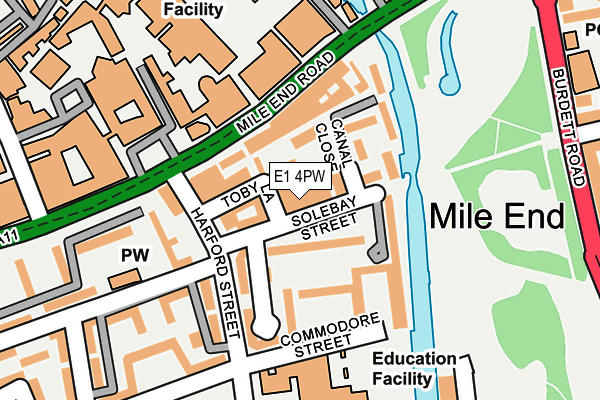
E1 4PW lies on Solebay Street in Mile End, London. E1 4PW is located in the St Dunstan's electoral ward, within the London borough of Tower Hamlets and the English Parliamentary constituency of Bethnal Green and Bow. The Sub Integrated Care Board (ICB) Location is NHS North East London ICB - A3A8R and the police force is Metropolitan Police. This postcode has been in use since January 1980.


GetTheData
Source: OS OpenMap – Local (Ordnance Survey)
Source: OS VectorMap District (Ordnance Survey)
Licence: Open Government Licence (requires attribution)
| Easting | 536204 |
| Northing | 182240 |
| Latitude | 51.522661 |
| Longitude | -0.038130 |
GetTheData
Source: Open Postcode Geo
Licence: Open Government Licence
| Street | Solebay Street |
| Locality | Mile End |
| Town/City | London |
| Country | England |
| Postcode District | E1 |
➜ See where E1 is on a map ➜ Where is London? | |
GetTheData
Source: Land Registry Price Paid Data
Licence: Open Government Licence
Elevation or altitude of E1 4PW as distance above sea level:
| Metres | Feet | |
|---|---|---|
| Elevation | 20m | 66ft |
Elevation is measured from the approximate centre of the postcode, to the nearest point on an OS contour line from OS Terrain 50, which has contour spacing of ten vertical metres.
➜ How high above sea level am I? Find the elevation of your current position using your device's GPS.
GetTheData
Source: Open Postcode Elevation
Licence: Open Government Licence
| Ward | St Dunstan's |
| Constituency | Bethnal Green And Bow |
GetTheData
Source: ONS Postcode Database
Licence: Open Government Licence
| Queen Mary University Of London (Mile End Road) | Mile End | 92m |
| Ernest Street (Harford Street) | Mile End | 103m |
| Ernest Street (Harford Stret) | Mile End | 130m |
| Queen Mary University Of London (Mile End Road) | Mile End | 182m |
| Regents Canal | Mile End | 202m |
| Mile End Underground Station | Mile End | 416m |
| Stepney Green Underground Station | Stepney Green | 592m |
| Bow Road Underground Station | Bow | 1,022m |
| Limehouse Dlr Station (Commercial Road) | Limehouse | 1,148m |
| Bethnal Green Underground Station | Bethnal Green | 1,306m |
| Limehouse Station | 1.1km |
| Bethnal Green Station | 1.5km |
| Whitechapel Station | 1.5km |
GetTheData
Source: NaPTAN
Licence: Open Government Licence
GetTheData
Source: ONS Postcode Database
Licence: Open Government Licence


➜ Get more ratings from the Food Standards Agency
GetTheData
Source: Food Standards Agency
Licence: FSA terms & conditions
| Last Collection | |||
|---|---|---|---|
| Location | Mon-Fri | Sat | Distance |
| Harford Street | 18:30 | 11:30 | 163m |
| Harfoed Street | 18:30 | 11:30 | 166m |
| 1b Burdett Road E3 | 18:30 | 12:00 | 330m |
GetTheData
Source: Dracos
Licence: Creative Commons Attribution-ShareAlike
The below table lists the International Territorial Level (ITL) codes (formerly Nomenclature of Territorial Units for Statistics (NUTS) codes) and Local Administrative Units (LAU) codes for E1 4PW:
| ITL 1 Code | Name |
|---|---|
| TLI | London |
| ITL 2 Code | Name |
| TLI4 | Inner London - East |
| ITL 3 Code | Name |
| TLI42 | Tower Hamlets |
| LAU 1 Code | Name |
| E09000030 | Tower Hamlets |
GetTheData
Source: ONS Postcode Directory
Licence: Open Government Licence
The below table lists the Census Output Area (OA), Lower Layer Super Output Area (LSOA), and Middle Layer Super Output Area (MSOA) for E1 4PW:
| Code | Name | |
|---|---|---|
| OA | E00167251 | |
| LSOA | E01004261 | Tower Hamlets 010A |
| MSOA | E02000873 | Tower Hamlets 010 |
GetTheData
Source: ONS Postcode Directory
Licence: Open Government Licence
| E1 4PP | Solebay Street | 58m |
| E1 4DP | Toby Lane | 65m |
| E1 4PG | Union Drive | 73m |
| E1 4PE | Mile End Road | 79m |
| E1 4PQ | Harford Street | 87m |
| E1 4QL | Sandalwood Close | 92m |
| E1 4QN | Emmott Close | 99m |
| E1 4PH | Harford Street | 101m |
| E1 4QW | Emmott Close | 102m |
| E1 4PJ | Grand Walk | 119m |
GetTheData
Source: Open Postcode Geo; Land Registry Price Paid Data
Licence: Open Government Licence