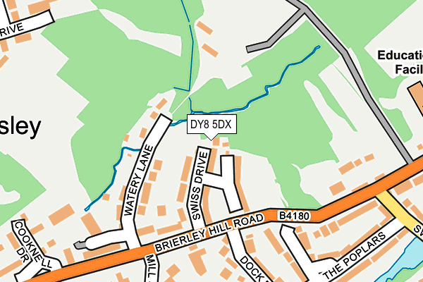
DY8 5DX is located in the Wordsley electoral ward, within the metropolitan district of Dudley and the English Parliamentary constituency of Dudley South. The Sub Integrated Care Board (ICB) Location is NHS Black Country ICB - D2P2L and the police force is West Midlands. This postcode has been in use since January 1980.


GetTheData
Source: OS OpenMap – Local (Ordnance Survey)
Source: OS VectorMap District (Ordnance Survey)
Licence: Open Government Licence (requires attribution)
| Easting | 389579 |
| Northing | 286899 |
| Latitude | 52.479929 |
| Longitude | -2.154862 |
GetTheData
Source: Open Postcode Geo
Licence: Open Government Licence
| Country | England |
| Postcode District | DY8 |
➜ See where DY8 is on a map ➜ Where is Kingswinford? | |
GetTheData
Source: Land Registry Price Paid Data
Licence: Open Government Licence
Elevation or altitude of DY8 5DX as distance above sea level:
| Metres | Feet | |
|---|---|---|
| Elevation | 80m | 262ft |
Elevation is measured from the approximate centre of the postcode, to the nearest point on an OS contour line from OS Terrain 50, which has contour spacing of ten vertical metres.
➜ How high above sea level am I? Find the elevation of your current position using your device's GPS.
GetTheData
Source: Open Postcode Elevation
Licence: Open Government Licence
| Ward | Wordsley |
| Constituency | Dudley South |
GetTheData
Source: ONS Postcode Database
Licence: Open Government Licence
| Brierley Hill Rd (Swan Lane) | Buckpool | 279m |
| High St (Brierley Hill Rd) | Buckpool | 300m |
| High St (Brierley Hill Rd) | Buckpool | 330m |
| Westcott Close (Rangeways Rd) | Buckpool | 346m |
| Brierley Hill Rd (Swan Lane) | Buckpool | 356m |
| Stourbridge Town Station | 2.8km |
| Lye (West Midlands) Station | 3.5km |
| Stourbridge Junction Station | 3.9km |
GetTheData
Source: NaPTAN
Licence: Open Government Licence
| Percentage of properties with Next Generation Access | 100.0% |
| Percentage of properties with Superfast Broadband | 100.0% |
| Percentage of properties with Ultrafast Broadband | 0.0% |
| Percentage of properties with Full Fibre Broadband | 0.0% |
Superfast Broadband is between 30Mbps and 300Mbps
Ultrafast Broadband is > 300Mbps
| Percentage of properties unable to receive 2Mbps | 0.0% |
| Percentage of properties unable to receive 5Mbps | 0.0% |
| Percentage of properties unable to receive 10Mbps | 0.0% |
| Percentage of properties unable to receive 30Mbps | 0.0% |
GetTheData
Source: Ofcom
Licence: Ofcom Terms of Use (requires attribution)
GetTheData
Source: ONS Postcode Database
Licence: Open Government Licence


➜ Get more ratings from the Food Standards Agency
GetTheData
Source: Food Standards Agency
Licence: FSA terms & conditions
| Last Collection | |||
|---|---|---|---|
| Location | Mon-Fri | Sat | Distance |
| Brierley Hill Road | 17:45 | 11:00 | 194m |
| Sandfield Road | 17:45 | 11:00 | 440m |
| Camp Hill | 18:30 | 11:30 | 472m |
GetTheData
Source: Dracos
Licence: Creative Commons Attribution-ShareAlike
The below table lists the International Territorial Level (ITL) codes (formerly Nomenclature of Territorial Units for Statistics (NUTS) codes) and Local Administrative Units (LAU) codes for DY8 5DX:
| ITL 1 Code | Name |
|---|---|
| TLG | West Midlands (England) |
| ITL 2 Code | Name |
| TLG3 | West Midlands |
| ITL 3 Code | Name |
| TLG36 | Dudley |
| LAU 1 Code | Name |
| E08000027 | Dudley |
GetTheData
Source: ONS Postcode Directory
Licence: Open Government Licence
The below table lists the Census Output Area (OA), Lower Layer Super Output Area (LSOA), and Middle Layer Super Output Area (MSOA) for DY8 5DX:
| Code | Name | |
|---|---|---|
| OA | E00050166 | |
| LSOA | E01009915 | Dudley 021E |
| MSOA | E02002020 | Dudley 021 |
GetTheData
Source: ONS Postcode Directory
Licence: Open Government Licence
| DY8 5SL | Swiss Drive | 64m |
| DY8 5SH | Watery Lane | 115m |
| DY8 5SJ | Brierley Hill Road | 195m |
| DY8 5SR | Weir Court | 201m |
| DY8 5SW | Dock Road | 207m |
| DY8 5SQ | Crownoakes Drive | 213m |
| DY8 5SN | The Poplars | 229m |
| DY8 5SZ | Bracken Park Gardens | 239m |
| DY8 5TT | Swan Lane | 262m |
| DY8 5SG | Brierley Hill Road | 279m |
GetTheData
Source: Open Postcode Geo; Land Registry Price Paid Data
Licence: Open Government Licence