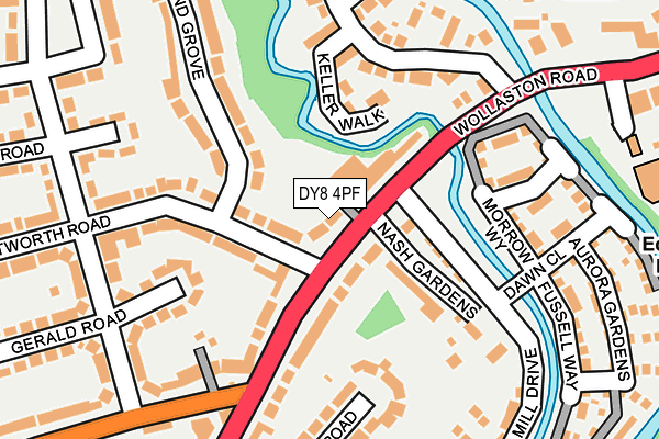
DY8 4PF lies on High Street in Wollaston, Stourbridge. DY8 4PF is located in the Wollaston and Stourbridge Town electoral ward, within the metropolitan district of Dudley and the English Parliamentary constituency of Stourbridge. The Sub Integrated Care Board (ICB) Location is NHS Black Country ICB - D2P2L and the police force is West Midlands. This postcode has been in use since January 1980.


GetTheData
Source: OS OpenMap – Local (Ordnance Survey)
Source: OS VectorMap District (Ordnance Survey)
Licence: Open Government Licence (requires attribution)
| Easting | 389388 |
| Northing | 285369 |
| Latitude | 52.466170 |
| Longitude | -2.157625 |
GetTheData
Source: Open Postcode Geo
Licence: Open Government Licence
| Street | High Street |
| Locality | Wollaston |
| Town/City | Stourbridge |
| Country | England |
| Postcode District | DY8 |
➜ See where DY8 is on a map ➜ Where is Stourbridge? | |
GetTheData
Source: Land Registry Price Paid Data
Licence: Open Government Licence
Elevation or altitude of DY8 4PF as distance above sea level:
| Metres | Feet | |
|---|---|---|
| Elevation | 70m | 230ft |
Elevation is measured from the approximate centre of the postcode, to the nearest point on an OS contour line from OS Terrain 50, which has contour spacing of ten vertical metres.
➜ How high above sea level am I? Find the elevation of your current position using your device's GPS.
GetTheData
Source: Open Postcode Elevation
Licence: Open Government Licence
| Ward | Wollaston And Stourbridge Town |
| Constituency | Stourbridge |
GetTheData
Source: ONS Postcode Database
Licence: Open Government Licence
| High St (Vicarage Rd) | Wollaston | 227m |
| Apley Road (High St) | Wollaston | 248m |
| Wentworth Rd (Gerald Rd) | Wollaston Farm | 252m |
| Wentworth Rd (Gerald Rd) | Wollaston Farm | 258m |
| Apley Road (High St) | Wollaston | 283m |
| Stourbridge Town Station | 1.6km |
| Stourbridge Junction Station | 2.6km |
| Lye (West Midlands) Station | 2.9km |
GetTheData
Source: NaPTAN
Licence: Open Government Licence
| Percentage of properties with Next Generation Access | 100.0% |
| Percentage of properties with Superfast Broadband | 100.0% |
| Percentage of properties with Ultrafast Broadband | 66.7% |
| Percentage of properties with Full Fibre Broadband | 0.0% |
Superfast Broadband is between 30Mbps and 300Mbps
Ultrafast Broadband is > 300Mbps
| Median download speed | 78.1Mbps |
| Average download speed | 60.5Mbps |
| Maximum download speed | 100.00Mbps |
| Median upload speed | 19.5Mbps |
| Average upload speed | 13.1Mbps |
| Maximum upload speed | 20.00Mbps |
| Percentage of properties unable to receive 2Mbps | 0.0% |
| Percentage of properties unable to receive 5Mbps | 0.0% |
| Percentage of properties unable to receive 10Mbps | 0.0% |
| Percentage of properties unable to receive 30Mbps | 0.0% |
GetTheData
Source: Ofcom
Licence: Ofcom Terms of Use (requires attribution)
Estimated total energy consumption in DY8 4PF by fuel type, 2015.
| Consumption (kWh) | 111,906 |
|---|---|
| Meter count | 7 |
| Mean (kWh/meter) | 15,987 |
| Median (kWh/meter) | 14,648 |
| Consumption (kWh) | 18,851 |
|---|---|
| Meter count | 6 |
| Mean (kWh/meter) | 3,142 |
| Median (kWh/meter) | 3,647 |
GetTheData
Source: Postcode level gas estimates: 2015 (experimental)
Source: Postcode level electricity estimates: 2015 (experimental)
Licence: Open Government Licence
GetTheData
Source: ONS Postcode Database
Licence: Open Government Licence


➜ Get more ratings from the Food Standards Agency
GetTheData
Source: Food Standards Agency
Licence: FSA terms & conditions
| Last Collection | |||
|---|---|---|---|
| Location | Mon-Fri | Sat | Distance |
| Apley Road | 18:45 | 10:30 | 202m |
| Amblecote Post Office | 18:30 | 11:15 | 590m |
| Caslon Crescent | 17:15 | 11:00 | 742m |
GetTheData
Source: Dracos
Licence: Creative Commons Attribution-ShareAlike
The below table lists the International Territorial Level (ITL) codes (formerly Nomenclature of Territorial Units for Statistics (NUTS) codes) and Local Administrative Units (LAU) codes for DY8 4PF:
| ITL 1 Code | Name |
|---|---|
| TLG | West Midlands (England) |
| ITL 2 Code | Name |
| TLG3 | West Midlands |
| ITL 3 Code | Name |
| TLG36 | Dudley |
| LAU 1 Code | Name |
| E08000027 | Dudley |
GetTheData
Source: ONS Postcode Directory
Licence: Open Government Licence
The below table lists the Census Output Area (OA), Lower Layer Super Output Area (LSOA), and Middle Layer Super Output Area (MSOA) for DY8 4PF:
| Code | Name | |
|---|---|---|
| OA | E00050120 | |
| LSOA | E01009909 | Dudley 029C |
| MSOA | E02002028 | Dudley 029 |
GetTheData
Source: ONS Postcode Directory
Licence: Open Government Licence
| DY8 4GB | Hyde Mill Drive | 61m |
| DY8 4GA | Nash Gardens | 82m |
| DY8 4SD | Wentworth Road | 109m |
| DY8 4PE | High Street | 109m |
| DY8 4GE | Morrow Way | 156m |
| DY8 4BF | Keller Walk | 159m |
| DY8 4PA | Apley Road | 166m |
| DY8 4NZ | High Street | 182m |
| DY8 4SB | Wentworth Road | 190m |
| DY8 4GD | Hyde Mill Drive | 190m |
GetTheData
Source: Open Postcode Geo; Land Registry Price Paid Data
Licence: Open Government Licence