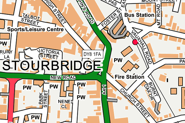
DY8 1FA is located in the Wollaston and Stourbridge Town electoral ward, within the metropolitan district of Dudley and the English Parliamentary constituency of Stourbridge. The Sub Integrated Care Board (ICB) Location is NHS Black Country ICB - D2P2L and the police force is West Midlands. This postcode has been in use since December 2001.


GetTheData
Source: OS OpenMap – Local (Ordnance Survey)
Source: OS VectorMap District (Ordnance Survey)
Licence: Open Government Licence (requires attribution)
| Easting | 390316 |
| Northing | 284126 |
| Latitude | 52.455013 |
| Longitude | -2.143929 |
GetTheData
Source: Open Postcode Geo
Licence: Open Government Licence
| Country | England |
| Postcode District | DY8 |
➜ See where DY8 is on a map ➜ Where is Stourbridge? | |
GetTheData
Source: Land Registry Price Paid Data
Licence: Open Government Licence
Elevation or altitude of DY8 1FA as distance above sea level:
| Metres | Feet | |
|---|---|---|
| Elevation | 90m | 295ft |
Elevation is measured from the approximate centre of the postcode, to the nearest point on an OS contour line from OS Terrain 50, which has contour spacing of ten vertical metres.
➜ How high above sea level am I? Find the elevation of your current position using your device's GPS.
GetTheData
Source: Open Postcode Elevation
Licence: Open Government Licence
| Ward | Wollaston And Stourbridge Town |
| Constituency | Stourbridge |
GetTheData
Source: ONS Postcode Database
Licence: Open Government Licence
| Town Centre (High St) | Stourbridge | 83m |
| Stourbridge Fire Station (Church St) | Stourbridge | 91m |
| Union St (Hagley Rd) | Stourbridge | 131m |
| Vauxhall Rd (Parkfield Rd) | Stourbridge | 180m |
| Union St (Hagley Rd) | Stourbridge | 204m |
| Stourbridge Town Station | 0.2km |
| Stourbridge Junction Station | 1.1km |
| Lye (West Midlands) Station | 2km |
GetTheData
Source: NaPTAN
Licence: Open Government Licence
GetTheData
Source: ONS Postcode Database
Licence: Open Government Licence


➜ Get more ratings from the Food Standards Agency
GetTheData
Source: Food Standards Agency
Licence: FSA terms & conditions
| Last Collection | |||
|---|---|---|---|
| Location | Mon-Fri | Sat | Distance |
| Stourbridge Post Office | 19:00 | 11:45 | 199m |
| Worcester Street | 18:30 | 10:30 | 268m |
| Upper High Street | 18:45 | 11:45 | 268m |
GetTheData
Source: Dracos
Licence: Creative Commons Attribution-ShareAlike
The below table lists the International Territorial Level (ITL) codes (formerly Nomenclature of Territorial Units for Statistics (NUTS) codes) and Local Administrative Units (LAU) codes for DY8 1FA:
| ITL 1 Code | Name |
|---|---|
| TLG | West Midlands (England) |
| ITL 2 Code | Name |
| TLG3 | West Midlands |
| ITL 3 Code | Name |
| TLG36 | Dudley |
| LAU 1 Code | Name |
| E08000027 | Dudley |
GetTheData
Source: ONS Postcode Directory
Licence: Open Government Licence
The below table lists the Census Output Area (OA), Lower Layer Super Output Area (LSOA), and Middle Layer Super Output Area (MSOA) for DY8 1FA:
| Code | Name | |
|---|---|---|
| OA | E00049846 | |
| LSOA | E01009856 | Dudley 035A |
| MSOA | E02002034 | Dudley 035 |
GetTheData
Source: ONS Postcode Directory
Licence: Open Government Licence
| DY8 1EQ | High Street | 5m |
| DY8 1ED | High Street | 33m |
| DY8 1EJ | St Johns Road | 51m |
| DY8 1PH | New Road | 68m |
| DY8 1EL | Foster Street | 85m |
| DY8 1SS | Bath Road | 86m |
| DY8 1QH | Hagley Road | 97m |
| DY8 1PS | Hagley Road | 99m |
| DY8 1LT | Church Street | 103m |
| DY8 1DX | High Street | 125m |
GetTheData
Source: Open Postcode Geo; Land Registry Price Paid Data
Licence: Open Government Licence