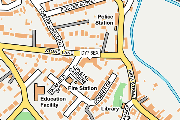
DY7 6EX lies on Stone Lane in Kinver, Stourbridge. DY7 6EX is located in the Kinver & Enville electoral ward, within the local authority district of South Staffordshire and the English Parliamentary constituency of South Staffordshire. The Sub Integrated Care Board (ICB) Location is NHS Staffordshire and Stoke-on-Trent ICB - 05Q and the police force is Staffordshire. This postcode has been in use since January 2016.


GetTheData
Source: OS OpenMap – Local (Ordnance Survey)
Source: OS VectorMap District (Ordnance Survey)
Licence: Open Government Licence (requires attribution)
| Easting | 384374 |
| Northing | 283535 |
| Latitude | 52.449547 |
| Longitude | -2.231348 |
GetTheData
Source: Open Postcode Geo
Licence: Open Government Licence
| Street | Stone Lane |
| Locality | Kinver |
| Town/City | Stourbridge |
| Country | England |
| Postcode District | DY7 |
➜ See where DY7 is on a map ➜ Where is Kinver? | |
GetTheData
Source: Land Registry Price Paid Data
Licence: Open Government Licence
Elevation or altitude of DY7 6EX as distance above sea level:
| Metres | Feet | |
|---|---|---|
| Elevation | 50m | 164ft |
Elevation is measured from the approximate centre of the postcode, to the nearest point on an OS contour line from OS Terrain 50, which has contour spacing of ten vertical metres.
➜ How high above sea level am I? Find the elevation of your current position using your device's GPS.
GetTheData
Source: Open Postcode Elevation
Licence: Open Government Licence
| Ward | Kinver & Enville |
| Constituency | South Staffordshire |
GetTheData
Source: ONS Postcode Database
Licence: Open Government Licence
| Plough And Harrow Ph (High Street) | Kinver | 124m |
| Police Station (High Street) | Kinver | 145m |
| Police Station (High Street) | Kinver | 148m |
| Health Centre (High Street) | Kinver | 211m |
| Post Office (High Street) | Kinver | 246m |
| Blakedown Station | 6.1km |
GetTheData
Source: NaPTAN
Licence: Open Government Licence
| Percentage of properties with Next Generation Access | 100.0% |
| Percentage of properties with Superfast Broadband | 100.0% |
| Percentage of properties with Ultrafast Broadband | 0.0% |
| Percentage of properties with Full Fibre Broadband | 0.0% |
Superfast Broadband is between 30Mbps and 300Mbps
Ultrafast Broadband is > 300Mbps
| Median download speed | 40.0Mbps |
| Average download speed | 47.0Mbps |
| Maximum download speed | 80.00Mbps |
| Median upload speed | 10.0Mbps |
| Average upload speed | 10.0Mbps |
| Maximum upload speed | 20.00Mbps |
| Percentage of properties unable to receive 2Mbps | 0.0% |
| Percentage of properties unable to receive 5Mbps | 0.0% |
| Percentage of properties unable to receive 10Mbps | 0.0% |
| Percentage of properties unable to receive 30Mbps | 0.0% |
GetTheData
Source: Ofcom
Licence: Ofcom Terms of Use (requires attribution)
GetTheData
Source: ONS Postcode Database
Licence: Open Government Licence


➜ Get more ratings from the Food Standards Agency
GetTheData
Source: Food Standards Agency
Licence: FSA terms & conditions
| Last Collection | |||
|---|---|---|---|
| Location | Mon-Fri | Sat | Distance |
| Meddins Lane | 17:00 | 10:45 | 1,470m |
| Enville Road | 18:30 | 10:45 | 1,997m |
| Cookley Post Office | 17:00 | 10:00 | 3,203m |
GetTheData
Source: Dracos
Licence: Creative Commons Attribution-ShareAlike
The below table lists the International Territorial Level (ITL) codes (formerly Nomenclature of Territorial Units for Statistics (NUTS) codes) and Local Administrative Units (LAU) codes for DY7 6EX:
| ITL 1 Code | Name |
|---|---|
| TLG | West Midlands (England) |
| ITL 2 Code | Name |
| TLG2 | Shropshire and Staffordshire |
| ITL 3 Code | Name |
| TLG24 | Staffordshire CC |
| LAU 1 Code | Name |
| E07000196 | South Staffordshire |
GetTheData
Source: ONS Postcode Directory
Licence: Open Government Licence
The below table lists the Census Output Area (OA), Lower Layer Super Output Area (LSOA), and Middle Layer Super Output Area (MSOA) for DY7 6EX:
| Code | Name | |
|---|---|---|
| OA | E00151084 | |
| LSOA | E01029649 | South Staffordshire 014A |
| MSOA | E02006187 | South Staffordshire 014 |
GetTheData
Source: ONS Postcode Directory
Licence: Open Government Licence
| DY7 6EQ | Stone Lane | 44m |
| DY7 6DG | Crystal Gardens | 56m |
| DY7 6EG | Stone Lane | 78m |
| DY7 6EN | Comber Grove | 112m |
| DY7 6EW | Fairfield Drive | 120m |
| DY7 6ES | High Street | 120m |
| DY7 6ER | High Street | 140m |
| DY7 6HD | High Street | 146m |
| DY7 6DZ | Stone Lane | 155m |
| DY7 6HE | High Street | 167m |
GetTheData
Source: Open Postcode Geo; Land Registry Price Paid Data
Licence: Open Government Licence