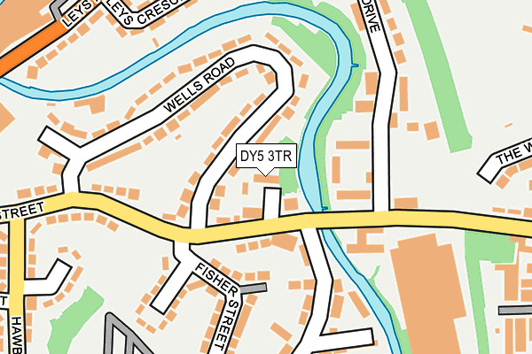
DY5 3TR is located in the Brierley Hill electoral ward, within the metropolitan district of Dudley and the English Parliamentary constituency of Dudley South. The Sub Integrated Care Board (ICB) Location is NHS Black Country ICB - D2P2L and the police force is West Midlands. This postcode has been in use since November 2014.


GetTheData
Source: OS OpenMap – Local (Ordnance Survey)
Source: OS VectorMap District (Ordnance Survey)
Licence: Open Government Licence (requires attribution)
| Easting | 390830 |
| Northing | 287156 |
| Latitude | 52.482262 |
| Longitude | -2.136449 |
GetTheData
Source: Open Postcode Geo
Licence: Open Government Licence
| Country | England |
| Postcode District | DY5 |
➜ See where DY5 is on a map ➜ Where is Brierley Hill? | |
GetTheData
Source: Land Registry Price Paid Data
Licence: Open Government Licence
Elevation or altitude of DY5 3TR as distance above sea level:
| Metres | Feet | |
|---|---|---|
| Elevation | 110m | 361ft |
Elevation is measured from the approximate centre of the postcode, to the nearest point on an OS contour line from OS Terrain 50, which has contour spacing of ten vertical metres.
➜ How high above sea level am I? Find the elevation of your current position using your device's GPS.
GetTheData
Source: Open Postcode Elevation
Licence: Open Government Licence
| Ward | Brierley Hill |
| Constituency | Dudley South |
GetTheData
Source: ONS Postcode Database
Licence: Open Government Licence
| Addison Rd (Moor St) | Brockmoor | 66m |
| Addison Rd (Moor St) | Brockmoor | 107m |
| Wells Rd (Moor St) | Buckpool | 247m |
| Charlton St (Hawbush Rd) | Buckpool | 277m |
| Canal Bridge (Leys Rd) | Buckpool | 305m |
| Lye (West Midlands) Station | 2.8km |
| Stourbridge Town Station | 3km |
| Cradley Heath Station | 3.4km |
GetTheData
Source: NaPTAN
Licence: Open Government Licence
| Percentage of properties with Next Generation Access | 100.0% |
| Percentage of properties with Superfast Broadband | 100.0% |
| Percentage of properties with Ultrafast Broadband | 100.0% |
| Percentage of properties with Full Fibre Broadband | 0.0% |
Superfast Broadband is between 30Mbps and 300Mbps
Ultrafast Broadband is > 300Mbps
| Median download speed | 15.1Mbps |
| Average download speed | 51.3Mbps |
| Maximum download speed | 159.88Mbps |
| Median upload speed | 1.2Mbps |
| Average upload speed | 9.6Mbps |
| Maximum upload speed | 30.01Mbps |
| Percentage of properties unable to receive 2Mbps | 0.0% |
| Percentage of properties unable to receive 5Mbps | 0.0% |
| Percentage of properties unable to receive 10Mbps | 0.0% |
| Percentage of properties unable to receive 30Mbps | 0.0% |
GetTheData
Source: Ofcom
Licence: Ofcom Terms of Use (requires attribution)
GetTheData
Source: ONS Postcode Database
Licence: Open Government Licence


➜ Get more ratings from the Food Standards Agency
GetTheData
Source: Food Standards Agency
Licence: FSA terms & conditions
| Last Collection | |||
|---|---|---|---|
| Location | Mon-Fri | Sat | Distance |
| Fenton Street | 17:30 | 11:30 | 675m |
| Silver End Post Office | 17:30 | 12:00 | 766m |
| Church Street | 17:30 | 12:00 | 788m |
GetTheData
Source: Dracos
Licence: Creative Commons Attribution-ShareAlike
The below table lists the International Territorial Level (ITL) codes (formerly Nomenclature of Territorial Units for Statistics (NUTS) codes) and Local Administrative Units (LAU) codes for DY5 3TR:
| ITL 1 Code | Name |
|---|---|
| TLG | West Midlands (England) |
| ITL 2 Code | Name |
| TLG3 | West Midlands |
| ITL 3 Code | Name |
| TLG36 | Dudley |
| LAU 1 Code | Name |
| E08000027 | Dudley |
GetTheData
Source: ONS Postcode Directory
Licence: Open Government Licence
The below table lists the Census Output Area (OA), Lower Layer Super Output Area (LSOA), and Middle Layer Super Output Area (MSOA) for DY5 3TR:
| Code | Name | |
|---|---|---|
| OA | E00049317 | |
| LSOA | E01009743 | Dudley 023D |
| MSOA | E02002022 | Dudley 023 |
GetTheData
Source: ONS Postcode Directory
Licence: Open Government Licence
| DY5 3TA | Moor Street | 40m |
| DY5 3TB | Wells Road | 111m |
| DY5 3SW | Moor Street | 120m |
| DY5 3TD | Wells Road | 153m |
| DY5 3RY | Addison Road | 169m |
| DY5 3SA | Fisher Street | 170m |
| DY5 3GZ | Foxdale Drive | 172m |
| DY5 3SB | Fisher Street | 175m |
| DY5 3GY | Foxdale Drive | 223m |
| DY5 3UN | Leys Crescent | 236m |
GetTheData
Source: Open Postcode Geo; Land Registry Price Paid Data
Licence: Open Government Licence