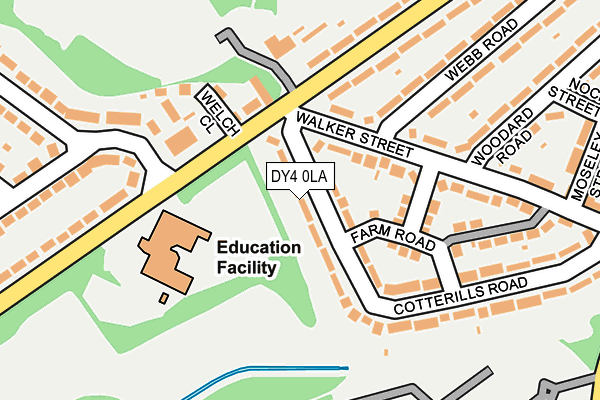
DY4 0LA lies on Cotterills Road in Tipton. DY4 0LA is located in the Great Bridge electoral ward, within the metropolitan district of Sandwell and the English Parliamentary constituency of West Bromwich West. The Sub Integrated Care Board (ICB) Location is NHS Black Country ICB - D2P2L and the police force is West Midlands. This postcode has been in use since January 1980.


GetTheData
Source: OS OpenMap – Local (Ordnance Survey)
Source: OS VectorMap District (Ordnance Survey)
Licence: Open Government Licence (requires attribution)
| Easting | 396889 |
| Northing | 293163 |
| Latitude | 52.536319 |
| Longitude | -2.047296 |
GetTheData
Source: Open Postcode Geo
Licence: Open Government Licence
| Street | Cotterills Road |
| Town/City | Tipton |
| Country | England |
| Postcode District | DY4 |
➜ See where DY4 is on a map ➜ Where is Tipton? | |
GetTheData
Source: Land Registry Price Paid Data
Licence: Open Government Licence
Elevation or altitude of DY4 0LA as distance above sea level:
| Metres | Feet | |
|---|---|---|
| Elevation | 130m | 427ft |
Elevation is measured from the approximate centre of the postcode, to the nearest point on an OS contour line from OS Terrain 50, which has contour spacing of ten vertical metres.
➜ How high above sea level am I? Find the elevation of your current position using your device's GPS.
GetTheData
Source: Open Postcode Elevation
Licence: Open Government Licence
| Ward | Great Bridge |
| Constituency | West Bromwich West |
GetTheData
Source: ONS Postcode Database
Licence: Open Government Licence
| Cotterills Lane (Powis Ave) | Summer Hill | 80m |
| Cotterills Lane (Powis Ave) | Summer Hill | 121m |
| Bourne Avenue (Powis Ave) | Ocker Hill | 339m |
| Joseph Turner School (Powis Ave) | Summer Hill | 357m |
| Powis Avenue (Bourne Ave) | Dudley Port | 366m |
| Wednesbury Parkway (Midland Metro Stop) (Leabrook Rd) | Wednesbury | 1,851m |
| Dudley Port Station | 1.3km |
| Tipton Station | 1.4km |
| Coseley Station | 2.8km |
GetTheData
Source: NaPTAN
Licence: Open Government Licence
| Percentage of properties with Next Generation Access | 100.0% |
| Percentage of properties with Superfast Broadband | 100.0% |
| Percentage of properties with Ultrafast Broadband | 100.0% |
| Percentage of properties with Full Fibre Broadband | 0.0% |
Superfast Broadband is between 30Mbps and 300Mbps
Ultrafast Broadband is > 300Mbps
| Median download speed | 68.2Mbps |
| Average download speed | 69.6Mbps |
| Maximum download speed | 200.00Mbps |
| Median upload speed | 9.8Mbps |
| Average upload speed | 8.3Mbps |
| Maximum upload speed | 19.53Mbps |
| Percentage of properties unable to receive 2Mbps | 0.0% |
| Percentage of properties unable to receive 5Mbps | 0.0% |
| Percentage of properties unable to receive 10Mbps | 0.0% |
| Percentage of properties unable to receive 30Mbps | 0.0% |
GetTheData
Source: Ofcom
Licence: Ofcom Terms of Use (requires attribution)
Estimated total energy consumption in DY4 0LA by fuel type, 2015.
| Consumption (kWh) | 306,957 |
|---|---|
| Meter count | 28 |
| Mean (kWh/meter) | 10,963 |
| Median (kWh/meter) | 9,974 |
| Consumption (kWh) | 81,700 |
|---|---|
| Meter count | 27 |
| Mean (kWh/meter) | 3,026 |
| Median (kWh/meter) | 2,586 |
GetTheData
Source: Postcode level gas estimates: 2015 (experimental)
Source: Postcode level electricity estimates: 2015 (experimental)
Licence: Open Government Licence
GetTheData
Source: ONS Postcode Database
Licence: Open Government Licence


➜ Get more ratings from the Food Standards Agency
GetTheData
Source: Food Standards Agency
Licence: FSA terms & conditions
| Last Collection | |||
|---|---|---|---|
| Location | Mon-Fri | Sat | Distance |
| Templeway | 17:15 | 12:00 | 603m |
| Foxyards | 17:30 | 11:00 | 627m |
| Highfield Road | 17:30 | 11:00 | 635m |
GetTheData
Source: Dracos
Licence: Creative Commons Attribution-ShareAlike
The below table lists the International Territorial Level (ITL) codes (formerly Nomenclature of Territorial Units for Statistics (NUTS) codes) and Local Administrative Units (LAU) codes for DY4 0LA:
| ITL 1 Code | Name |
|---|---|
| TLG | West Midlands (England) |
| ITL 2 Code | Name |
| TLG3 | West Midlands |
| ITL 3 Code | Name |
| TLG37 | Sandwell |
| LAU 1 Code | Name |
| E08000028 | Sandwell |
GetTheData
Source: ONS Postcode Directory
Licence: Open Government Licence
The below table lists the Census Output Area (OA), Lower Layer Super Output Area (LSOA), and Middle Layer Super Output Area (MSOA) for DY4 0LA:
| Code | Name | |
|---|---|---|
| OA | E00050488 | |
| LSOA | E01009983 | Sandwell 009B |
| MSOA | E02002051 | Sandwell 009 |
GetTheData
Source: ONS Postcode Directory
Licence: Open Government Licence
| DY4 0LB | Walker Street | 62m |
| DY4 0RL | Powis Avenue | 108m |
| DY4 0JZ | Cotterills Road | 123m |
| DY4 0JX | Farm Road | 127m |
| DY4 0LH | Walker Street | 129m |
| DY4 0NA | Welch Close | 161m |
| DY4 0LG | Webb Road | 177m |
| DY4 0NG | Glebefields Road | 179m |
| DY4 0JU | Walker Street | 209m |
| DY4 0RJ | Powis Avenue | 215m |
GetTheData
Source: Open Postcode Geo; Land Registry Price Paid Data
Licence: Open Government Licence