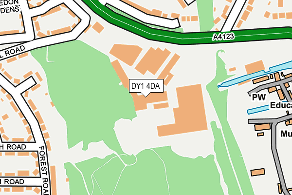
DY1 4DA is located in the Castle and Priory electoral ward, within the metropolitan district of Dudley and the English Parliamentary constituency of Dudley North. The Sub Integrated Care Board (ICB) Location is NHS Black Country ICB - D2P2L and the police force is West Midlands. This postcode has been in use since January 2004.


GetTheData
Source: OS OpenMap – Local (Ordnance Survey)
Source: OS VectorMap District (Ordnance Survey)
Licence: Open Government Licence (requires attribution)
| Easting | 394617 |
| Northing | 291666 |
| Latitude | 52.522859 |
| Longitude | -2.080761 |
GetTheData
Source: Open Postcode Geo
Licence: Open Government Licence
| Country | England |
| Postcode District | DY1 |
➜ See where DY1 is on a map ➜ Where is Dudley? | |
GetTheData
Source: Land Registry Price Paid Data
Licence: Open Government Licence
Elevation or altitude of DY1 4DA as distance above sea level:
| Metres | Feet | |
|---|---|---|
| Elevation | 160m | 525ft |
Elevation is measured from the approximate centre of the postcode, to the nearest point on an OS contour line from OS Terrain 50, which has contour spacing of ten vertical metres.
➜ How high above sea level am I? Find the elevation of your current position using your device's GPS.
GetTheData
Source: Open Postcode Elevation
Licence: Open Government Licence
| Ward | Castle And Priory |
| Constituency | Dudley North |
GetTheData
Source: ONS Postcode Database
Licence: Open Government Licence
| Castle Mill Works (Birmingham New Rd) | Priory Estate | 127m |
| Castle Mill Works (Birmingham New Rd) | Priory Estate | 151m |
| Beech Road (Forest Rd) | Priory Estate | 261m |
| Beech Road (Forest Rd) | Priory Estate | 268m |
| Castle Mill Road (Forest Rd) | Priory Estate | 338m |
| Tipton Station | 1.3km |
| Dudley Port Station | 2.1km |
| Coseley Station | 2.5km |
GetTheData
Source: NaPTAN
Licence: Open Government Licence
| Median download speed | 39.7Mbps |
| Average download speed | 38.9Mbps |
| Maximum download speed | 79.58Mbps |
| Median upload speed | 8.8Mbps |
| Average upload speed | 9.0Mbps |
| Maximum upload speed | 19.12Mbps |
GetTheData
Source: Ofcom
Licence: Ofcom Terms of Use (requires attribution)
GetTheData
Source: ONS Postcode Database
Licence: Open Government Licence


➜ Get more ratings from the Food Standards Agency
GetTheData
Source: Food Standards Agency
Licence: FSA terms & conditions
| Last Collection | |||
|---|---|---|---|
| Location | Mon-Fri | Sat | Distance |
| The Priory Post Office Box | 17:30 | 11:00 | 446m |
| Tipton Arms | 17:30 | 11:00 | 584m |
| Park Lane | 17:30 | 11:00 | 1,027m |
GetTheData
Source: Dracos
Licence: Creative Commons Attribution-ShareAlike
The below table lists the International Territorial Level (ITL) codes (formerly Nomenclature of Territorial Units for Statistics (NUTS) codes) and Local Administrative Units (LAU) codes for DY1 4DA:
| ITL 1 Code | Name |
|---|---|
| TLG | West Midlands (England) |
| ITL 2 Code | Name |
| TLG3 | West Midlands |
| ITL 3 Code | Name |
| TLG36 | Dudley |
| LAU 1 Code | Name |
| E08000027 | Dudley |
GetTheData
Source: ONS Postcode Directory
Licence: Open Government Licence
The below table lists the Census Output Area (OA), Lower Layer Super Output Area (LSOA), and Middle Layer Super Output Area (MSOA) for DY1 4DA:
| Code | Name | |
|---|---|---|
| OA | E00049371 | |
| LSOA | E01009757 | Dudley 006C |
| MSOA | E02002005 | Dudley 006 |
GetTheData
Source: ONS Postcode Directory
Licence: Open Government Licence
| DY1 4BZ | Castle Mill Road | 257m |
| DY4 8AQ | Silverthorne Avenue | 262m |
| DY1 4BX | Forest Road | 269m |
| DY4 8DZ | Castle Road | 290m |
| DY1 4FG | Shrewsbury Place | 300m |
| DY1 4BU | Forest Road | 307m |
| DY1 4BS | Beech Road | 309m |
| DY1 4BA | Forest Road | 326m |
| DY4 8AN | Helford Close | 340m |
| DY1 4BY | Castle Mill Road | 341m |
GetTheData
Source: Open Postcode Geo; Land Registry Price Paid Data
Licence: Open Government Licence