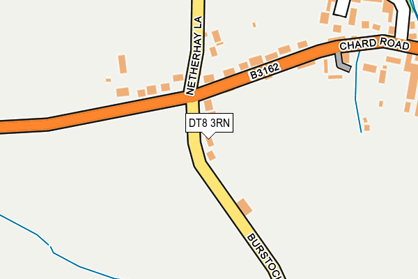
DT8 3RN lies on Burstock Lane in Drimpton, Beaminster. DT8 3RN is located in the Marshwood Vale electoral ward, within the unitary authority of Dorset and the English Parliamentary constituency of West Dorset. The Sub Integrated Care Board (ICB) Location is NHS Dorset ICB - 11J and the police force is Dorset. This postcode has been in use since January 1980.


GetTheData
Source: OS OpenMap – Local (Ordnance Survey)
Source: OS VectorMap District (Ordnance Survey)
Licence: Open Government Licence (requires attribution)
| Easting | 341448 |
| Northing | 104822 |
| Latitude | 50.839940 |
| Longitude | -2.832930 |
GetTheData
Source: Open Postcode Geo
Licence: Open Government Licence
| Street | Burstock Lane |
| Locality | Drimpton |
| Town/City | Beaminster |
| Country | England |
| Postcode District | DT8 |
➜ See where DT8 is on a map ➜ Where is Drimpton? | |
GetTheData
Source: Land Registry Price Paid Data
Licence: Open Government Licence
Elevation or altitude of DT8 3RN as distance above sea level:
| Metres | Feet | |
|---|---|---|
| Elevation | 110m | 361ft |
Elevation is measured from the approximate centre of the postcode, to the nearest point on an OS contour line from OS Terrain 50, which has contour spacing of ten vertical metres.
➜ How high above sea level am I? Find the elevation of your current position using your device's GPS.
GetTheData
Source: Open Postcode Elevation
Licence: Open Government Licence
| Ward | Marshwood Vale |
| Constituency | West Dorset |
GetTheData
Source: ONS Postcode Database
Licence: Open Government Licence
5, BURSTOCK LANE, DRIMPTON, BEAMINSTER, DT8 3RN 2019 4 OCT £325,000 |
SPEKES, 3, BURSTOCK LANE, DRIMPTON, BEAMINSTER, DT8 3RN 2013 31 OCT £250,000 |
OAKLEAF COTTAGE, BURSTOCK LANE, DRIMPTON, BEAMINSTER, DT8 3RN 2006 16 JUN £345,000 |
2004 31 AUG £300,000 |
SPEKES, 3, BURSTOCK LANE, DRIMPTON, BEAMINSTER, DT8 3RN 2004 27 JUL £232,000 |
1996 8 NOV £96,500 |
GetTheData
Source: HM Land Registry Price Paid Data
Licence: Contains HM Land Registry data © Crown copyright and database right 2025. This data is licensed under the Open Government Licence v3.0.
| Royal Oak (Chard Lane) | Drimpton | 484m |
| Royal Oak (Chard Lane) | Drimpton | 497m |
| Royal Oak (Bridport Road) | Drimpton | 509m |
| Royal Oak | Drimpton | 514m |
| Netherhay Lane | Drimpton | 538m |
| Crewkerne Station | 5.4km |
GetTheData
Source: NaPTAN
Licence: Open Government Licence
| Percentage of properties with Next Generation Access | 100.0% |
| Percentage of properties with Superfast Broadband | 100.0% |
| Percentage of properties with Ultrafast Broadband | 0.0% |
| Percentage of properties with Full Fibre Broadband | 0.0% |
Superfast Broadband is between 30Mbps and 300Mbps
Ultrafast Broadband is > 300Mbps
| Percentage of properties unable to receive 2Mbps | 0.0% |
| Percentage of properties unable to receive 5Mbps | 0.0% |
| Percentage of properties unable to receive 10Mbps | 0.0% |
| Percentage of properties unable to receive 30Mbps | 0.0% |
GetTheData
Source: Ofcom
Licence: Ofcom Terms of Use (requires attribution)
GetTheData
Source: ONS Postcode Database
Licence: Open Government Licence

➜ Get more ratings from the Food Standards Agency
GetTheData
Source: Food Standards Agency
Licence: FSA terms & conditions
| Last Collection | |||
|---|---|---|---|
| Location | Mon-Fri | Sat | Distance |
| Drimpton P.o. | 15:45 | 09:00 | 292m |
| Netherhay | 15:30 | 09:00 | 548m |
| Laymore | 10:00 | 08:30 | 2,634m |
GetTheData
Source: Dracos
Licence: Creative Commons Attribution-ShareAlike
The below table lists the International Territorial Level (ITL) codes (formerly Nomenclature of Territorial Units for Statistics (NUTS) codes) and Local Administrative Units (LAU) codes for DT8 3RN:
| ITL 1 Code | Name |
|---|---|
| TLK | South West (England) |
| ITL 2 Code | Name |
| TLK2 | Dorset and Somerset |
| ITL 3 Code | Name |
| TLK25 | Dorset |
| LAU 1 Code | Name |
| E06000059 | Dorset |
GetTheData
Source: ONS Postcode Directory
Licence: Open Government Licence
The below table lists the Census Output Area (OA), Lower Layer Super Output Area (LSOA), and Middle Layer Super Output Area (MSOA) for DT8 3RN:
| Code | Name | |
|---|---|---|
| OA | E00103966 | |
| LSOA | E01020506 | West Dorset 003D |
| MSOA | E02004271 | West Dorset 003 |
GetTheData
Source: ONS Postcode Directory
Licence: Open Government Licence
| DT8 3RL | Netherhay Lane | 128m |
| DT8 3RW | Spearmead | 228m |
| DT8 3RP | Oxhayes | 275m |
| DT8 3RF | Chard Road | 278m |
| DT8 3RR | Post Office Yard | 310m |
| DT8 3RZ | Marksmead | 384m |
| DT8 3RX | Chard Road | 411m |
| DT8 3RY | Applefield Road | 419m |
| DT8 3RQ | Orchard Close | 452m |
| DT8 3RG | Crewkerne Road | 482m |
GetTheData
Source: Open Postcode Geo; Land Registry Price Paid Data
Licence: Open Government Licence