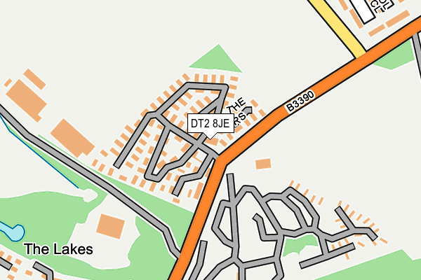
DT2 8JE is located in the Crossways electoral ward, within the unitary authority of Dorset and the English Parliamentary constituency of South Dorset. The Sub Integrated Care Board (ICB) Location is NHS Dorset ICB - 11J and the police force is Dorset. This postcode has been in use since January 1980.


GetTheData
Source: OS OpenMap – Local (Ordnance Survey)
Source: OS VectorMap District (Ordnance Survey)
Licence: Open Government Licence (requires attribution)
| Easting | 376234 |
| Northing | 87714 |
| Latitude | 50.688577 |
| Longitude | -2.337797 |
GetTheData
Source: Open Postcode Geo
Licence: Open Government Licence
| Country | England |
| Postcode District | DT2 |
➜ See where DT2 is on a map ➜ Where is Crossways? | |
GetTheData
Source: Land Registry Price Paid Data
Licence: Open Government Licence
Elevation or altitude of DT2 8JE as distance above sea level:
| Metres | Feet | |
|---|---|---|
| Elevation | 50m | 164ft |
Elevation is measured from the approximate centre of the postcode, to the nearest point on an OS contour line from OS Terrain 50, which has contour spacing of ten vertical metres.
➜ How high above sea level am I? Find the elevation of your current position using your device's GPS.
GetTheData
Source: Open Postcode Elevation
Licence: Open Government Licence
| Ward | Crossways |
| Constituency | South Dorset |
GetTheData
Source: ONS Postcode Database
Licence: Open Government Licence
| Warmwell Leisure Resort | Crossways | 87m |
| Warmwell Leisure Resort (Warmwell Road) | Crossways | 103m |
| Empool Close (Mount Skippet Way) | Crossways | 683m |
| Empool Close (Mount Skippet Way) | Crossways | 690m |
| Post Office (Mount Skippet Way) | Crossways | 865m |
| Moreton (Dorset) Station | 2.2km |
GetTheData
Source: NaPTAN
Licence: Open Government Licence
GetTheData
Source: ONS Postcode Database
Licence: Open Government Licence


➜ Get more ratings from the Food Standards Agency
GetTheData
Source: Food Standards Agency
Licence: FSA terms & conditions
| Last Collection | |||
|---|---|---|---|
| Location | Mon-Fri | Sat | Distance |
| Norht East Caravan Park | 12:45 | 10:30 | 350m |
| Paul Ways Crossways | 12:30 | 11:00 | 1,055m |
| Dick O The Banks | 12:30 | 11:00 | 1,203m |
GetTheData
Source: Dracos
Licence: Creative Commons Attribution-ShareAlike
The below table lists the International Territorial Level (ITL) codes (formerly Nomenclature of Territorial Units for Statistics (NUTS) codes) and Local Administrative Units (LAU) codes for DT2 8JE:
| ITL 1 Code | Name |
|---|---|
| TLK | South West (England) |
| ITL 2 Code | Name |
| TLK2 | Dorset and Somerset |
| ITL 3 Code | Name |
| TLK25 | Dorset |
| LAU 1 Code | Name |
| E06000059 | Dorset |
GetTheData
Source: ONS Postcode Directory
Licence: Open Government Licence
The below table lists the Census Output Area (OA), Lower Layer Super Output Area (LSOA), and Middle Layer Super Output Area (MSOA) for DT2 8JE:
| Code | Name | |
|---|---|---|
| OA | E00104157 | |
| LSOA | E01020537 | West Dorset 011B |
| MSOA | E02004279 | West Dorset 011 |
GetTheData
Source: ONS Postcode Directory
Licence: Open Government Licence
| DT2 8JQ | Oaklands Park | 342m |
| DT2 8BX | Empool Close | 657m |
| DT2 8BU | Mount Skippet Way | 703m |
| DT2 8TN | Airfield Close | 712m |
| DT2 8BN | Combe Way | 781m |
| DT2 8BF | Hybris Business Park | 807m |
| DT2 8TT | Hope Close | 811m |
| DT2 8TZ | Spitfire Close | 817m |
| DT2 8TY | Hurricane Close | 826m |
| DT2 8TP | Mount Skippet Way | 840m |
GetTheData
Source: Open Postcode Geo; Land Registry Price Paid Data
Licence: Open Government Licence