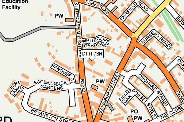
DT11 7BH is located in the Blandford electoral ward, within the unitary authority of Dorset and the English Parliamentary constituency of North Dorset. The Sub Integrated Care Board (ICB) Location is NHS Dorset ICB - 11J and the police force is Dorset. This postcode has been in use since January 1980.


GetTheData
Source: OS OpenMap – Local (Ordnance Survey)
Source: OS VectorMap District (Ordnance Survey)
Licence: Open Government Licence (requires attribution)
| Easting | 388467 |
| Northing | 106620 |
| Latitude | 50.858974 |
| Longitude | -2.165227 |
GetTheData
Source: Open Postcode Geo
Licence: Open Government Licence
| Country | England |
| Postcode District | DT11 |
➜ See where DT11 is on a map ➜ Where is Blandford Forum? | |
GetTheData
Source: Land Registry Price Paid Data
Licence: Open Government Licence
Elevation or altitude of DT11 7BH as distance above sea level:
| Metres | Feet | |
|---|---|---|
| Elevation | 50m | 164ft |
Elevation is measured from the approximate centre of the postcode, to the nearest point on an OS contour line from OS Terrain 50, which has contour spacing of ten vertical metres.
➜ How high above sea level am I? Find the elevation of your current position using your device's GPS.
GetTheData
Source: Open Postcode Elevation
Licence: Open Government Licence
| Ward | Blandford |
| Constituency | North Dorset |
GetTheData
Source: ONS Postcode Database
Licence: Open Government Licence
| The Half Moon (Mill Street) | Blandford Forum | 143m |
| Fairfield Road (Salisbury Road) | Blandford Forum | 249m |
| Fairfield Road (Salisbury Road) | Blandford Forum | 257m |
| Market Place | Blandford Forum | 351m |
| Blandford Hospital (Milldown Road) | Blandford Forum | 351m |
GetTheData
Source: NaPTAN
Licence: Open Government Licence
GetTheData
Source: ONS Postcode Database
Licence: Open Government Licence


➜ Get more ratings from the Food Standards Agency
GetTheData
Source: Food Standards Agency
Licence: FSA terms & conditions
| Last Collection | |||
|---|---|---|---|
| Location | Mon-Fri | Sat | Distance |
| Badger | 16:00 | 11:30 | 161m |
| Milldown Road | 16:00 | 11:00 | 339m |
| Queens Road | 16:00 | 11:30 | 592m |
GetTheData
Source: Dracos
Licence: Creative Commons Attribution-ShareAlike
The below table lists the International Territorial Level (ITL) codes (formerly Nomenclature of Territorial Units for Statistics (NUTS) codes) and Local Administrative Units (LAU) codes for DT11 7BH:
| ITL 1 Code | Name |
|---|---|
| TLK | South West (England) |
| ITL 2 Code | Name |
| TLK2 | Dorset and Somerset |
| ITL 3 Code | Name |
| TLK25 | Dorset |
| LAU 1 Code | Name |
| E06000059 | Dorset |
GetTheData
Source: ONS Postcode Directory
Licence: Open Government Licence
The below table lists the Census Output Area (OA), Lower Layer Super Output Area (LSOA), and Middle Layer Super Output Area (MSOA) for DT11 7BH:
| Code | Name | |
|---|---|---|
| OA | E00103573 | |
| LSOA | E01020438 | North Dorset 007D |
| MSOA | E02004261 | North Dorset 007 |
GetTheData
Source: ONS Postcode Directory
Licence: Open Government Licence
| DT11 7BQ | Whitecliff Mill Street | 36m |
| DT11 7BU | White Cliff Gardens | 56m |
| DT11 7PY | Salisbury Street | 84m |
| DT11 7PS | Salisbury Street | 103m |
| DT11 7QE | Salisbury Street | 109m |
| DT11 7BX | Park Road | 131m |
| DT11 7RE | North Place | 134m |
| DT11 7PW | North Place | 136m |
| DT11 7BN | Whitecliff Mill Street | 143m |
| DT11 7BE | Whitecliff Mill Street | 144m |
GetTheData
Source: Open Postcode Geo; Land Registry Price Paid Data
Licence: Open Government Licence