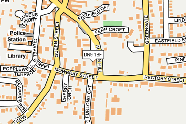
DN9 1BF lies on Albion Hill in Epworth, Doncaster. DN9 1BF is located in the Axholme Central electoral ward, within the unitary authority of North Lincolnshire and the English Parliamentary constituency of Brigg and Goole. The Sub Integrated Care Board (ICB) Location is NHS Humber and North Yorkshire ICB - 03K and the police force is Humberside. This postcode has been in use since March 2011.


GetTheData
Source: OS OpenMap – Local (Ordnance Survey)
Source: OS VectorMap District (Ordnance Survey)
Licence: Open Government Licence (requires attribution)
| Easting | 478425 |
| Northing | 403614 |
| Latitude | 53.523351 |
| Longitude | -0.818529 |
GetTheData
Source: Open Postcode Geo
Licence: Open Government Licence
| Street | Albion Hill |
| Locality | Epworth |
| Town/City | Doncaster |
| Country | England |
| Postcode District | DN9 |
➜ See where DN9 is on a map ➜ Where is Epworth? | |
GetTheData
Source: Land Registry Price Paid Data
Licence: Open Government Licence
Elevation or altitude of DN9 1BF as distance above sea level:
| Metres | Feet | |
|---|---|---|
| Elevation | 20m | 66ft |
Elevation is measured from the approximate centre of the postcode, to the nearest point on an OS contour line from OS Terrain 50, which has contour spacing of ten vertical metres.
➜ How high above sea level am I? Find the elevation of your current position using your device's GPS.
GetTheData
Source: Open Postcode Elevation
Licence: Open Government Licence
| Ward | Axholme Central |
| Constituency | Brigg And Goole |
GetTheData
Source: ONS Postcode Database
Licence: Open Government Licence
| Albion Hill | Epworth | 105m |
| The Old Rectory (Rectory Street) | Epworth | 196m |
| Market Place | Epworth | 198m |
| The Old Rectory (Rectory Street) | Epworth | 218m |
| Woodland Way (Rectory Street) | Epworth | 368m |
GetTheData
Source: NaPTAN
Licence: Open Government Licence
| Percentage of properties with Next Generation Access | 100.0% |
| Percentage of properties with Superfast Broadband | 100.0% |
| Percentage of properties with Ultrafast Broadband | 0.0% |
| Percentage of properties with Full Fibre Broadband | 0.0% |
Superfast Broadband is between 30Mbps and 300Mbps
Ultrafast Broadband is > 300Mbps
| Percentage of properties unable to receive 2Mbps | 0.0% |
| Percentage of properties unable to receive 5Mbps | 0.0% |
| Percentage of properties unable to receive 10Mbps | 0.0% |
| Percentage of properties unable to receive 30Mbps | 0.0% |
GetTheData
Source: Ofcom
Licence: Ofcom Terms of Use (requires attribution)
GetTheData
Source: ONS Postcode Database
Licence: Open Government Licence


➜ Get more ratings from the Food Standards Agency
GetTheData
Source: Food Standards Agency
Licence: FSA terms & conditions
| Last Collection | |||
|---|---|---|---|
| Location | Mon-Fri | Sat | Distance |
| Rectory Street | 17:00 | 11:30 | 122m |
| Blow Road | 17:00 | 12:00 | 379m |
| Epworth Post Office | 16:45 | 11:30 | 386m |
GetTheData
Source: Dracos
Licence: Creative Commons Attribution-ShareAlike
The below table lists the International Territorial Level (ITL) codes (formerly Nomenclature of Territorial Units for Statistics (NUTS) codes) and Local Administrative Units (LAU) codes for DN9 1BF:
| ITL 1 Code | Name |
|---|---|
| TLE | Yorkshire and The Humber |
| ITL 2 Code | Name |
| TLE1 | East Yorkshire and Northern Lincolnshire |
| ITL 3 Code | Name |
| TLE13 | North and North East Lincolnshire |
| LAU 1 Code | Name |
| E06000013 | North Lincolnshire |
GetTheData
Source: ONS Postcode Directory
Licence: Open Government Licence
The below table lists the Census Output Area (OA), Lower Layer Super Output Area (LSOA), and Middle Layer Super Output Area (MSOA) for DN9 1BF:
| Code | Name | |
|---|---|---|
| OA | E00066822 | |
| LSOA | E01013241 | North Lincolnshire 020A |
| MSOA | E02002768 | North Lincolnshire 020 |
GetTheData
Source: ONS Postcode Directory
Licence: Open Government Licence
| DN9 1HR | Mowbray Street | 71m |
| DN9 1GE | Fern Croft | 115m |
| DN9 1HD | Albion Hill | 124m |
| DN9 1SJ | Rookery Croft | 141m |
| DN9 1HG | Queen Street | 149m |
| DN9 1GB | South Furlong Croft | 155m |
| DN9 1SS | Fairfield Croft | 168m |
| DN9 1TR | Cherry Orchard | 171m |
| DN9 1HB | Rectory Street | 184m |
| DN9 1HJ | Chapel Street | 190m |
GetTheData
Source: Open Postcode Geo; Land Registry Price Paid Data
Licence: Open Government Licence