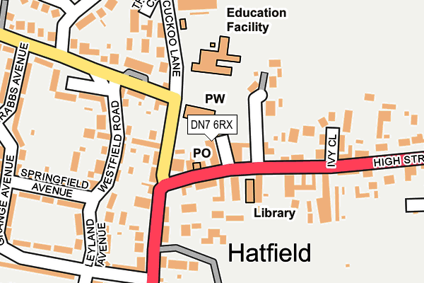
DN7 6RX is located in the Hatfield electoral ward, within the metropolitan district of Doncaster and the English Parliamentary constituency of Don Valley. The Sub Integrated Care Board (ICB) Location is NHS South Yorkshire ICB - 02X and the police force is South Yorkshire. This postcode has been in use since January 1980.


GetTheData
Source: OS OpenMap – Local (Ordnance Survey)
Source: OS VectorMap District (Ordnance Survey)
Licence: Open Government Licence (requires attribution)
| Easting | 466332 |
| Northing | 409535 |
| Latitude | 53.578246 |
| Longitude | -0.999654 |
GetTheData
Source: Open Postcode Geo
Licence: Open Government Licence
| Country | England |
| Postcode District | DN7 |
➜ See where DN7 is on a map ➜ Where is Hatfield? | |
GetTheData
Source: Land Registry Price Paid Data
Licence: Open Government Licence
Elevation or altitude of DN7 6RX as distance above sea level:
| Metres | Feet | |
|---|---|---|
| Elevation | 10m | 33ft |
Elevation is measured from the approximate centre of the postcode, to the nearest point on an OS contour line from OS Terrain 50, which has contour spacing of ten vertical metres.
➜ How high above sea level am I? Find the elevation of your current position using your device's GPS.
GetTheData
Source: Open Postcode Elevation
Licence: Open Government Licence
| Ward | Hatfield |
| Constituency | Don Valley |
GetTheData
Source: ONS Postcode Database
Licence: Open Government Licence
1A, CHURCH WALK, HATFIELD, DONCASTER, DN7 6RX 2019 1 NOV £187,500 |
GetTheData
Source: HM Land Registry Price Paid Data
Licence: Contains HM Land Registry data © Crown copyright and database right 2025. This data is licensed under the Open Government Licence v3.0.
| The Bay Horse (High Street) | Hatfield | 45m |
| Hatfield Library (High Street) | Hatfield | 61m |
| Cuckoo Lane | Hatfield | 175m |
| Westfield Green (Westfield Road) | Hatfield | 205m |
| Grange Avenue (Manor Road) | Hatfield | 239m |
| Hatfield & Stainforth Station | 2km |
| Thorne South Station | 4.1km |
| Thorne North Station | 4.6km |
GetTheData
Source: NaPTAN
Licence: Open Government Licence
| Percentage of properties with Next Generation Access | 100.0% |
| Percentage of properties with Superfast Broadband | 100.0% |
| Percentage of properties with Ultrafast Broadband | 0.0% |
| Percentage of properties with Full Fibre Broadband | 0.0% |
Superfast Broadband is between 30Mbps and 300Mbps
Ultrafast Broadband is > 300Mbps
| Percentage of properties unable to receive 2Mbps | 0.0% |
| Percentage of properties unable to receive 5Mbps | 0.0% |
| Percentage of properties unable to receive 10Mbps | 0.0% |
| Percentage of properties unable to receive 30Mbps | 0.0% |
GetTheData
Source: Ofcom
Licence: Ofcom Terms of Use (requires attribution)
GetTheData
Source: ONS Postcode Database
Licence: Open Government Licence


➜ Get more ratings from the Food Standards Agency
GetTheData
Source: Food Standards Agency
Licence: FSA terms & conditions
| Last Collection | |||
|---|---|---|---|
| Location | Mon-Fri | Sat | Distance |
| Hatfield Post Office | 16:30 | 11:15 | 38m |
| South End | 16:00 | 09:00 | 643m |
| Crooksbroomlane | 16:30 | 09:00 | 892m |
GetTheData
Source: Dracos
Licence: Creative Commons Attribution-ShareAlike
The below table lists the International Territorial Level (ITL) codes (formerly Nomenclature of Territorial Units for Statistics (NUTS) codes) and Local Administrative Units (LAU) codes for DN7 6RX:
| ITL 1 Code | Name |
|---|---|
| TLE | Yorkshire and The Humber |
| ITL 2 Code | Name |
| TLE3 | South Yorkshire |
| ITL 3 Code | Name |
| TLE31 | Barnsley, Doncaster and Rotherham |
| LAU 1 Code | Name |
| E08000017 | Doncaster |
GetTheData
Source: ONS Postcode Directory
Licence: Open Government Licence
The below table lists the Census Output Area (OA), Lower Layer Super Output Area (LSOA), and Middle Layer Super Output Area (MSOA) for DN7 6RX:
| Code | Name | |
|---|---|---|
| OA | E00038289 | |
| LSOA | E01007553 | Doncaster 008A |
| MSOA | E02001546 | Doncaster 008 |
GetTheData
Source: ONS Postcode Directory
Licence: Open Government Licence
| DN7 6HN | Vicarage Close | 92m |
| DN7 6PY | Station Road | 98m |
| DN7 6RT | Maltby Villas | 130m |
| DN7 6RU | Ivy Close | 147m |
| DN7 6RY | High Street | 159m |
| DN7 6SB | Manor Road | 165m |
| DN7 6PZ | Westfield Road | 166m |
| DN7 6ST | Manor Gardens | 170m |
| DN7 6RS | High Street | 184m |
| DN7 6RQ | Leyland Avenue | 198m |
GetTheData
Source: Open Postcode Geo; Land Registry Price Paid Data
Licence: Open Government Licence