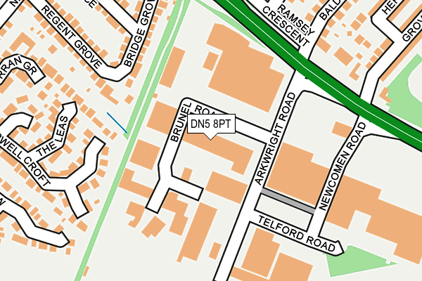
DN5 8PT is located in the Bentley electoral ward, within the metropolitan district of Doncaster and the English Parliamentary constituency of Doncaster North. The Sub Integrated Care Board (ICB) Location is NHS South Yorkshire ICB - 02X and the police force is South Yorkshire. This postcode has been in use since September 2005.


GetTheData
Source: OS OpenMap – Local (Ordnance Survey)
Source: OS VectorMap District (Ordnance Survey)
Licence: Open Government Licence (requires attribution)
| Easting | 455889 |
| Northing | 404286 |
| Latitude | 53.532285 |
| Longitude | -1.158290 |
GetTheData
Source: Open Postcode Geo
Licence: Open Government Licence
| Country | England |
| Postcode District | DN5 |
➜ See where DN5 is on a map ➜ Where is Bentley? | |
GetTheData
Source: Land Registry Price Paid Data
Licence: Open Government Licence
Elevation or altitude of DN5 8PT as distance above sea level:
| Metres | Feet | |
|---|---|---|
| Elevation | 10m | 33ft |
Elevation is measured from the approximate centre of the postcode, to the nearest point on an OS contour line from OS Terrain 50, which has contour spacing of ten vertical metres.
➜ How high above sea level am I? Find the elevation of your current position using your device's GPS.
GetTheData
Source: Open Postcode Elevation
Licence: Open Government Licence
| Ward | Bentley |
| Constituency | Doncaster North |
GetTheData
Source: ONS Postcode Database
Licence: Open Government Licence
| Baldwin Avenue (York Road) | York Road | 192m |
| Newcomen Road (York Road) | York Road | 198m |
| Ivanhoe Close (Anchorage Lane) | Sprotbrough | 298m |
| Regent Grove (Newlands Drive) | Cusworth | 308m |
| Newbold Terrace (Newlands Drive) | Cusworth | 324m |
| Bentley (S Yorks) Station | 1.4km |
| Doncaster Station | 1.7km |
| Adwick Station | 4.7km |
GetTheData
Source: NaPTAN
Licence: Open Government Licence
GetTheData
Source: ONS Postcode Database
Licence: Open Government Licence


➜ Get more ratings from the Food Standards Agency
GetTheData
Source: Food Standards Agency
Licence: FSA terms & conditions
| Last Collection | |||
|---|---|---|---|
| Location | Mon-Fri | Sat | Distance |
| Baldwin Avenue | 17:30 | 12:15 | 233m |
| Newlands Drive | 17:30 | 11:45 | 350m |
| Watch House Lane | 17:15 | 11:15 | 528m |
GetTheData
Source: Dracos
Licence: Creative Commons Attribution-ShareAlike
The below table lists the International Territorial Level (ITL) codes (formerly Nomenclature of Territorial Units for Statistics (NUTS) codes) and Local Administrative Units (LAU) codes for DN5 8PT:
| ITL 1 Code | Name |
|---|---|
| TLE | Yorkshire and The Humber |
| ITL 2 Code | Name |
| TLE3 | South Yorkshire |
| ITL 3 Code | Name |
| TLE31 | Barnsley, Doncaster and Rotherham |
| LAU 1 Code | Name |
| E08000017 | Doncaster |
GetTheData
Source: ONS Postcode Directory
Licence: Open Government Licence
The below table lists the Census Output Area (OA), Lower Layer Super Output Area (LSOA), and Middle Layer Super Output Area (MSOA) for DN5 8PT:
| Code | Name | |
|---|---|---|
| OA | E00038449 | |
| LSOA | E01007581 | Doncaster 016A |
| MSOA | E02001554 | Doncaster 016 |
GetTheData
Source: ONS Postcode Directory
Licence: Open Government Licence
| DN5 8HP | Bridge Grove | 147m |
| DN5 8UW | The Leas | 168m |
| DN5 8HS | Regent Grove | 202m |
| DN5 8UT | Charnock Drive | 205m |
| DN5 9BJ | Ramsey Crescent | 219m |
| DN5 8HR | Newbold Terrace | 233m |
| DN5 8UN | Rothesay Close | 236m |
| DN5 8UL | Clearwell Croft | 237m |
| DN5 8UJ | Perran Grove | 244m |
| DN5 8HW | Williams Road | 258m |
GetTheData
Source: Open Postcode Geo; Land Registry Price Paid Data
Licence: Open Government Licence