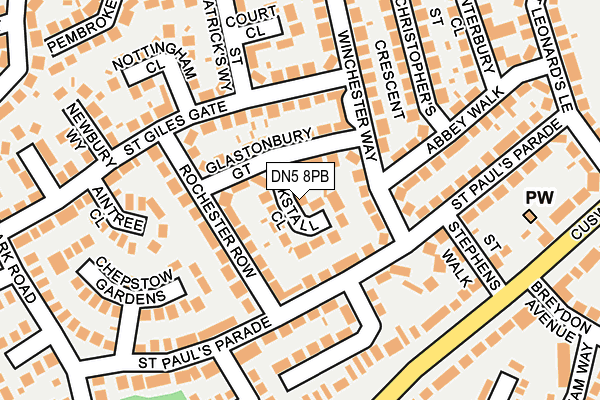
DN5 8PB lies on Kirkstall Close in Doncaster. DN5 8PB is located in the Roman Ridge electoral ward, within the metropolitan district of Doncaster and the English Parliamentary constituency of Doncaster North. The Sub Integrated Care Board (ICB) Location is NHS South Yorkshire ICB - 02X and the police force is South Yorkshire. This postcode has been in use since January 1980.


GetTheData
Source: OS OpenMap – Local (Ordnance Survey)
Source: OS VectorMap District (Ordnance Survey)
Licence: Open Government Licence (requires attribution)
| Easting | 454982 |
| Northing | 404441 |
| Latitude | 53.533754 |
| Longitude | -1.171943 |
GetTheData
Source: Open Postcode Geo
Licence: Open Government Licence
| Street | Kirkstall Close |
| Town/City | Doncaster |
| Country | England |
| Postcode District | DN5 |
➜ See where DN5 is on a map ➜ Where is Scawsby? | |
GetTheData
Source: Land Registry Price Paid Data
Licence: Open Government Licence
Elevation or altitude of DN5 8PB as distance above sea level:
| Metres | Feet | |
|---|---|---|
| Elevation | 30m | 98ft |
Elevation is measured from the approximate centre of the postcode, to the nearest point on an OS contour line from OS Terrain 50, which has contour spacing of ten vertical metres.
➜ How high above sea level am I? Find the elevation of your current position using your device's GPS.
GetTheData
Source: Open Postcode Elevation
Licence: Open Government Licence
| Ward | Roman Ridge |
| Constituency | Doncaster North |
GetTheData
Source: ONS Postcode Database
Licence: Open Government Licence
| St Stephens Walk (Cusworth Lane) | Cusworth | 204m |
| Filby Road (Cusworth Lane) | Cusworth | 213m |
| Pembroke Rise (St Davids Drive) | Scawsby | 254m |
| Breydon Avenue (Cusworth Lane) | Cusworth | 255m |
| St Clements Close (St Davids Drive) | Scawsby | 263m |
| Bentley (S Yorks) Station | 1.8km |
| Doncaster Station | 2.5km |
| Adwick Station | 4.3km |
GetTheData
Source: NaPTAN
Licence: Open Government Licence
| Percentage of properties with Next Generation Access | 100.0% |
| Percentage of properties with Superfast Broadband | 100.0% |
| Percentage of properties with Ultrafast Broadband | 100.0% |
| Percentage of properties with Full Fibre Broadband | 0.0% |
Superfast Broadband is between 30Mbps and 300Mbps
Ultrafast Broadband is > 300Mbps
| Median download speed | 34.7Mbps |
| Average download speed | 69.8Mbps |
| Maximum download speed | 200.00Mbps |
| Median upload speed | 1.0Mbps |
| Average upload speed | 1.2Mbps |
| Maximum upload speed | 2.49Mbps |
| Percentage of properties unable to receive 2Mbps | 0.0% |
| Percentage of properties unable to receive 5Mbps | 0.0% |
| Percentage of properties unable to receive 10Mbps | 0.0% |
| Percentage of properties unable to receive 30Mbps | 0.0% |
GetTheData
Source: Ofcom
Licence: Ofcom Terms of Use (requires attribution)
Estimated total energy consumption in DN5 8PB by fuel type, 2015.
| Consumption (kWh) | 325,739 |
|---|---|
| Meter count | 25 |
| Mean (kWh/meter) | 13,030 |
| Median (kWh/meter) | 12,816 |
| Consumption (kWh) | 68,002 |
|---|---|
| Meter count | 22 |
| Mean (kWh/meter) | 3,091 |
| Median (kWh/meter) | 2,850 |
GetTheData
Source: Postcode level gas estimates: 2015 (experimental)
Source: Postcode level electricity estimates: 2015 (experimental)
Licence: Open Government Licence
GetTheData
Source: ONS Postcode Database
Licence: Open Government Licence


➜ Get more ratings from the Food Standards Agency
GetTheData
Source: Food Standards Agency
Licence: FSA terms & conditions
| Last Collection | |||
|---|---|---|---|
| Location | Mon-Fri | Sat | Distance |
| Breydon Avenue | 17:00 | 11:45 | 250m |
| St Davids Drive | 17:00 | 11:45 | 301m |
| Kempton Park Road | 17:30 | 11:15 | 324m |
GetTheData
Source: Dracos
Licence: Creative Commons Attribution-ShareAlike
The below table lists the International Territorial Level (ITL) codes (formerly Nomenclature of Territorial Units for Statistics (NUTS) codes) and Local Administrative Units (LAU) codes for DN5 8PB:
| ITL 1 Code | Name |
|---|---|
| TLE | Yorkshire and The Humber |
| ITL 2 Code | Name |
| TLE3 | South Yorkshire |
| ITL 3 Code | Name |
| TLE31 | Barnsley, Doncaster and Rotherham |
| LAU 1 Code | Name |
| E08000017 | Doncaster |
GetTheData
Source: ONS Postcode Directory
Licence: Open Government Licence
The below table lists the Census Output Area (OA), Lower Layer Super Output Area (LSOA), and Middle Layer Super Output Area (MSOA) for DN5 8PB:
| Code | Name | |
|---|---|---|
| OA | E00038448 | |
| LSOA | E01007589 | Doncaster 016D |
| MSOA | E02001554 | Doncaster 016 |
GetTheData
Source: ONS Postcode Directory
Licence: Open Government Licence
| DN5 8PA | Glastonbury Gate | 33m |
| DN5 8LL | Winchester Way | 66m |
| DN5 8PD | Glastonbury Gate | 67m |
| DN5 8PE | Rochester Row | 99m |
| DN5 8PG | St Giles Gate | 107m |
| DN5 8PF | Rochester Row | 116m |
| DN5 8LJ | St Pauls Parade | 122m |
| DN5 8PJ | St Giles Gate | 130m |
| DN5 8LE | St Pauls Parade | 132m |
| DN5 8LH | Roehampton Rise | 140m |
GetTheData
Source: Open Postcode Geo; Land Registry Price Paid Data
Licence: Open Government Licence