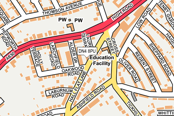
DN4 8PU is located in the Balby South electoral ward, within the metropolitan district of Doncaster and the English Parliamentary constituency of Doncaster Central. The Sub Integrated Care Board (ICB) Location is NHS South Yorkshire ICB - 02X and the police force is South Yorkshire. This postcode has been in use since January 1980.


GetTheData
Source: OS OpenMap – Local (Ordnance Survey)
Source: OS VectorMap District (Ordnance Survey)
Licence: Open Government Licence (requires attribution)
| Easting | 456063 |
| Northing | 401126 |
| Latitude | 53.503867 |
| Longitude | -1.156230 |
GetTheData
Source: Open Postcode Geo
Licence: Open Government Licence
| Country | England |
| Postcode District | DN4 |
➜ See where DN4 is on a map ➜ Where is Doncaster? | |
GetTheData
Source: Land Registry Price Paid Data
Licence: Open Government Licence
Elevation or altitude of DN4 8PU as distance above sea level:
| Metres | Feet | |
|---|---|---|
| Elevation | 20m | 66ft |
Elevation is measured from the approximate centre of the postcode, to the nearest point on an OS contour line from OS Terrain 50, which has contour spacing of ten vertical metres.
➜ How high above sea level am I? Find the elevation of your current position using your device's GPS.
GetTheData
Source: Open Postcode Elevation
Licence: Open Government Licence
| Ward | Balby South |
| Constituency | Doncaster Central |
GetTheData
Source: ONS Postcode Database
Licence: Open Government Licence
| Hall Flat Lane (Warmsworth Road) | Balby | 94m |
| Oswin Avenue (Warmsworth Road) | Balby | 96m |
| Oswin Avenue (Thomson Avenue) | Balby | 184m |
| Cedar Road (Springwell Lane) | Balby | 227m |
| Dixon Crescent (Thomson Avenue) | Balby | 266m |
| Doncaster Station | 2.3km |
| Bentley (S Yorks) Station | 4.5km |
GetTheData
Source: NaPTAN
Licence: Open Government Licence
GetTheData
Source: ONS Postcode Database
Licence: Open Government Licence


➜ Get more ratings from the Food Standards Agency
GetTheData
Source: Food Standards Agency
Licence: FSA terms & conditions
| Last Collection | |||
|---|---|---|---|
| Location | Mon-Fri | Sat | Distance |
| Cross Street | 17:30 | 11:15 | 104m |
| Warmsworth Road Post Office | 18:30 | 11:45 | 347m |
| Sandford Road P.o. | 17:00 | 11:30 | 536m |
GetTheData
Source: Dracos
Licence: Creative Commons Attribution-ShareAlike
The below table lists the International Territorial Level (ITL) codes (formerly Nomenclature of Territorial Units for Statistics (NUTS) codes) and Local Administrative Units (LAU) codes for DN4 8PU:
| ITL 1 Code | Name |
|---|---|
| TLE | Yorkshire and The Humber |
| ITL 2 Code | Name |
| TLE3 | South Yorkshire |
| ITL 3 Code | Name |
| TLE31 | Barnsley, Doncaster and Rotherham |
| LAU 1 Code | Name |
| E08000017 | Doncaster |
GetTheData
Source: ONS Postcode Directory
Licence: Open Government Licence
The below table lists the Census Output Area (OA), Lower Layer Super Output Area (LSOA), and Middle Layer Super Output Area (MSOA) for DN4 8PU:
| Code | Name | |
|---|---|---|
| OA | E00038019 | |
| LSOA | E01007495 | Doncaster 028A |
| MSOA | E02001566 | Doncaster 028 |
GetTheData
Source: ONS Postcode Directory
Licence: Open Government Licence
| DN4 8RH | Laurel Terrace | 28m |
| DN4 8RF | Alder Grove | 29m |
| DN4 8PT | Hall Flat Lane | 37m |
| DN4 8PS | Cross Street | 79m |
| DN4 8RG | Larchfield Road | 92m |
| DN4 8QB | Ashfield Road | 92m |
| DN4 8PR | Cross Street | 106m |
| DN4 0NN | High Road | 110m |
| DN4 8RQ | Oakwood Road | 115m |
| DN4 8PP | Low Road | 134m |
GetTheData
Source: Open Postcode Geo; Land Registry Price Paid Data
Licence: Open Government Licence